Weather
Cold front approaching with possible snow showers for Memorial Day Weekend
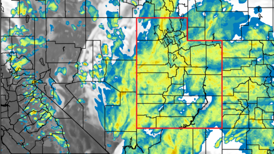
A storm system will cross Utah Saturday morning, bringing a cold front and precipitation. Photo: TownLift.
PARK CITY, Utah. — A cold front is expected to settle in this weekend and into early next week, dropping the temperature by roughly 26 degrees in Park City from Friday to Sunday with chances of precipitation and even snow, according to the National Weather Service (NWS) in Salt Lake City.
NWS said that conditions will become increasingly cool over the Holiday weekend and into next week as a Pacific Northwest storm system moves through Utah.
Trying to plan your Memorial Day Weekend? Here is the current breakdown of probability of precipitation for our list of cities in Utah and SW WY. Check back for forecast updates! #utwx #wywx pic.twitter.com/aDbnCfQsOm
— NWS Salt Lake City (@NWSSaltLakeCity) May 27, 2022
Park City Forecast:
Friday
Mostly sunny, with a high near 76. Southeast wind 8 to 14 mph becoming southwest in the afternoon.
Friday night
A slight chance of showers and thunderstorms before 9 p.m., then a slight chance of showers between 9 p.m. and midnight. Mostly cloudy, with a low around 48. Southwest wind 6 to 14 mph becoming west northwest in the evening. Chance of precipitation is 20%.
Saturday
Showers likely, then showers and possibly a thunderstorm after noon. High near 61. West wind 8 to 13 mph. Chance of precipitation is 80%.
Saturday night
A chance of showers and thunderstorms, then showers and possibly a thunderstorm after midnight. Low around 40. West wind 7 to 13 mph becoming south southeast after midnight. Chance of precipitation is 80%.
Sunday
Showers and possibly a thunderstorm. High near 50. South southwest wind 10 to 13 mph becoming west northwest in the afternoon. Chance of precipitation is 90%.
Sunday night
Rain and snow showers likely, becoming all snow after 3am. Some thunder is also possible. Mostly cloudy, with a low around 33. Chance of precipitation is 60%. New snow accumulation of less than a half inch possible.
Monday
Snow showers before noon, then rain and snow showers. Some thunder is also possible. High near 49. Chance of precipitation is 80%. New snow accumulation of less than a half inch possible.
Monday night
A chance of rain and snow showers. Mostly cloudy, with a low around 32.
Tuesday
A chance of snow showers before 9am, then a chance of rain and snow showers between 9am and noon, then a chance of rain showers after noon. Partly sunny, with a high near 55.
Tuesday night
A slight chance of showers before midnight. Partly cloudy, with a low around 34.
Wednesday
Sunny, with a high near 64.
Wednesday night
Mostly clear, with a low around 41.
Thursday
Sunny, with a high near 74.
By: TownLift

1511 S Valley View Circle
Springville, UT 84663
2075 E Munsey Drive
Moab, UT 84532
371 N Pinion Hills Drive
Dammeron Valley, UT 84783
8905 Parleys Lane
Park City, UT 84098Talk of the Town


Park City Jobs
Property Inspector, Park City Rental Properties
1 day ago Full time $23.00 hourly

Junction Commons Retail Openings, Junction Commons
1 day ago Part time $16.00 - $22.00 hourly

Accounting & Office Administrator, Canyons Village Management Association
5 days ago Full time $65,000 - $70,000 yearly

Operations Houskeeping Manager - Year Round, Casago
5 days ago Full time $19.00 - $23.00 hourly

Property Manager, Mountain Estates Property Management
7 days ago Full time