Weather
Winter returns this week with a foot of snow to kick off April
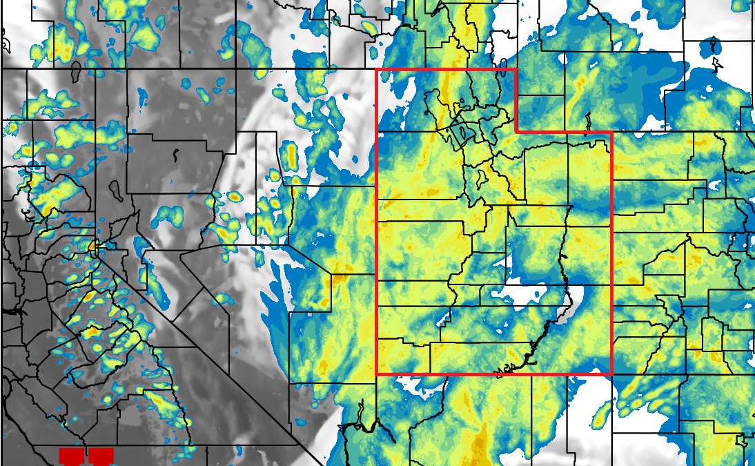
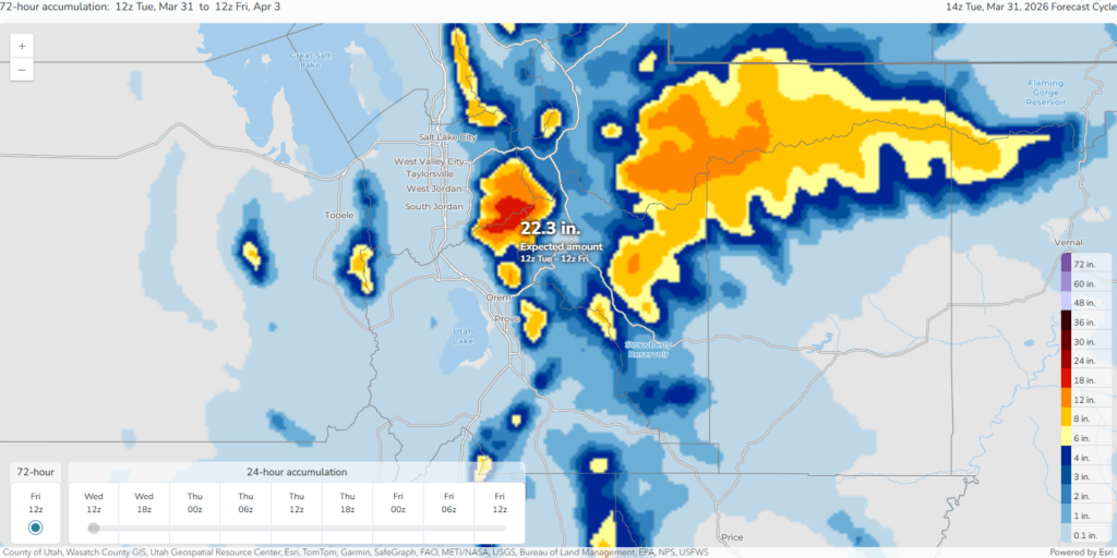
Photo: The HRRR weather model shows precipitation covering most of the state overnight as the first cold front moves through Utah // UofU Dept. of Atmospheric Sciences
1 to 2 feet of snow expected for the Wasatch Mountains overnight tonight through Friday
PARK CITY, Utah – After one of the worst winters on record and an historic heat wave to start off the spring season, winter finally returns to Utah late Tuesday night as a series of winter storms is on track to move through the region.
Moisture is already streaming into Utah Tuesday with scattered high-based showers throughout the day with mild temperatures and gusty winds. The first cold front is expected to cross through the area overnight into Wednesday morning, bringing a burst of heavy snowfall in the higher elevation mountains with some thunder possible.
Snow levels will start out near 9,000 feet and drop closer to 7,000 feet by Wednesday morning.
This first storm should drop about 6-14” of dense snow throughout the Wasatch Range, with a chance for some flurries in town by the morning commute as colder air aligns with early hours.
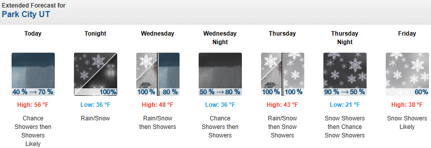
Forecast Snow Totals through Friday
- Cottonwood Canyons: 14 – 28″
- Deer Valley/PCMR: 7 – 13″
- N. Wasatch (Powder/Snowbasin): 12 – 22”
- PC Base/Town: 1 – 3″ (Thurs/Fri)
Second Colder Storm Thursday
After a brief lull Wednesday evening, the next storm system is already approaching from the northwest, which will bring much colder air with it. This second cold front is forecast to arrive around midday Thursday, likely dropping snow levels to the Salt Lake Valley by Friday morning with a dusting possible.
This second storm has less moisture but much colder air, which means the snow will be more of the classic, lower density Utah powder than the first storm. Expect an additional 6-14″ of snow out of this second storm, with most snow showers looking to taper off by Friday morning as the system begins to exit the region.
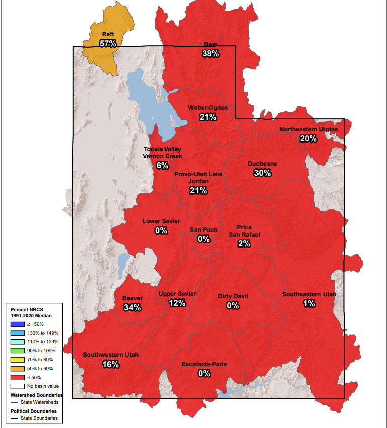
This is welcome news for the ski areas that have managed to remain open, but the late season storms won’t be enough to alleviate the damage that has already been done to the current remaining snowpack.
Statewide, the snowpack remains at just 20 percent of the most recent 30-year normal, with most drainages surrounding the Wasatch at about 30% or below, according to SNOTEL data from the USDA – NRCS.
The official National Weather Service monitoring station at the Salt Lake City International Airport has broken the maximum high temperature record seven times in March alone.
Extended Outlook
High-pressure looks to build back into the West by the weekend and throughout early next week, with seasonal temperatures quickly returning.
By: Adam Lenkowski

2475 W White Pine Lane
Park City, UT 84060
2154 S Rio Verde
Moab, UT 84532
137 W Bridlewood Lane
Midway, UT 84049
2400 E Walker Lane
Holladay, UT 84117Talk of the Town


Park City Jobs

General Manager - Wine Bar & Kitchen, Tannin Bar
Today Full time $75,000 - $95,000 yearly
Associate HOA Manager - Full Time, Sea to Ski Property Management
2 days ago Full time

Dog Walker, wagging tails on the trails
4 days ago Part time $20.00 - $25.00 hourly

Architect/Architectural Designer, Vera Iconica Architecture
6 days ago Full time $60,000 - $95,000 yearly