Weather
Weekend dumpage gives snowpack a slight boost
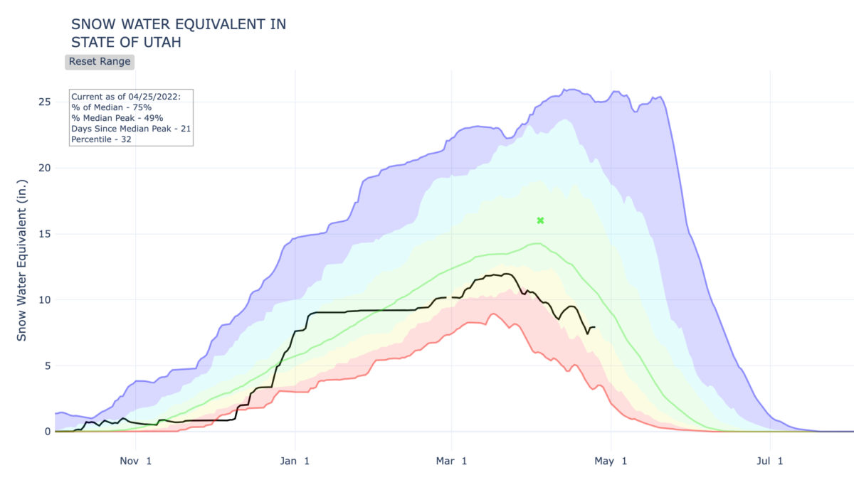
The black line represents the current water year. Photo: USDA
PARK CITY, Utah — While Park City only saw a light dusting this weekend, Alta reported over 30 inches of snow, and Brighton and Solitude in Big Cottonwood Canyon both saw 18 inches.
View this post on Instagram
Every little bit helps given Utah’s drought and the state’s snow water equivalent increased by half an inch over the weekend. Snowpack now sits at 75% when compared to the historical median.
Anyone lose a Ford?
We found it. pic.twitter.com/QcpdwBcB2O— Alta Marshal (@MarshalMike1) April 23, 2022
High pressure will bring a warming trend to Utah through Tuesday. Highs will be near seasonal normals, warming to up to 10°F above normal by Tuesday, according to the National Weather Service in Salt Lake City.
Park City forecast for this week:
Monday night
Partly cloudy, with a low around 35. South wind 10 to 13 mph.
Tuesday
Partly sunny, with a high near 56. South wind 14 to 17 mph.
Tuesday night
Mostly cloudy, with a low around 39. South southwest wind 11 to 17 mph becoming southeast after midnight.
Wednesday
A 20 percent chance of showers after noon. Mostly sunny, with a high near 56. East southeast wind 10 to 14 mph becoming west southwest in the afternoon.
Wednesday night
Partly cloudy, with a low around 38.
Thursday
Partly sunny, with a high near 59.
Thursday night
A slight chance of rain showers before midnight, then a chance of rain and snow showers between midnight and 3am, then a chance of snow showers after 3am. Mostly cloudy, with a low around 34.
Friday
A chance of snow showers. Partly sunny, with a high near 41.
Friday night
Mostly clear, with a low around 28.
Saturday
Mostly sunny, with a high near 48.
Saturday night
Partly cloudy, with a low around 33.
Sunday
Mostly sunny, with a high near 53.
Drought continues to impact our state & some areas are implementing restrictions, so be sure to check with your local water provider. These weekly watering guides are posted at @UTAHSavesH2O‘s website on Thursdays: https://t.co/y7DncAJwXc #slowtheflow #wait2water #utah pic.twitter.com/ARaONHeGqo
— Utah DNR (@UtahDNR) April 25, 2022
By: TownLift

2154 S Rio Verde
Moab, UT 84532
2400 E Walker Lane
Holladay, UT 84117
137 W Bridlewood Lane
Midway, UT 84049
2475 W White Pine Lane
Park City, UT 84060Talk of the Town


Park City Jobs

Sommet Blanc Senior Technician, Diversified Property Services
2 days ago Full time
Resident Manager - Empire Residences, Diversified Property Services
2 days ago Full time $60,000 - $65,000 yearly
Chiropractic Front Desk/Therapy Assistant, Lundstrom Chiropractic
4 days ago Part time $21.50 hourly
Maintenance Tech, Park City Rental Properties
5 days ago Full time $22.00 - $25.00 hourly

Love Fashion, Creativity & Artisan Goods? Join the Blue Sky Nomads Team, Blue Sky Nomads
8 days ago Part time $18.00 - $25.00 hourly