Environment
Flood Watch covers Summit County as monsoon storms move into Utah

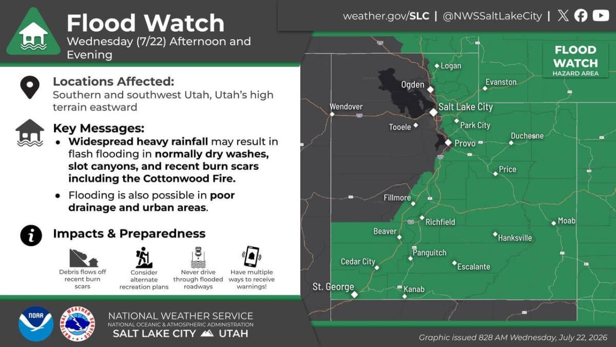
Much of southern, central, and northeastern Utah is under a flood watch Wednesday. Photo:
PARK CITY, Utah — The National Weather Service has issued a Flash Flood Watch for much of Utah, including Summit County and surrounding mountain areas, from noon through Wednesday evening as monsoon thunderstorms are expected to bring periods of heavy rain and the potential for dangerous flash flooding.
Saturday evening, heavy rain flooded the Poison Creek Trail and brought mud and debris down Swede Alley, and Tuesday evening over half an inch of rain fell in Pinebrook, the second highest total in the state for the day.
Forecasters say slow-moving thunderstorms could produce intense rainfall in a short amount of time, creating hazardous conditions even in areas that don’t receive rain directly.
Flood risk is greatest in normally dry washes and drainages, slot canyons and slickrock terrain, campgrounds near creeks and rivers, low-lying roads and flood-prone areas, and recent wildfire burn scars.
Burn scars of particular concern across Utah include the Cottonwood, Silver King, Monroe Canyon, France Canyon, and Forsyth fires, where vegetation loss allows water, mud, and debris to move downhill quickly.
Officials also caution that flash flooding can occur far from where rain is falling. Heavy downpours upstream can send walls of water rushing through creeks, washes, and canyons with little warning.
The watch comes just days after heavy monsoon storms triggered flooding and mudslides in central Utah, temporarily closing Interstate 15 near Beaver and washing out portions of state Route 153 through Beaver Canyon.
With many residents and visitors expected to be hiking, camping, and recreating outdoors, emergency officials are urging people to stay weather aware and reconsider plans in flood-prone areas if thunderstorms develop.
How to stay safe
The National Weather Service recommends taking the following precautions:
- Never drive through flooded roads. Just 6 inches of moving water can knock an adult off their feet, while 12 inches can carry away most vehicles.
- Monitor weather conditions if you’re hiking, camping, off-roading or spending time outdoors.
- Move to higher ground immediately if water begins rising or a Flash Flood Warning is issued.
- Have multiple ways to receive weather alerts, especially in areas with limited cell service.
- Avoid camping in washes, creek beds or other low-lying areas that can flood rapidly.
- Keep children and pets away from flooded waterways, where currents are often stronger than they appear.
A Flash Flood Watch means conditions are favorable for flash flooding to develop but does not mean flooding is already occurring. Residents are encouraged to monitor forecasts throughout the day and be prepared to change plans if conditions deteriorate.
Even if skies are clear overhead, flooding can develop in minutes from storms miles away.
By: Heather Bergeson


4539 S Willow Road
Holladay, UT 84117
10584 Basin Canyon Road
Park City, UT 84098
24 South 600 East
Salt Lake City, UT 84102
965 Goshen Canyon Road
Mona, UT 84645
19 East 100 North
Spring City, UT 84662Talk of the Town


Park City Jobs

Hiring Barista Assistants and Baristas, Silver King Coffee
2 days ago Part time $17.00 - $30.00 hourly

Logistics Specialist, PACIFICORP
3 days ago Full time $28.70 - $28.71 hourly

Soccer Coach August Through October (Mon–Thu 3:45pm–5:15pm), City League PC
3 days ago Contractor $25.00 hourly

General Manager - Wine Bar & Kitchen, Tannin Bar
8 days ago Full time $75,000 - $95,000 yearly

Associate HOA Manager - Full Time, Sea to Ski Property Management
10 days ago Full time