News
Wednesday was nearly the largest 24-hour temperature drop on record
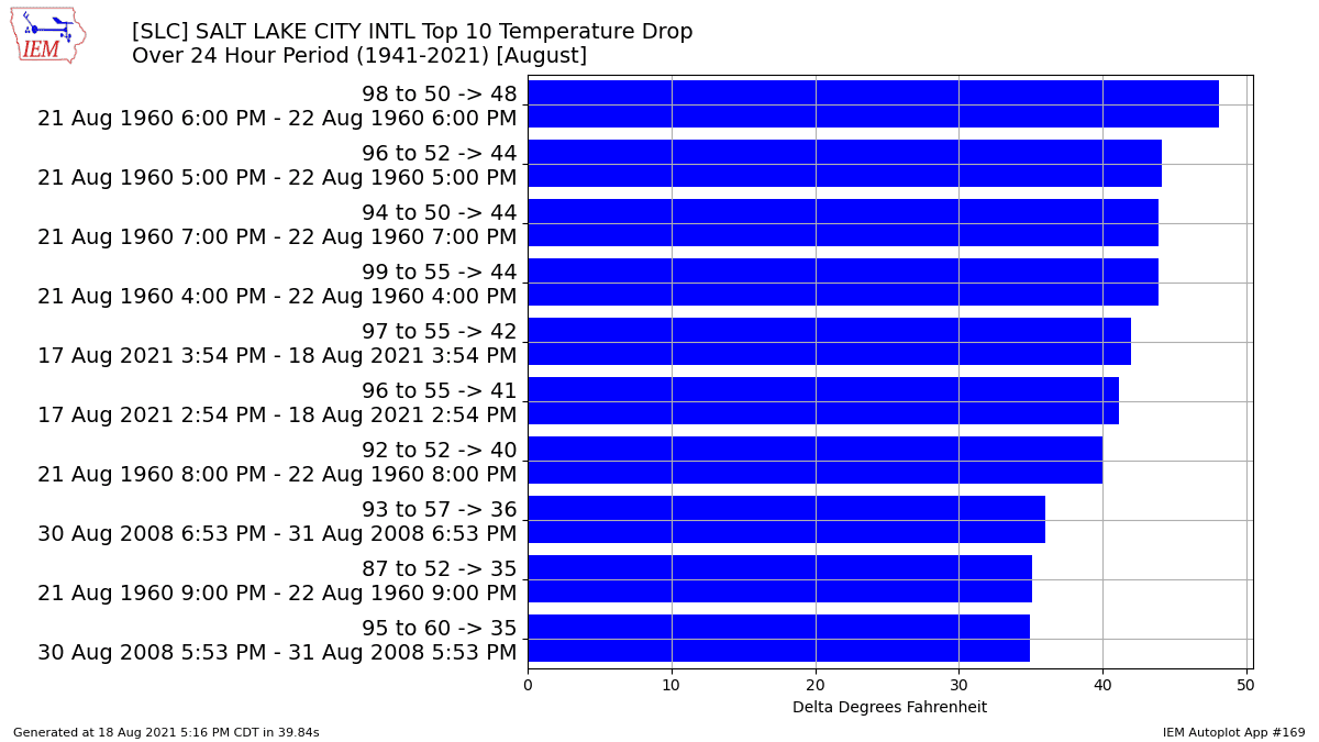
The temperature dropped 42 degrees between Tuesday and Wednesday. Photo: National Weather Service
SALT LAKE CITY — Data released this week shows that from mid-afternoon Tuesday, August 17, to mid-afternoon Wednesday, August 18, the temperature dropped from 97 degrees Fahrenheit to 55 degrees.
That was nearly the largest 24-hour drop on record at the Salt Lake City National Weather Service (NWS) Office.
The shift in weather shocked many, bringing even snow to high elevation areas.
More reports of high elevation snow from this morning! #utwx https://t.co/xzPDX30uEJ
— NWS Salt Lake City (@NWSSaltLakeCity) August 19, 2021
This weekend’s temperature appears to be more stable, however smoke will remain in the area.
The NWS said to expect modest smoke concentrations throughout Friday, while southwesterly flow will move surface-level smoke throughout the day.
“This should make for better surface air quality for outdoor recreation (except far northwest UT),” NWS said in a tweet referring to the weather Saturday.
Unfortunately, Sunday will likely bring increasing smoke, mostly in northern Utah.
NWS said the smoke might actually be worse in the mountains compared to the valleys.
7/9 Again looking at a cross section Sunday morning, we can see smoke thickens down to mountain top level first, with slightly less in the valleys. pic.twitter.com/FaKb8Th5tp
— NWS Salt Lake City (@NWSSaltLakeCity) August 20, 2021
By: TownLift

2549 W Sinagua Trail, #26
St. George, UT 84770
5497 S Walker Estates Circle
Holladay, UT 84117
1198 E Elkhorn Lane
Oakley, UT 84055
5314 W Rolling Brook Drive
Herriman, UT 84096
7020 E Creekside Road
Castle Valley, UT 84532Talk of the Town


Park City Jobs
Senior Development Manager, Park City Education Foundation
1 day ago Full time $70,000 yearly
Development Associate, Park City Education Foundation
1 day ago Full time $46,000 yearly
Stio Mountain Studio Associate Manager, Stio
2 days ago Full time $50,000 - $60,000 yearly
Pharmacist, Alpine Apothecary
5 days ago Part time

Dental Assistant, Rise Dental Wellness
5 days ago Part time