Weather
Winter Storms Shatter Records in the Wasatch
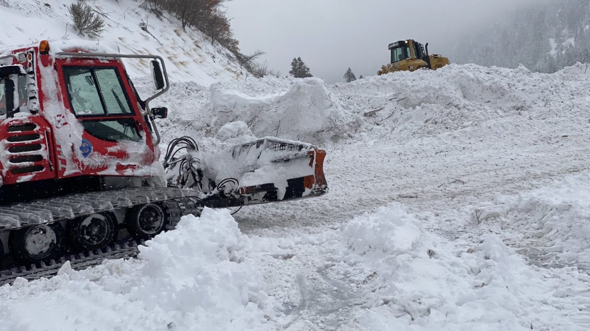
Little Cottonwood Canyon's SR-210 remains closed, according to UDOT: "Historic avalanche activity w/ slides across road in multiple locations." Photo: Courtesy of UDOT
SALT LAKE CITY, Utah. — Better late than never: winter has finally arrived, with snow totals varying from 16 inches at Nordic Valley to 101 inches at Alta falling during this Feb. 12 – Feb. 18 storm cycle. The U.S. National Weather Service reported that multiple snowfall records were broken yesterday.
Daily snowfall recordings are made at the Salt Lake City airport beginning at midnight. The previous record of 7.6 inches of daily snowfall on Feb. 17 was set in 1926. Yesterday’s snowfall crushed that after hitting 11.7 inches. The all-time one-day snowfall record for February was also broken yesterday. The previous record was 10.9 inches on Feb. 1, 1989.
While mountains of powder are a thrilling sight for both outdoor sports lovers and anyone worried about Utah’s current drought conditions, this much snow in such a short span of time is not without significant challenges to safety, transportation, and general snow-removal logistics.
As of 11 a.m., Little Cottonwood Canyon’s SR-210 remained closed, according to the UDOT Cottonwoods Twitter accounts. UDOT posted a warning about “historic avalanche activity w/ slides across road in multiple locations.” UDOT also said at 11:41 a.m. that uphill traffic through Big Cottonwood Canyon SR-190 was being restricted due to congestion, and cars are being turned around at Cardiff Fork (milepost 10.5).
Today’s avalanche forecast, according to the Utah Avalanche Center, indicates the Salt Lake Mountains are at the “Considerable” and “High” levels. The U.S. Forest Service of the Uinta and Wasatch Mountains offered the following tips:
- “Know before you go” and check the avalanche forecast, thinking about impassable roads, checking the weather forecast to choose the right gear and equipment
- “Recreate with respect” by wearing masks, maintaining physical distance from other recreators, leashing pets, and practicing Leave No Trace or “LNT” methods by packing out waste
- “Plan your route in advance” to avoid crowds and have a plan before recreating
- “Keep in touch” by letting someone know whereabouts and what time to anticipate a return
- “Play it safe” by knowing physical limits and having the necessary gear to reduce risk for injury
In addition, stock homes and cars with bottled water, warm blankets, and food in case of interlodge or traffic delays or emergencies.
Staying home is a valid option at the moment given the avalanche risk in backcountry and mountainous areas. But indoors requires safety considerations as well. Homeowners and renters should have carbon monoxide alarms placed throughout homes and office spaces to avoid the silent killer of carbon monoxide poisoning, which can occur when using faulty space heaters, or when exhaust vents are blocked (in cars or buildings) by snow. and during a powder-chasing day to the Cottonwoods.
Even for the most powder-hungry in the crowd, sometimes Mother Nature serves up a little too much. On the topic of record-breaking, Alta broke the longest interlodge record when the ski area reported being under lockdown for 60 hours (and counting) as of 10:46 a.m today. The previous record for interlodge at Alta was 52 hours, which occurred last ski season.
Evan Thayer, Utah Snow Forecaster for OpenSnow.com, published a blog post from the Town of Alta this morning: “Just waking up from night #3 of interlodge. Huge thanks to my friends at Conskierge for providing me shelter during this storm. At this point, I have very little interest in skiing powder. I am just hoping to get down the canyon this morning so I can see my wife and 5-month-old son.”
🚧 #RoadClosureUpdate 🚧 #SR210 remains CLOSED. @udotavy mitigation continues, extensive debris clean up by @utahdot road ops to follow.
Historic avalanche activity w/ slides across road in multiple locations.
No est time of opening. Be patient, we will update ASAP. pic.twitter.com/OUSPcSOYHC
— UDOT Cottonwood Canyons (@UDOTcottonwoods) February 18, 2021
By: Bailey Edelstein

597 Deer Valley Loop Road
Park City, UT 84060
2475 W White Pine Lane
Park City, UT 84060
137 W Bridlewood Lane
Midway, UT 84049
2400 E Walker Lane
Holladay, UT 84117
2154 S Rio Verde
Moab, UT 84532Talk of the Town


Park City Jobs

Chef de Cuisine, Washington School House Hotel
Today Full time $50,000 - $60,000 yearly
Housekeeper, Washington School House Hotel
Today Full time $20.00 - $22.00 hourly
Line Cook, Washington School House Hotel
Today Full time $20.00 - $22.00 hourly
Ski Patrol Medical & Rescue Technician, Utah Olympic Park
1 day ago Full time $22.00 hourly
Full or Part Time Dishwasher/Prep Cook, Rebekah's Kitchen
3 days ago Part time $13.00 - $18.00 hourly