Community
Utah’s Division of Natural Resources makes wildfire risk map easier to use for property owners
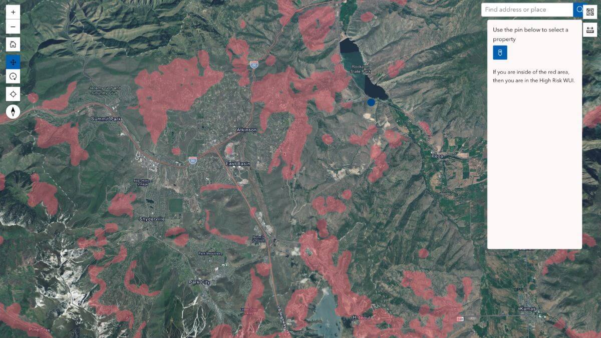
Newly released High Risk Wildland Urban Interface properties map. Photo: Screenshot from the Utah Division of Natural Resources
PARK CITY, Utah — Utah’s Division of Natural Resources has developed a new interactive map for property owners to see whether their home falls within the Utah High Risk Wildland Urban Interface (WUI).
The state first finalized a map identifying which properties fall within high-risk wildfire zones in December, but received feedback from users that the maps were difficult to navigate, according to Utah Fire.
The new map allows users to zoom in and select their property to check whether it is included in a high-risk WUI designated area.
The High Risk Wildland Urban Interface (WUI) defines geographical areas across the state where human development, structures, and infrastructure exist alongside undeveloped wildland vegetation. These are areas where fuels and ember loads in combination with structure density create significant fire risk.
Property owners in these areas will be subject to a $20-100 fee in 2026-27 depending on the square footage of any taxable structures on the property. In future years, fees will be based on triage assessment and square footage of taxable structures.
Fees will not be charged on vacant land and will be used to fund Utah’s new Wildfire Preparedness Program.
By: Heather Bergeson

4539 S Willow Road
Holladay, UT 84117
19 East 100 North
Spring City, UT 84662
24 South 600 East
Salt Lake City, UT 84102
10584 Basin Canyon Road
Park City, UT 84098
965 Goshen Canyon Road
Mona, UT 84645Talk of the Town


Park City Jobs

Hiring Barista Assistants and Baristas, Silver King Coffee
2 days ago Part time $17.00 - $30.00 hourly

Logistics Specialist, PACIFICORP
3 days ago Full time $28.70 - $28.71 hourly
Soccer Coach August Through October (Mon–Thu 3:45pm–5:15pm), City League PC
3 days ago Contractor $25.00 hourly

General Manager - Wine Bar & Kitchen, Tannin Bar
8 days ago Full time $75,000 - $95,000 yearly
Associate HOA Manager - Full Time, Sea to Ski Property Management
10 days ago Full time