Weather
Park City’s snowpack to deepen with forecast of 12+ inches of fresh snow
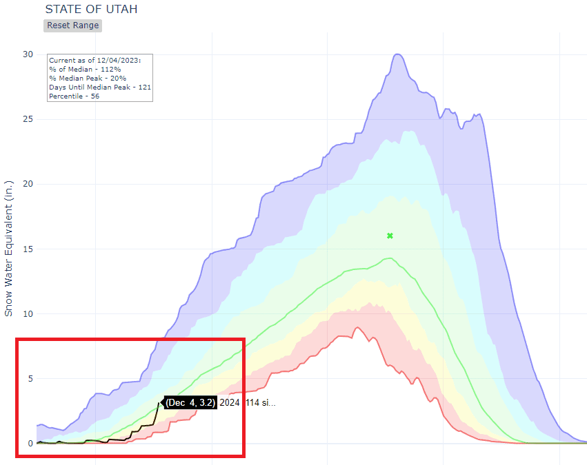
Utah snow water equivalent as of Dec 6. 2023. Photo: USDA
The next system is slated to move into the area on Thursday afternoon with HEAVY snow predicted on Friday, Dec 8. Forecast totals at Park City Mountains are between 12″ and 14″ of snow through Saturday, Dec. 9.
PARK CITY, Utah — This past weekend’s storm cycle brought the Utah statewide snow water equivalent (i.e. the snowpack) up to around average. The storm delivered some impressive snow and water totals this past weekend with Upper Cottonwoods seeing 40-50” snow (3.52-5.03” water) and the Park City Ridgeline seeing 20-30” snow (1.80-2.58” water).
The next system is slated to move into the area on Thursday afternoon with HEAVY snow predicted on Friday, Dec 8. Forecast totals at Park City Mountains are between 12″ and 14″ of snow through Saturday, according to the National Weather Service.
Thursday Night
Snow, mainly after midnight. Low around 21. Northwest wind 5 to 7 mph becoming south southeast after midnight. Chance of precipitation is 80%. New snow accumulation of 1 to 3 inches possible.
Friday
Snow. The snow could be heavy at times. High near 28. West northwest wind 6 to 13 mph. Chance of precipitation is 100%. New snow accumulation of 5 to 9 inches possible.
Friday Night
A 50 percent chance of snow. Mostly cloudy, with a low around 11. New snow accumulation of around an inch possible.
Utah Ski Resort Forecast Snow Totals Through Saturday Dec. 9
| Low End Snowfall | Expected Snowfall | High End Snowfall | |
| Alta Ski Area, UT | 12 | 22 | 22 |
| Beaver Mountain, UT | 5 | 9 | 10 |
| Brian Head Resort, UT | 0 | 3 | 4 |
| Brighton Resort, UT | 10 | 19 | 20 |
| Canyons Village, UT | 10 | 17 | 18 |
| Cherry Peak Resort, UT | 3 | 7 | 8 |
| Deer Valley, UT | 8 | 12 | 16 |
| Eagle Point Resort, UT | 4 | 9 | 10 |
| Nordic Valley, UT | 3 | 6 | 7 |
| Park City Mountain Resort, UT | 8 | 14 | 16 |
| Powder Mountain, UT | 4 | 7 | 9 |
| Snowbasin Resort, UT | 5 | 10 | 12 |
| Snowbird Ski and Summer Resort, UT | 10 | 19 | 21 |
| Solitude Mountain Resort, UT | 12 | 20 | 21 |
| Sundance Mountain Resort, UT | 5 | 10 | 12 |
Get Our First Chair Snow Report Email
TownLift is excited to introduce our new email newsletter, First Chair. Designed to kickstart your day, First Chair delivers a concise summary of snowfall, weather, and the latest news.
This email won’t flood your inbox daily; instead, subscribers can expect to receive First Chair around 7 a.m. on days when there’s significant snowfall (6 inches or more) or when there’s noteworthy news to share. Check out a first chair email here.
Interested in joining? Opt into First Chair here or via the form below. We aim to add value to your mornings and welcome any suggestions you may have.
By: TownLift

597 Deer Valley Loop Road
Park City, UT 84060
2400 E Walker Lane
Holladay, UT 84117
2475 W White Pine Lane
Park City, UT 84060
2154 S Rio Verde
Moab, UT 84532
137 W Bridlewood Lane
Midway, UT 84049Talk of the Town


Park City Jobs

Chef de Cuisine, Washington School House Hotel
1 day ago Full time $50,000 - $60,000 yearly
Housekeeper, Washington School House Hotel
1 day ago Full time $20.00 - $22.00 hourly
Line Cook, Washington School House Hotel
1 day ago Full time $20.00 - $22.00 hourly
Ski Patrol Medical & Rescue Technician, Utah Olympic Park
2 days ago Full time $22.00 hourly
Full or Part Time Dishwasher/Prep Cook, Rebekah's Kitchen
4 days ago Part time $13.00 - $18.00 hourly