NOAA winter outlook puts northern Utah on the drier side

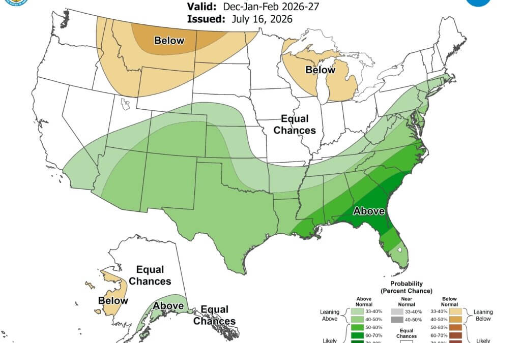
The agency’s December-through-February forecast favors below-normal precipitation across parts of the northern Rockies, while southern Utah leans wetter.
PARK CITY, Utah — Utah could see a warmer-than-normal winter as a strengthening El Niño shapes weather patterns across the country, according to the National Weather Service’s Climate Prediction Center.
In its seasonal outlook issued July 16, the Climate Prediction Center said El Niño is expected to intensify through the end of 2026 and continue into early 2027. The center placed the probability of a very strong El Niño between October and December at 81%.
The Climate Prediction Center said the developing pattern is expected to favor warmer-than-normal temperatures across much of the western and northern United States during the 2026-27 winter.
Utah is included in the area where NOAA favors above-normal temperatures during the core winter months of December, January and February. That designation means warmer conditions are more likely than cooler or near-normal conditions across the three months.
The precipitation outlook is less definitive for northern Utah.
The Climate Prediction Center said winter precipitation patterns are expected to become increasingly characteristic of El Niño, with below-normal precipitation favored from the Pacific Northwest into portions of the central Plains and above-normal precipitation favored across the southern tier of the country.
NOAA’s outlook maps place northern Utah and the Wasatch Back near the transition between those two patterns.
The Climate Prediction Center does indicate a weak tilt toward below-normal precipitation across portions of the central West during some winter outlook periods. The agency said that pattern is consistent with the expected influence of El Niño, but forecast probabilities remain relatively modest.
The Climate Prediction Center said even the strongest El Niño events do not produce typical effects in every location. A stronger event can increase the likelihood of certain broad weather patterns, but individual storms and shorter-term atmospheric conditions ultimately determine local snowfall.
El Niño occurs when unusually warm ocean temperatures in the central and eastern equatorial Pacific interact with the atmosphere and alter weather patterns around the world.
The Climate Prediction Center said its seasonal forecasts incorporate several computer models, historical El Niño patterns, sea-surface temperatures, soil moisture and longer-term temperature and precipitation trends.


4251 E Lipizzan Jump
Moab, UT 84532