Weather
Farmers’ Almanac predicts snow, cold snaps and shifting conditions for the 2026-27 winter season

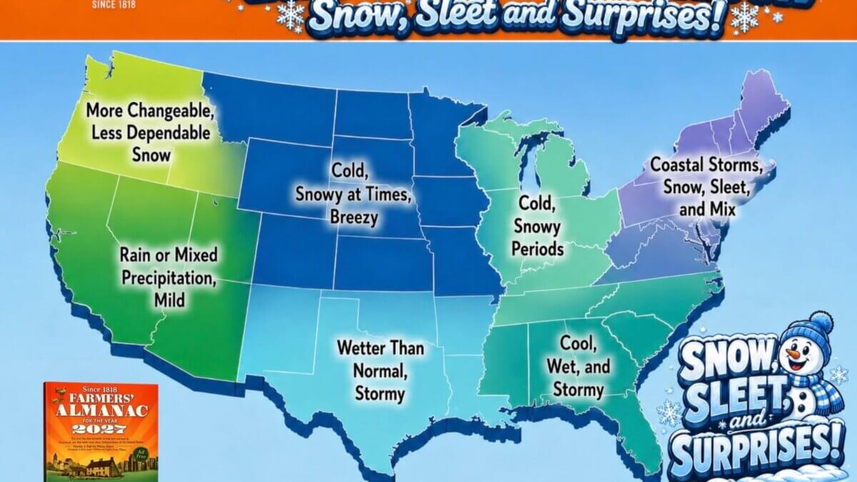
Winter 2026-27 Farmers' Almanac prediction Photo: Farmers Almanac
The 2026-27 outlook calls for an active southern storm track and near-normal temperatures interrupted by periods of snow and cold
PARK CITY, Utah — The West could see a changeable winter marked by sudden cold snaps, brief snowy periods and stretches of milder weather, according to the Farmers’ Almanac’s newly released forecast for winter 2026-27.
The Farmers’ Almanac forecast, updated Aug. 13, predicts a season of sharp contrasts across the United States. The publication expects an active southern storm track to bring above-normal precipitation from California and the Southwest east through Texas, the Gulf Coast and the Southeast.
The Farmers’ Almanac said El Niño is expected to remain an important influence through the heart of the season, favoring wetter-than-normal conditions across much of the southern United States. The southern Rocky Mountains could benefit from increased mountain snowfall when cold air meets moisture moving along the storm track.
For much of the West, temperatures are expected to average near normal overall. However, the Farmers’ Almanac cautioned that the seasonal average does not mean consistently mild weather. Frequent milder stretches could break up fast-moving storms, sudden cold snaps, and short periods of snow.
The outlook does not include a specific snowfall or temperature projection for Park City. Instead, it describes broad patterns across large regions, meaning local conditions in the Wasatch Mountains could differ from the overall forecast.
The Pacific Northwest may experience a more changeable and less dependable snow season, according to the Farmers’ Almanac. Farther east, the northern Plains, Upper Midwest and Great Lakes could see quick-moving storms, snow squalls, blustery winds and brief periods of bitter cold.
The Farmers’ Almanac expects the most persistent storm activity along the southern tier of the country. An active storm path could carry weather systems from Southern California and the Desert Southwest through Texas and the Southeast, bringing periods of rain and occasional surges of cold air.
Where colder air meets the added moisture, some storms could produce sleet, freezing rain, or heavy, wet snow, the Farmers’ Almanac said.
The Northeast could experience one of the country’s most complicated winter patterns. Coastal areas may receive more rain or mixed precipitation, while inland communities could see several rounds of heavy, wet snow, particularly in January and February.
The Farmers’ Almanac has published long-range weather predictions since 1818. According to the publication, its proprietary forecasting method considers recurring natural cycles, solar activity, lunar influences and historical weather patterns. The Farmers’ Almanac said those traditional calculations are now supplemented with satellite observations, computer modeling, current meteorological data, and analysis of large-scale ocean and atmospheric patterns.
The publication does not disclose the complete forecasting formula.
The outlook is intended to identify broad seasonal patterns rather than predict the timing or severity of individual storms. For Park City and the surrounding Wasatch Mountains, snowfall will ultimately depend on the paths, temperatures, and moisture associated with individual weather systems.
By: Rebecca Brenner


2266 E Garfield Avenue
Salt Lake City, UT 84108
5758 Cobalt Circle
Park City, UT 84098
4251 E Lipizzan Jump
Moab, UT 84532
733 Summit Way
Alpine, UT 84004Talk of the Town


Park City Jobs

Hiring Barista Assistants and Baristas, Silver King Coffee
4 days ago Part time $17.00 - $30.00 hourly

HOA On-Site Supervisor, All Seasons HOA Management
6 days ago Full time $65,000 - $70,000 yearly

Buildings and Grounds Maintenance Technician, National Ability Center
7 days ago Full time $23.00 - $27.00 hourly
Lodge and Hospitality Coordinator, National Ability Center
7 days ago Full time $22.00 hourly
Reservations Coordinator, National Ability Center
7 days ago Full time $22.00 hourly