Weather
Don’t sleep on this one: a multi-day system could reset the mountain with 9–14 inches by Friday
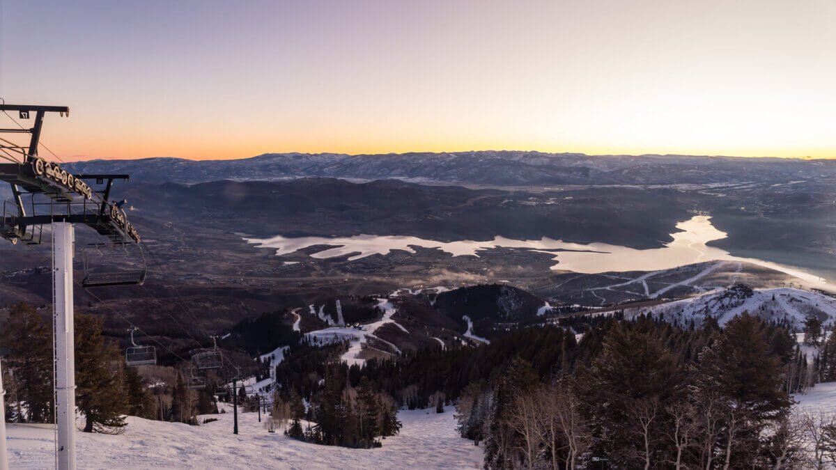
Deer Valley overlooking the Jordanelle reservoir on March 4, 2026 Photo: Deer Valley Resort
A multi-day winter system is set to bring meaningful snowfall to the Wasatch Back starting tonight, with mountain totals looking promising for the resorts.
PARK CITY, Utah — Enjoy the sunshine today while it lasts. Park City is sitting pretty with a high near 45 and clear skies Wednesday, but that changes fast. Snow moves in tonight after 8 p.m., and by Thursday morning a cold front moves in bringing heavy snowfall to local resorts.
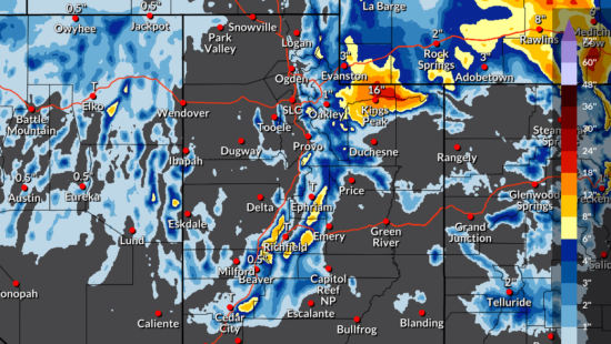
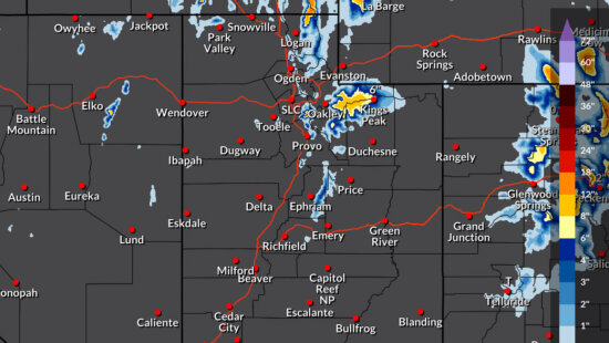
The National Weather Service has issued a Winter Weather Advisory for the Wasatch Back, including Park City, running from 2 a.m. Thursday through 5 p.m. Friday. Parkites could see : 3 to 7 inches in town, with locally higher amounts up to 10 inches possible in the Park City area mountains.
Here’s how the storm plays out day by day:
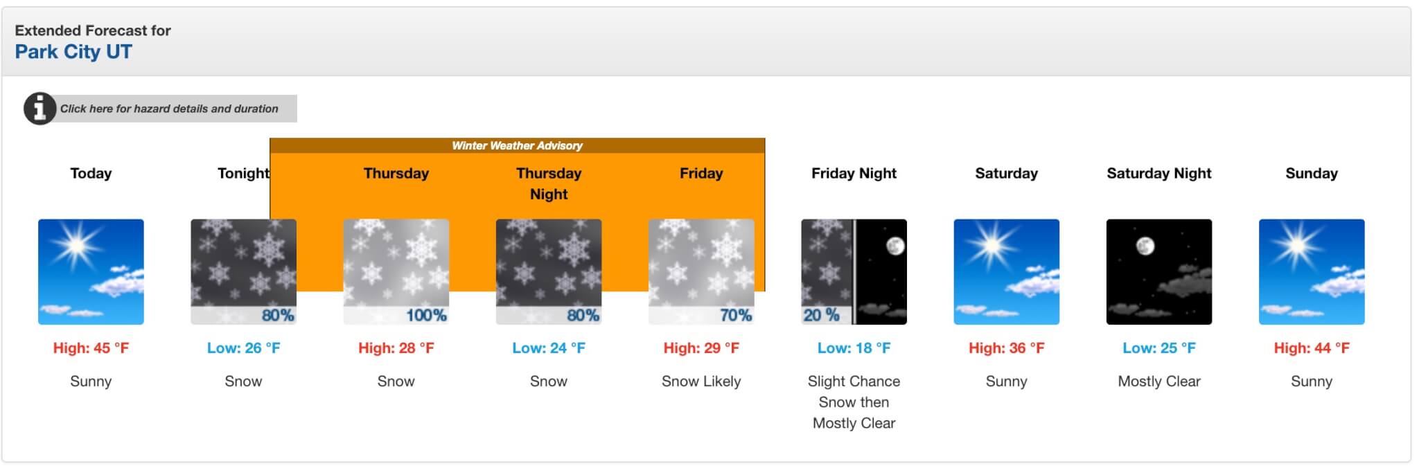
In town, snow develops after 8 p.m. tonight with around an inch of accumulation possible before sunrise. Lows drop to around 26. Thursday is the main event, with snow all day (100% chance of precipitation), a high of only 28, and 2 to 4 inches of new snow expected in town. Thursday night keeps the snow going, adding another 1 to 3 inches with lows near 24. Friday offers one more round, with snow likely and 1 to 2 additional inches before the storm wraps up by Friday evening.
Saturday and Sunday look beautiful, sunny and clearing, which means a packed powder weekend on the mountain for anyone who can hold out.
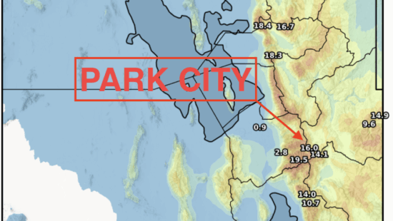
Resort Snow Totals Through Friday March 6
| Resort | Low | Medium | High |
|---|---|---|---|
| Alta | 3″ | 14″ | 19″ |
| Snowbird | 3″ | 14″ | 19″ |
| Park City Mountain | 3″ | 9″ | 15″ |
| Canyons Village | 3″ | 10″ | 16″ |
| Deer Valley | 2″ | 7″ | 14″ |
Alta and Snowbird are showing the highest upside potential, with mid-range forecasts near 14 inches. Park City Mountain and Canyons are in the 9 to 10 inch median range, and Deer Valley sits a bit lower but still has a high-end scenario north of a foot.
A note for anyone driving Parley’s: The NWS specifically calls out Parley’s Canyon (I-80) as a concern for Thursday morning’s commute, when the heaviest snowfall is expected to coincide with rush hour. Plan accordingly if you’re heading into Salt Lake.
A lull is expected Thursday afternoon, then wrap-around moisture moves back in late Thursday into Friday morning for one more push before things clear out heading into the weekend.
By: TownLift

597 Deer Valley Loop Road
Park City, UT 84060
137 W Bridlewood Lane
Midway, UT 84049
2154 S Rio Verde
Moab, UT 84532
2400 E Walker Lane
Holladay, UT 84117
2475 W White Pine Lane
Park City, UT 84060Talk of the Town


Park City Jobs

Dog Walker, wagging tails on the trails
Today Part time $20.00 - $25.00 hourly

Architect/Architectural Designer, Vera Iconica Architecture
2 days ago Full time $60,000 - $95,000 yearly
Assistant Pit Master, Lush's BBQ
2 days ago Part time $20.00 - $25.00 hourly

Chef de Cuisine, Washington School House Hotel
3 days ago Full time $50,000 - $60,000 yearly