Environment
Hurricane Hilary forms off Mexico’s Pacific coast, could impact Utah weather
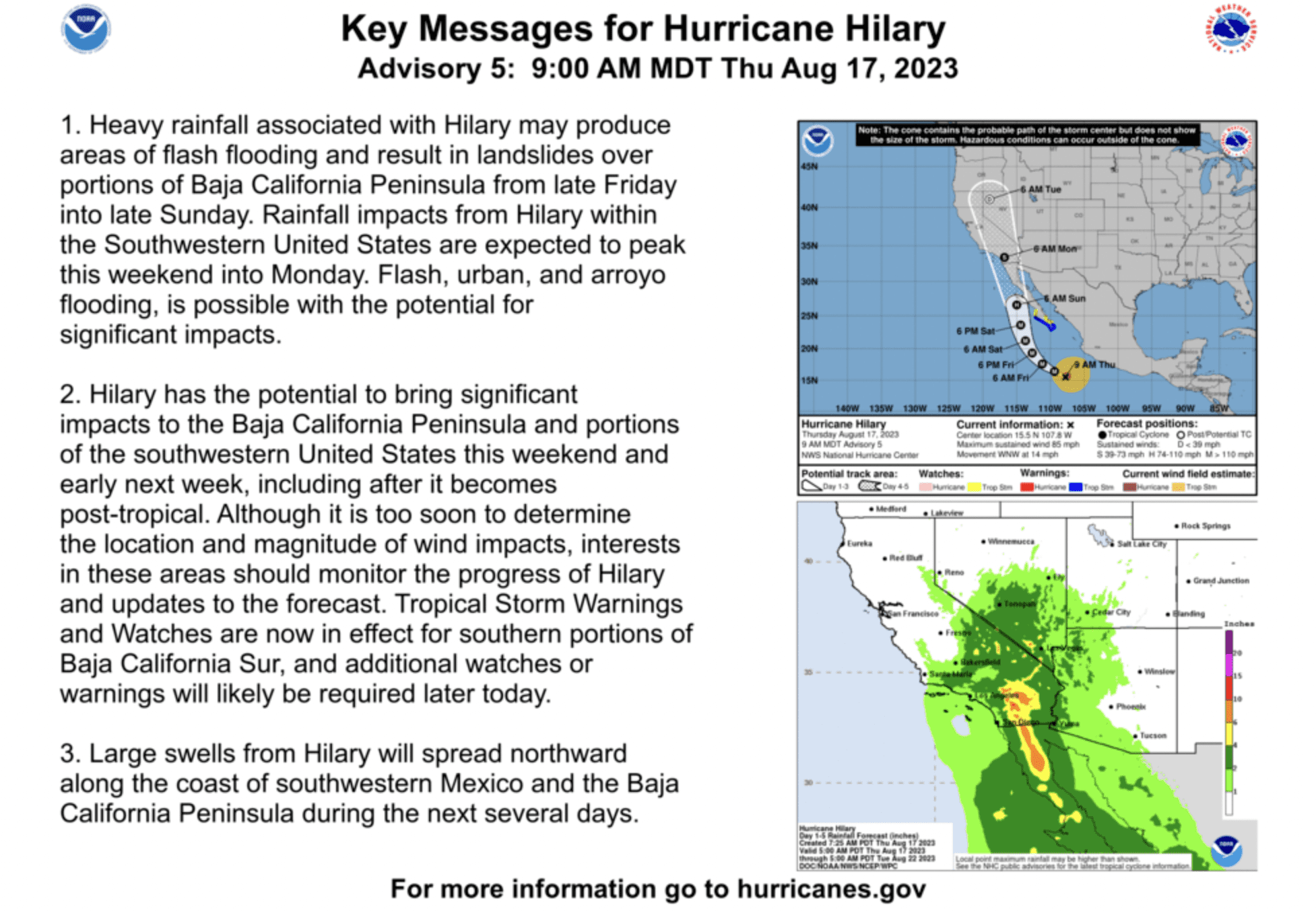
Day 1-5 excessive rainfall outlook for hurricane Hilary. August 17, 2023. Photo: National Hurricane Center
SALT LAKE CITY — A hurricane forming off of Mexico’s Pacific coast could have major impacts on Utah weather, although experts are still uncertain what those impacts will be.
Tropical Storm Hilary strengthened into a hurricane early Thursday off Mexico’s Pacific coast and it could become become a major hurricane as it keeps heading north over the ocean.
The U.S. National Hurricane Center said that Hilary had maximum winds of 75 mph (120 kph), and it was located 320 miles (515 kilometers) from the Mexican port city of Manzanillo, far from land.
The hurricane was moving at 13 mph (20 mph) west-northwest, and it was expected to become a major hurricane by Thursday night or early Friday as it moves toward the Baja peninsula, near the U.S. border.
“The bottom line is there is still a lot of uncertainty as to how this system will impact Utah and southwest Wyoming,” said a statement from the National Weather Service Salt Lake City. “There are two scenarios emerging, one with a westward track and one with an eastward track to the bulk of the moisture. A more westward track would favor less precipitation across the area, while a more eastward track would increase heavy rainfall probabilities across the area.”
The time between Saturday night and Monday is the most uncertain. For the latest information, visit https://www.nhc.noaa.gov/.
By: Associated Press

4539 S Willow Road
Holladay, UT 84117
19 East 100 North
Spring City, UT 84662
24 South 600 East
Salt Lake City, UT 84102
965 Goshen Canyon Road
Mona, UT 84645
10584 Basin Canyon Road
Park City, UT 84098Talk of the Town


Park City Jobs

Assistant Manager, LOMA
Today Full time $35.00 hourly
Property Inspector, Park City Rental Properties
1 day ago Full time $23.00 - $25.00 hourly
Owner Relations Manager, Park City Rental Properties
1 day ago Full time
Operations Manager, Park City Rental Properties
1 day ago Full time

Hiring Barista Assistants and Baristas, Silver King Coffee
3 days ago Part time $17.00 - $30.00 hourly