Weather
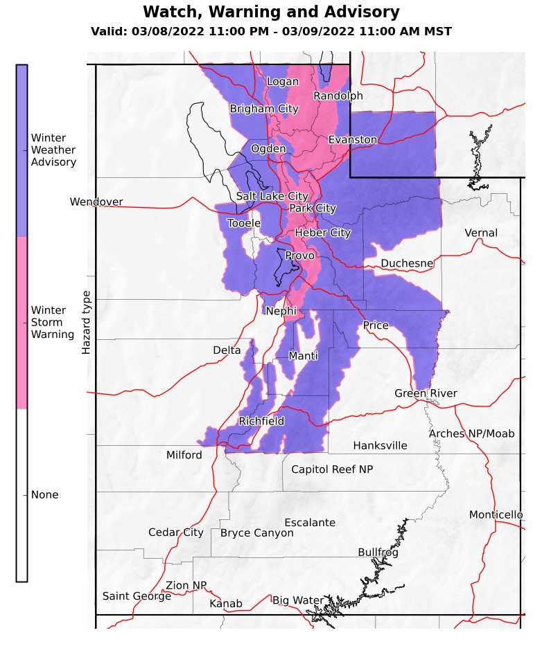
Winter storm warnings and advisories in effect in northern Utah on Tuesday

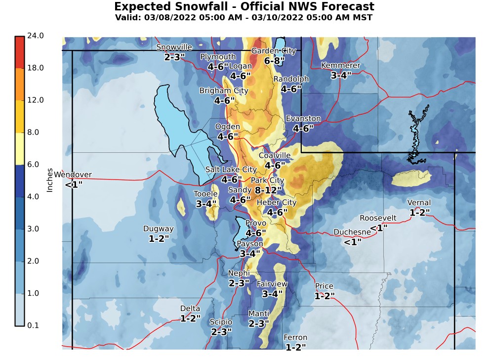
Park City could see 10 inches of fresh snow on Tuesday and Wednesday. Photo: TownLift
SUMMIT COUNTY, Utah — Winter storm warnings and advisories will go into effect for much of northern Utah Tuesday evening, according to the National Weather Service (NWS) in Salt Lake City.
“Impacts to travel are expected and you should take action if you plan on traveling, especially for travel on mountain summits/passes,” NWS said.
“For much of northern Utah, snow will arrive Tuesday morning or afternoon but pick up in intensity later in the evening/overnight.”
Park City forecast:
Monday night
Increasing clouds, with a low around 10. Wind chill values as low as -4. West wind 8 to 10 mph.
Tuesday
Snow likely, mainly after 2pm. Mostly cloudy, with a high near 25. West wind 7 to 11 mph. Chance of precipitation is 60%. New snow accumulation of 1 to 2 inches possible.
Tuesday night
Snow. Low around 21. Southwest wind 11 to 15 mph. Chance of precipitation is 90%. New snow accumulation of 3 to 5 inches possible.
Wednesday
Snow. High near 24. West northwest wind 14 to 17 mph. Chance of precipitation is 90%. New snow accumulation of 3 to 5 inches possible.
Wednesday night
A 40 percent chance of snow before 11pm. Mostly cloudy, with a low around 4. Northwest wind 9 to 15 mph. New snow accumulation of less than a half inch possible.
Thursday
A 20 percent chance of snow after 11am. Mostly sunny, with a high near 14.
Thursday night
Mostly clear, with a low around 3.
Friday
Sunny, with a high near 22.
Friday night
Mostly clear, with a low around 12.
Saturday
Sunny, with a high near 33.
Saturday night
Partly cloudy, with a low around 22.
Sunday
A slight chance of snow. Mostly sunny, with a high near 37.
Sunday night
Partly cloudy, with a low around 25.
Monday
Mostly sunny, with a high near 38.
—
TownLift Snow & Weather Report
Appreciate the coverage? Help keep Park City informed.
TownLift is powered by our community. If you value independent, local news that keeps Park City connected and in the know, consider supporting our newsroom.
By: TownLift

6110 E Blue Wing Loop
Kamas, UT 84036
3764 Prickly Pear Circle, Unit 5-A6
Moab, UT 84532
1545 N Red Castle Circle
Heber City, UT 84032
1042 W Shoreline Drive
Layton, UT 84041
2304 N Cohonina Trail
St. George, UT 84770
760 E Edgehill Rd
Salt Lake City, UT 84103Talk of the Town


Park City Jobs
Soccer Coach August Through October (Mon - Thu 3:15pm - 5:15pm), City League PC
Today Part time $25.00 hourly

Tour Guide & Driver Park City, Heber Valley &, Midway PT, Park City Travel and Tours LLC
1 day ago Contractor $15.00 - $18.00 hourly
Technician, Trails, Basin Recreation
1 day ago Full time $49,927 - $62,409 yearly
Education Coordinator and Summer Camp Manager , Kimball Art Center
1 day ago Full time $23.00 hourly

Digital Marketing Associate, Park City Community Foundation
4 days ago Contractor $24.00 - $27.00 hourly