Weather
After weeks of nothing, atmospheric river could dump 2 feet of snow or more on the Wasatch Mountains
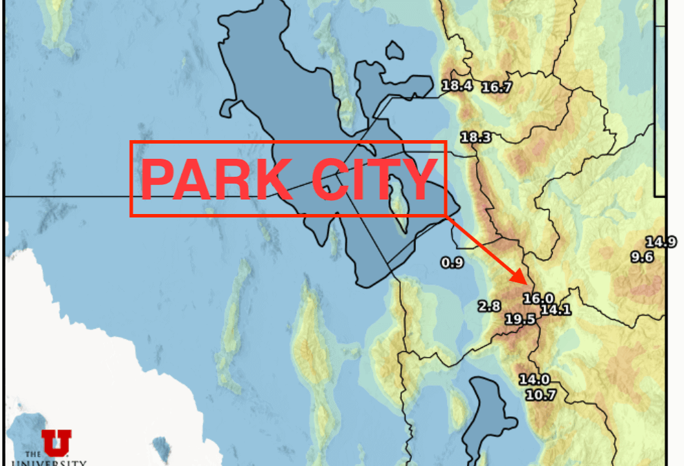
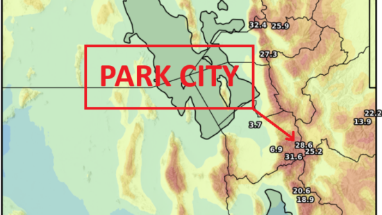
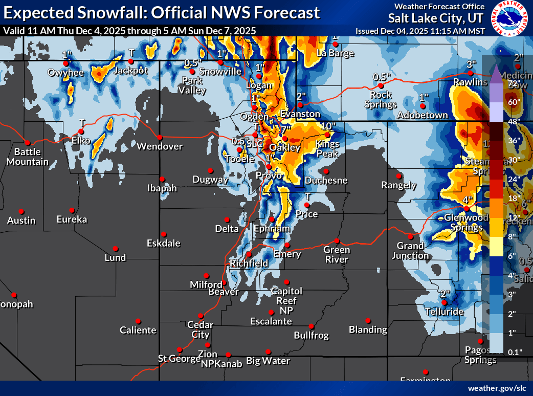
Photo: Utah Snow Ensemble model forecast total snowfall through Sunday // UofU Dept. of Atmospheric Sciences
Forecast Snow Totals Friday - Sunday morning: Cottonwood Canyons: 18 - 32”, PC Base/Town: 5 - 9”, Deer Valley/PCMR: 9 - 18”, N. Wasatch (Powder/Snowbasin): 12 - 24”
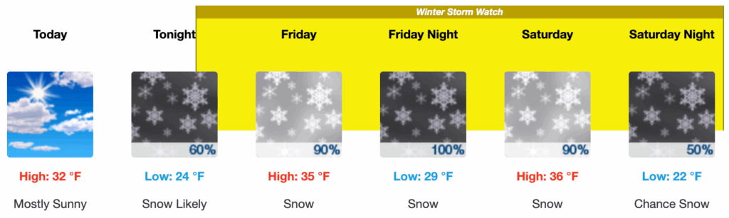
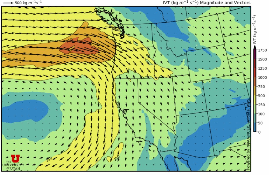
PARK CITY, Utah – It’s been a slow start to the 2025-2026 winter season, but this next storm cycle has the potential to finally get things going by providing some significant base building snowfall across northern Utah. The source is an atmospheric river type storm providing a surge of moisture laden air and very strong northwest winds, starting Thursday night and extending all the way away through early Sunday morning, potentially.
The leading edge of the moisture will reach us in earnest throughout the day Friday, with a few inches of snow expected in town and 4 – 8 inches in most of the Wasatch mountains. Things really start to ramp up Friday night as the strongest winds and heaviest precipitation begin, with gusts in the 70 mph range and generally 1 to 2 feet of snow across much of the Wasatch.
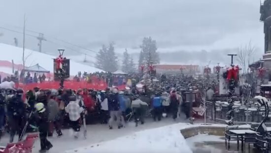
Deer Valley Resort will open to Pass Holders on Dec.5 and the public on Dec 6., Park City Mountain will open on Dec. 5
Be the first to know about how much snow Utah resorts get with the TownLift First Chair Email – Sign up Now.
Rising snow levels throughout this period may reach approximately 6500 feet by Saturday morning before colder air begins to filter in later in the evening as the last phase of the storm begins. Lighter snow showers are then expected to continue in favored areas as the winds return to a more true northwesterly direction, possibly into Sunday morning. Some weather models are calling for closer to 3 feet for upper Little Cottonwood Canyon when this storm cycle finally concludes.
Forecast Snow Totals Friday – Sunday morning
- Cottonwood Canyons: 18 – 32”
- PC Base/Town: 5 – 9”
- Deer Valley/PCMR: 9 – 18”
- N. Wasatch (Powder/Snowbasin): 12 – 24”
With our current thin, fragile snowpack, avalanche danger is expected to be on the rise as heavy snow accumulates, especially overnight Friday into Saturday. The National Weather Service has issued a winter storm watch for the Wasatch and Western Uinta mountains, and includes the town of Park City.
All in all, this looks to be the biggest storm of the season that can help get our ski resorts functioning and boost our snowpack to more normal levels for this time of year. Currently, several snowpack monitoring stations are reporting the lowest levels on record.
Extended Outlook
Long-range forecast model guidance remains fairly uncertain beyond Monday. Another surge of moisture from a second atmospheric river is expected to reach the pacific northwest, but most of the models are keeping the jet stream and associated moisture mostly to our north, with Utah on the southern edge of the storm activity. Temperatures look to gradually warm throughout next week, regardless of the precise storm track.
By: Adam Lenkowski

1271 Lowell Avenue, C202
Park City, UT 84060
1104 West 10125 South
South Jordan, UT 84095
4170 Vista Antigua Road
Moab, UT 84532
4028 E Outcrop Road
Park City, UT 84098
1355 E Snow Canyon Parkway, Lot 27
Ivins, UT 84738
4155 S Parkview Drive
Salt Lake City, UT 84124Talk of the Town


Park City Jobs

Dog Walker, wagging tails on the trails
Today Part time $20.00 - $25.00 hourly
Retail Sales Associate - Promontory Club, Promontory Club
1 day ago Part time $23.00 hourly
SENIOR HOA BOOKKEEPER WANTED, Compass Management Services
8 days ago Full time

Systems Administrator, Basin Recreation
12 days ago Full time $70,645 - $88,306 yearly
Accounts Payable Lead Coordinator, Basin Recreation
12 days ago Full time $58,871 - $73,588 yearly