Weather
Winter returns with a vengeance on Saturday, Adding feet of snow to March’s final act
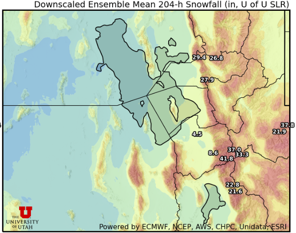
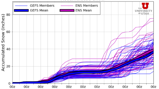
Photo: Utah Snow Ensemble model total snowfall through next Friday // UofU Dept. of Atmos. Sciences
Storms to impact Park City on Saturday, Monday/Tuesday, and continue into early April as active weather pattern dominates
PARK CITY, Utah—Miracle March isn’t over yet, as a series of winter storms are slated to arrive in Utah over the following week. The source is a large low-pressure center off the Pacific Northwest coast that has brought severe weather to the Oregon and Washington state areas.
In Utah, overnight, we had a weak disturbance that brought in some dust ahead of it with gusty southerly winds and 10 to 15-degree cooler temps for today with a chance of some flurries in the higher terrain tonight.
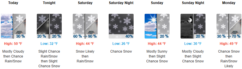
Things really begin to ramp up on Saturday morning as the first of several storms arrive, with a cold front forecast for around midday. Snow levels will start high, around 6500 feet, and accumulations will be modest with this system, bringing 4 – 10” of snow across the Wasatch. Snow showers may potentially linger into Sunday in the unstable west-northwest flow.
After a quick break Sunday night into Monday, a stronger piece of the large storm system off the coast moves into the area. This will be colder and have more moisture than the Saturday storm, with accumulations potentially in the 12-18” range for the Wasatch. The main cold front is slated to arrive Monday evening, with snow persisting into Tuesday night. There remains a chance for some thunderstorms embedded with this stronger cold front.
Eventually, by Wednesday evening, the large-scale low is forecast to break down and move eastward across the western US. This will keep Utah in an unstable, moist northwest flow pattern through Thursday evening, with additional accumulations expected from more snow shower/squall-type precipitation.
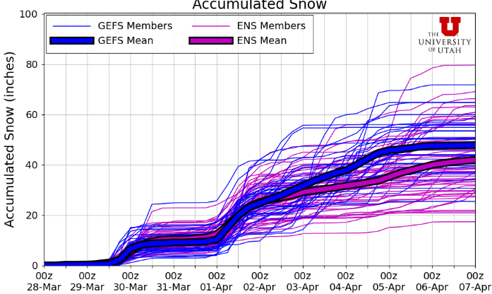
With March already being above average for snowfall and northern Utah drainages reporting near- or slightly above normal snowpack for this time of year, the active week on tap will only help increase our chances of an above-average 2024-2025 season.
By: Adam Lenkowski

1271 Lowell Avenue, C202
Park City, UT 84060
1355 E Snow Canyon Parkway, Lot 27
Ivins, UT 84738
4155 S Parkview Drive
Salt Lake City, UT 84124
4170 Vista Antigua Road
Moab, UT 84532
1104 West 10125 South
South Jordan, UT 84095
4028 E Outcrop Road
Park City, UT 84098Talk of the Town


Park City Jobs

SENIOR HOA BOOKKEEPER WANTED, Compass Management Services
4 days ago Full time

Systems Administrator, Basin Recreation
8 days ago Full time $70,645 - $88,306 yearly
Accounts Payable Lead Coordinator, Basin Recreation
8 days ago Full time $58,871 - $73,588 yearly

Logistics Specialist, PACIFICORP
9 days ago Full time $28.71 hourly
Maintenance Tech, Utah Olympic Park
9 days ago Full time $20.00 - $24.00 hourly