Weather
“Miracle March” presents 2 feet Tuesday coming to the Wasatch this week
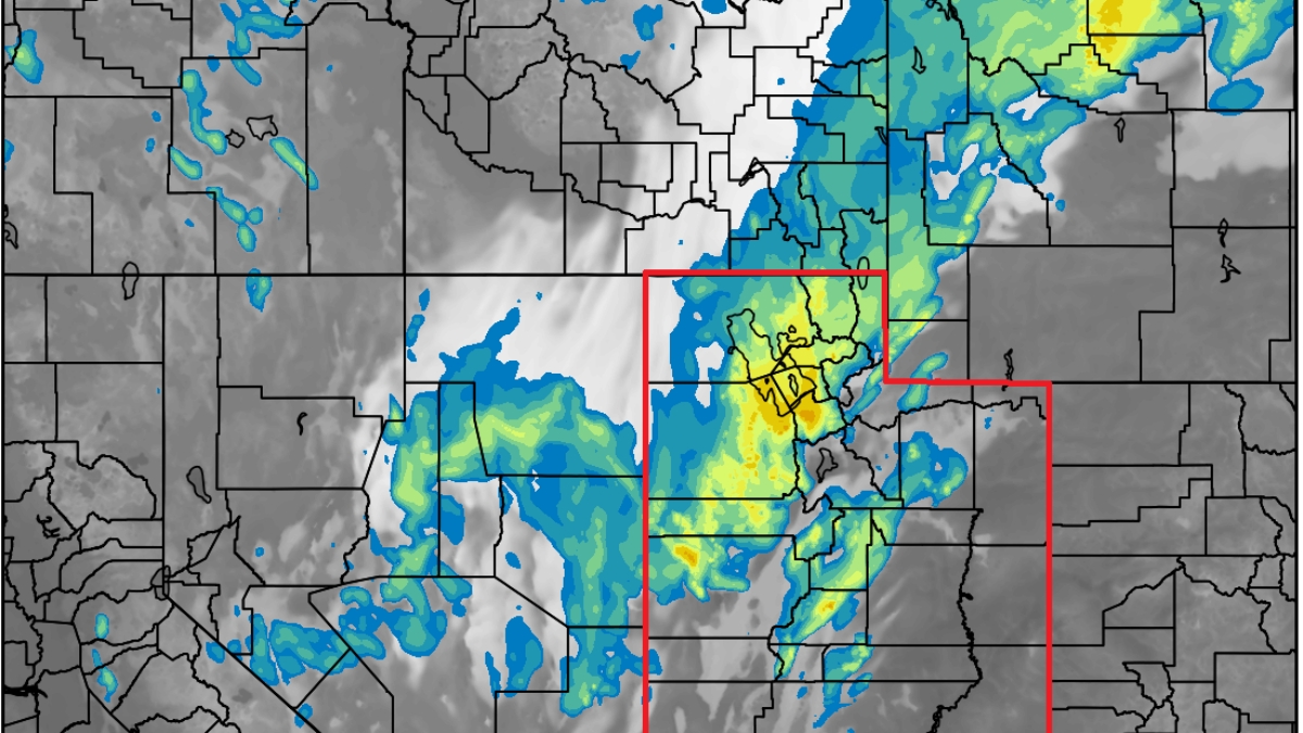
HRRR model satellite and radar image showing the strong cold front arriving overnight. Photo: UofU Dept. of Atmospheric Sciences
Strong cold front slated to arrive late tonight – active weather pattern remains in place through the weekend
PARK CITY, Utah – Strong southerly winds have been ripping since Sunday morning, preceding the strong cold front that is forecast to arrive late tonight across northern Utah. Temperatures will drop about 20 degrees for Park City by tomorrow, bringing with it 3 to 6 inches of snow in town. Salt Lake City and the town of Park City both remain under winter weather advisories through tomorrow evening.
The Wasatch mountains are set to receive anywhere from 1 – 2 feet with this storm system, with locally higher amounts in the Cottonwoods as a prolonged period of northwesterly winds sets in for most of the day on Tuesday with snow squalls forming into the evening. There remains a chance of lightning associated with this cold frontal passage, and also a chance of lake effect/enhancement.
Forecast mountain snow totals
| Location | Low-End Amount | Expected Amount | High-End Amount |
| Alta, UT | 10″ | 22″ | 41″ |
| Brighton Resort, UT | 7″ | 16″ | 30″ |
| Canyons Village, UT | 6″ | 16″ | 23″ |
| Deer Valley, UT | 5″ | 8″ | 15″ |
| Park City Mountain Resort, UT | 5″ | 12″ | 19″ |
| Snowbasin Resort, UT | 5″ | 9″ | 15″ |
| Snowbird Resort, UT | 10″ | 23″ | 44″ |
| Solitude Mountain Resort, UT | 9″ | 22″ | 35″ |
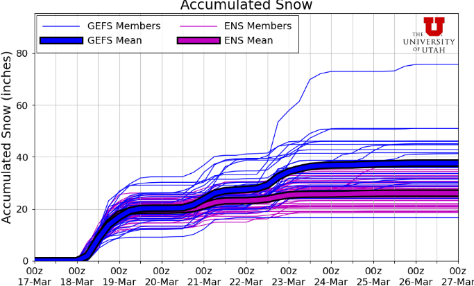
While we are just barely over halfway through March, this next storm will likely make March the snowiest month of the season for many mountain locations. So far, Alta has reported 96” of snow in March, just shy of the February amount of 109”, which is currently the snowiest month for 2024-2025. Park City reported 29” of snow with the Thursday – Saturday storm cycle last week, while Little Cottonwood received around 3 feet of snow.
Extended outlook – active pattern remains in place
Looking ahead for the rest of the week, there’s a chance for some weaker, glancing type storms on Thursday, and then again on Saturday. Much will depend on if the location of these change slightly, as Utah remains on the southern end of the moisture for both of these smaller systems. Snow totals may be more in the 4-8” range for these storms later in the week, but that could likely change.
By: Adam Lenkowski

2075 E Munsey Drive
Moab, UT 84532
1511 S Valley View Circle
Springville, UT 84663
8905 Parleys Lane
Park City, UT 84098
371 N Pinion Hills Drive
Dammeron Valley, UT 84783Talk of the Town


Park City Jobs

Ranch/Property Manager, PAlms Property Management Inc
1 day ago Full time $45,000 - $65,000 yearly

Banquet Manager, Black Rock Mountain Resort
2 days ago Full time $85,000 - $90,000 yearly
Concerts on the Slopes - Event Staff, Park City Performing Arts
5 days ago Seasonal $20.00 - $35.00 hourly
Concerts on the Slopes - Hospitality Assistant, Park City Performing Arts
5 days ago Seasonal $20.00 - $30.00 hourly
Concerts on the Slopes Venue Coordinator, Park City Performing Arts
5 days ago Seasonal $2,000 - $2,500 weekly