Top Stories
The Great Salt Lake has risen by a foot but how does that affect its dire state?
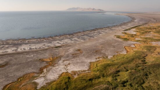
Silver Sands Beach area at Great Salt Lake State Park. Photo: TownLift | Kevin Cody.
UTAH — While Utah might be recovering from a severe statewide drought with an above-average winter, it’s been slow going for Great Salt Lake as the time to act is rapidly decreasing if we are to save the lake as we know it. As of January 18, Great Salt Lake’s average depth has risen by a foot; although a minor win in the sense that this is occurring well before the typical rise from snowmelt, the lake is still in a dire state with significant consequences on the horizon.
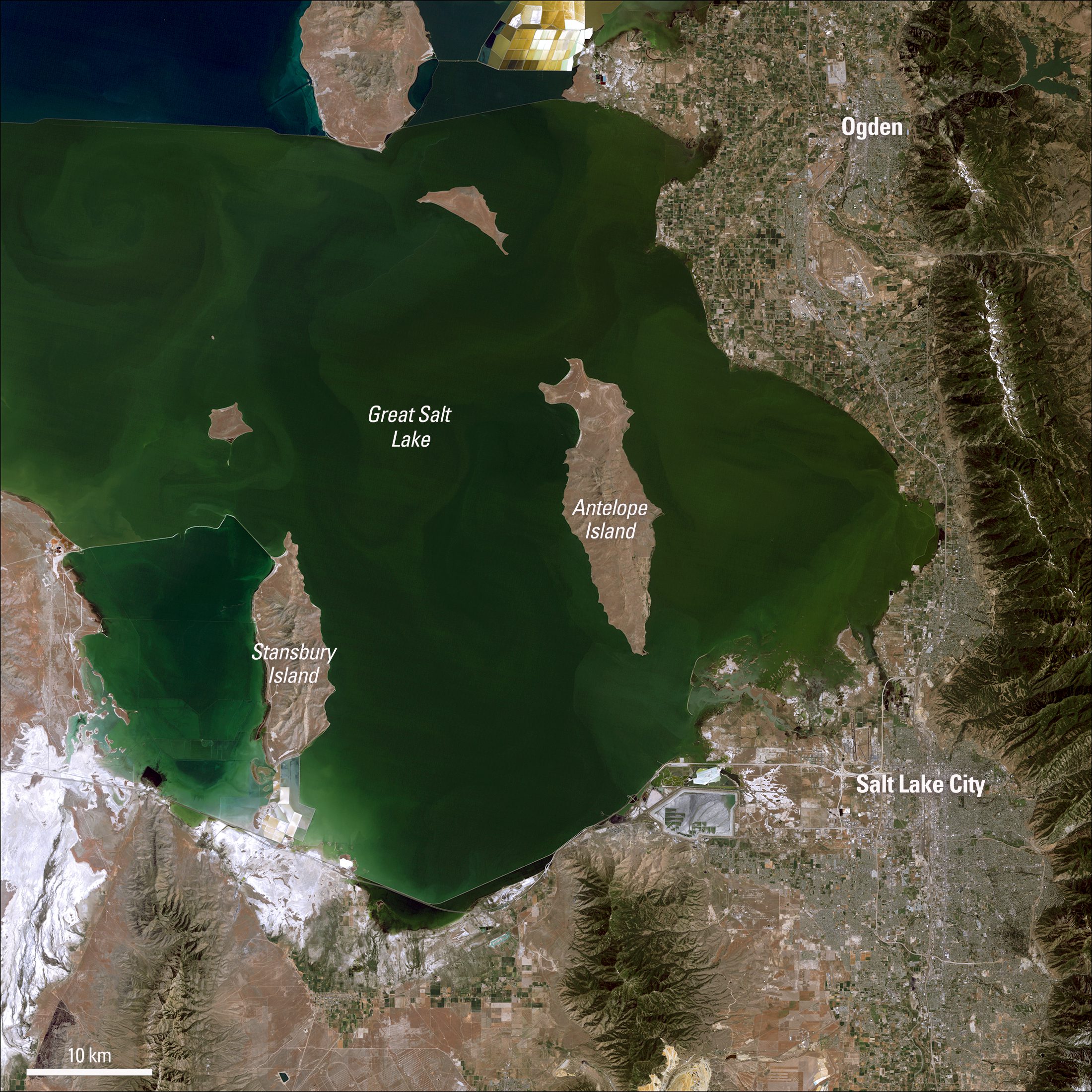
Great Salt Lake is immense as it spreads 75 miles long and 35 miles wide at its extremes. On average, the lake reaches an average depth of 14 feet, with its maximum point reaching 35 feet deep. Over a year, it is normal for water levels to vary, with evaporation and snowmelt playing prominent roles. It’s typically the highest in April or May and lowest in October or November.
“If we have an average snowpack year, the lake will rise two or two and a half feet during its high point. During the summer heat, around two and a half feet will typically be lost from evaporation. If we have an average year, the net is that the lake loses. We have to have 130 percent of snowpack just for the lake to break. This new snow year is very similar to what we had in 2017. During that year, the lake rose four and a half feet, but we lost three feet due to evaporation, creating a net gain,” said Dr. Kevin Perry, Department Chair of Atmospheric Sciences at the University of Utah
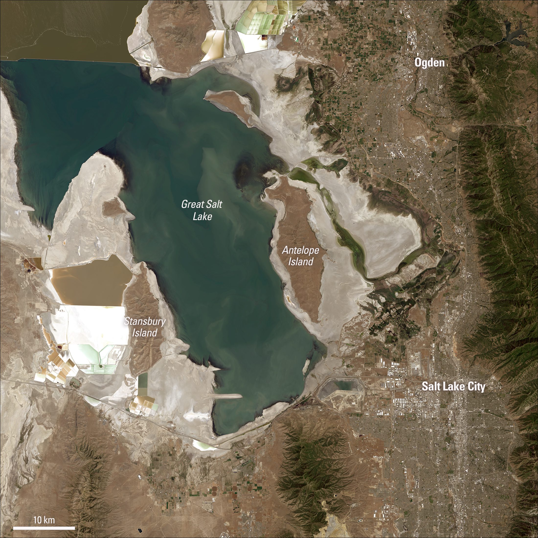
Much of the problem stems from choices made for human water usage and diverting water from its three primary sources: the Bear River, Weber River, and Jordan River. The lake has been on a negative trajectory for many years, with a new record low in November 2022. While the state legislature and public outcry have made a difference, the window for drastic change is closing as a series of tipping points continues to be crossed.
First Tipping Point: Dust Production
“About ten years ago, the lake got low enough that enough of the lake bed was exposed that I started seeing dust plumes coming off the lake. As water levels continue to go down, what’s likely to happen is that the dust storms will become more frequent and severe. Utah already has multiple air quality challenges, with the effects of inversion trapping local pollutants in the winter and wildfire smoke and ozone problems during the summer. With the addition of dust storms coming from the lake, we likely will go from having seasonal air quality problems to year-round air quality challenges,” Perry said.
Dust storms can be dangerous for various reasons, such as a reduction in visibility and the potential for dust particles to reach high enough concentrations to make the air unhealthy, according to EPA standards. Although air quality problems from breathing in particulates are a health risk regardless of the source, the lake also contains high levels of arsenic and other metals that could be put into the air.
“It’s what we call a contaminant, a potential concern which means that we know there are high concentrations in the soil. We don’t know what the concentration of arsenic in the dust will be once it reaches the surrounding community, and we don’t know how frequently that is transported. We don’t know whether the arsenic is in a form that can be absorbed into the body or whether it’s likely to be locked up in minerals that don’t interact with the body. Until we answer those three questions, we can’t say whether arsenic poses an actual risk to the surrounding people. But right now, it’s something of concern that we need to do more studies on,” Perry said.
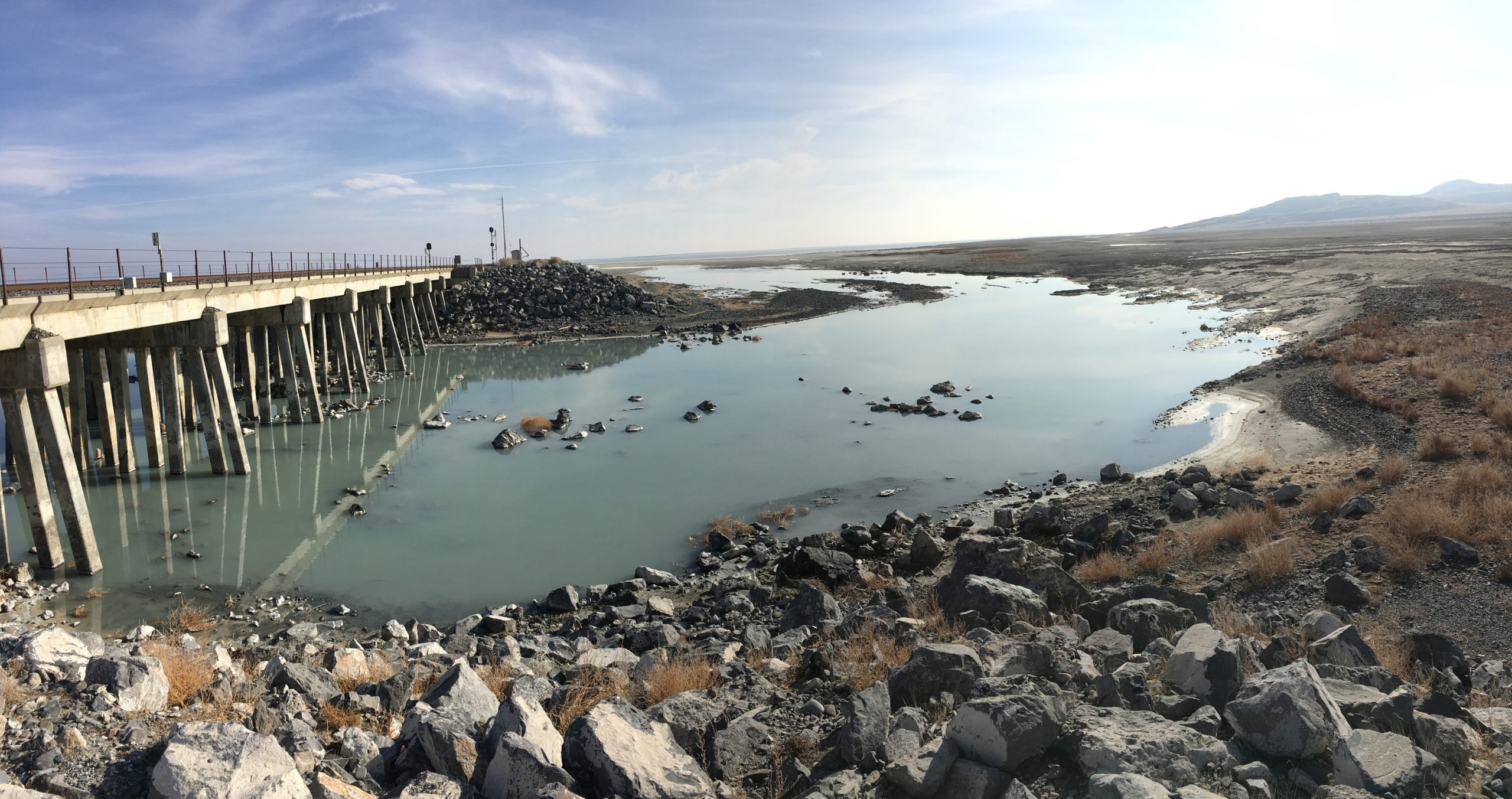
Recreation at the lake was once a significant pull of visitors to the state. The original Saltair, from 1893 till it burned down in 1925, operated as an amusement park that rivaled New York’s Coney Island. The peak of attraction occurred in the 1920s when nearly half a million people visited the lake each year. There was even a paddle steamship that provided sightseers trips across the lake. That history is hard to imagine in its current state, with nearly all the dock areas unusable and sailboats sitting on trailers rather than in the water.
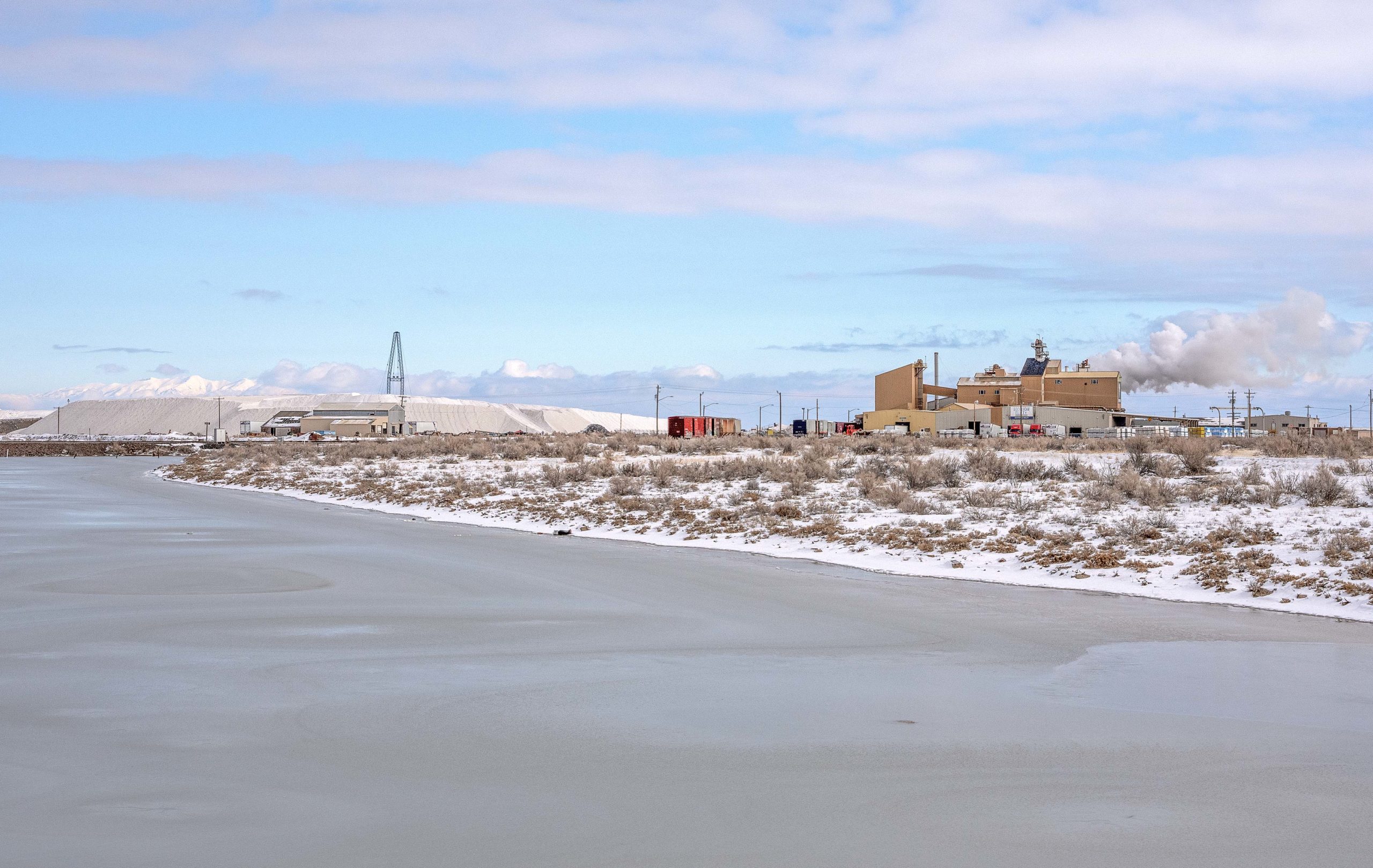
“The recreation tipping point was when they had to pull all the boats off the water because the marinas were dry. Before that, millions of dollars were spent dredging to try and keep the marinas open, which eventually became pointless. The recreation opportunities were lost, and now the lake is getting so low that the companies that extract the water for minerals, like, US Magnesium, Compass Minerals, Morton Salts, and Cargill Salts, are having trouble getting water to their plants,” Perry said.
Mining companies have spent millions of dollars over the years dredging areas so that they can continue to operate. These operations are a significant source of supply of magnesium, sulfate of potash, and brine shrimp. Minerals such as sodium chloride, common salt, potassium sulfate, magnesium chloride, magnesium metal, and lithium are extracted from the lake. Even though the extracted sodium chloride is not pure enough to be used for human consumption, it is heavily used around the state in the battle to melt ice on roadways. Park City Municipal, for example, uses salt from the Great Salt Lake during the winter.
“US Magnesium’s canal doesn’t even reach the water right now, so they don’t have access to water. They put in a petition to dredge the canal deeper and further to get access to the water, and that was denied. So they’re scrambling, trying to figure out what they’re going to do. The extraction industry is more than a billion dollars a year, and we’re getting close to the tipping point where that goes away,” Perry said.
Third and Final Tipping Point: The Rise in Salinity Collapses the Ecosystem
Many of Great Salt Lake’s inhabitants depend on brine shrimp and brine fly larvae to survive. These two food sources act as the primary source at the base of the food chain, on which everything above it depends on it. As the lake shrinks, there is less water to reduce the salinity level to a percentage where they can thrive and reproduce.
“It’s one thing to have decreasing lake levels, but the 10 million migratory birds, the brine shrimp, are all depending on a certain salinity to survive and thrive. The Salinity Advisory Committee identified a range of salinity, a percent of salinity that is acceptable or healthy to all the brine shrimp and brine flies, and other organisms in the lake. The ideal range is from 12 to 16%. Since the end of last year, we were like hovering around 19%, So we are well above the salinity range acceptable for these organisms,” said Laura Vernon, Great Salt Lake Planner for the Utah Department of Natural Resources.
Millions of birds use the lake as a stopping point on their migrations each year, with many choosing to stay at the Great Salt Lake year-round. The lake supports 80 percent of the state’s wetlands. Birds like the American white pelican and California gull use the isolated islands as rookeries. Up to 20,000 breeding adult pelicans used Gunnison Island. Over 2.5 million eared grebes visit the lake; at its peak, over half the North American population is at the Great Salt Lake. Around a third of the world’s phalaropes species use the lake as a staging ground for the migration south.
“We’ve started to see that brine flies were absent this past year. That could be because the lake levels dropped so much that the microbialites, like the coral reef of the lake where these brine flies thrive, are all exposed, so there’s no habitat for them,” Vernon said.
“The last time I was out there was in October, and usually at that time, there would be millions and millions of brine flies, but there were absolutely none. It’s the first time in my life. I’ve been out there next to the water without millions of brine flies. The birds that would normally be feasting on those were not there because there was nothing to eat; instead, they were out in the water trying to pick up the brine shrimp, which is a much more difficult task for them. If the brine shrimp and the brine flies disappear, then the millions of birds that visit this lake ecosystem on their migratory path will find the cupboards empty, leading to starvation and death. We’re really close to that, and once we hit that point, then the Great Salt Lake will essentially become like the dead sea in that it’s not a vibrant ecosystem anymore,” Perry said.
Is there any hope
One stopgap measure that can be implemented quickly centers around the Union Pacific Railroad causeway that separates the lake’s north arm with its high salinity levels from the south arm in which life is still present. The causeway has a breach at its westernmost point where the two arms mix. If the breach were closed off, it would stop saltier north-arm water from moving into the south arm. Closing off the breach would also keep the freshwater inflows from the Weber, Bear, and Jordan Rivers only flowing in the south arm. The hope is that this would cause a rapid rise in elevation and decrease salinity. In June, the berm was modified with four feet of fill, but the flow was not completely cut off. It’s possible that the reduced flow could have contributed to the foot rise in elevation.
“It’s a wild management tool I never thought we would have at our fingertips. If you were to tell us 10 or 15 years ago when closing the causeway breach was first contemplated that we would be in the situation of having to use the breach in this way. I don’t know that I would have believed you, but today, it is a reality and a great tool we have,” Vernon said.
While closing the causeway breach and having above-average winters with high snowpacks, such as this year, helping to reverse some of the tipping points helps, it doesn’t change the problem of water usage causing less flow to enter the lake, but it does allow for more time to act though not unlimited amounts.
“If we have solutions that take ten years, that’s probably going to be too late because we’re already about to hit this last tipping point, and the lake will be dead. Until recently, I was super pessimistic because I didn’t think the lake would be resilient and be able to recover if the water came back. I’ve since learned that there are pockets of groundwater infiltration that artificially lower the salinity. So there will be pockets of brine shrimp and brine flies that survive, so if we bring water back to the lake, they can help restore it. So it’s not like the lake will be dead forever, but the millions of birds that died in the process will have a hard time recovering. The lake is more resilient than we think, but that’s not the point. The point is that we should avoid the tipping point at all costs,” Perry said.

By: Kevin Cody

950 S Aspen Circle
Woodland Hills, UT 84653
2410 W Entrada Trail, Unit #4
St. George, UT 84770
4739 W Snowflake Drive
Highland, UT 84003
1011 E Mill Road
Heber City, UT 84032Talk of the Town


Park City Jobs
Venue & Event Coordinator (Kimball Arts Festival VIP Lounge), Kimball Art Center
6 days ago Seasonal $20.00 - $22.50 hourly

Summer Garden Educator and Counselor, Summit Community Gardens and EATS
7 days ago Seasonal $19.00 - $20.00 hourly

Job Fair May 26 2026, Grand Hyatt Deer Valley
8 days ago Full time
Sales Advisor, O.C. Tanner
8 days ago Full time $30.00 hourly
Reservations Coordinator, National Ability Center
11 days ago Full time $22.00 hourly