Weather
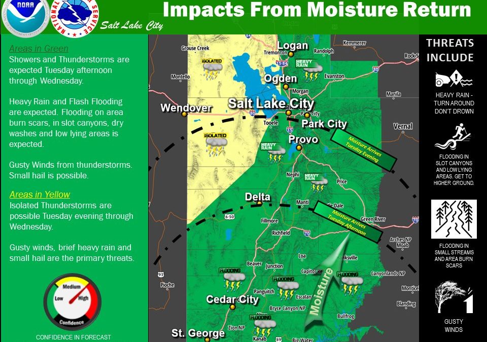
Rain expected across all of Utah

A look at the next two days. Photo: National Weather Service
PARK CITY, Utah — Smoke from western wildfires will continue to impact northern Utah through the day on Tuesday, August 31. It will stay around at least through Wednesday.
1/2 First up for today…your smoke outlook. Near surface smoke concentrations will remain most elevated near the Utah/Idaho border. #utwx pic.twitter.com/kKC2xYfO43
— NWS Salt Lake City (@NWSSaltLakeCity) August 31, 2021
Through Wednesday night, there will be a threat for flash flooding across specifically southwest and south-central Utah.
On Wednesday, the threat of flash flooding will spread north and east. While most of the risk is in the southern portion of the state, the new burn scar from the Parley’s Canyon Fire is concerning.
The biggest threat for flash flooding is burn scars, slot canyons, normally dry washes, slick rock areas, and near steep terrain.
Officials with the U.S. Forest Service have said the burn scar will create a flash flood threat for potential the next five years near I-80.
The threat of heavy rainfall and the potential for flash flooding with continue to spread north and east tonight into Wednesday. Additional flash flood watches are in effect for portions of central and eastern Utah starting at midnight tonight. #utwx pic.twitter.com/4nIysDDHtO
— NWS Salt Lake City (@NWSSaltLakeCity) August 31, 2021
Below is the forecast for Park City for the rest of the workweek courtesy of the National Weather Service:


