Weather
Pack Creek Fire threatens Moab
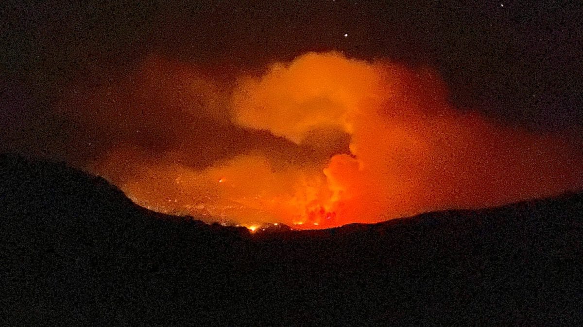
The glow from Sothern Utah's Pack Creek Fire, looking into Moab on June 10. Photo: Bureau of Land Management – Utah
MOAB, Utah. — As of today, June 13, the Pack Creek Fire, 10 miles southeast of Moab, is 6% contained at a size of over 5,400 acres and it has reached an elevation over 11,000 feet in Utah’s second-highest mountain range, the La Sal Mountains. The blaze was human-caused through an unattended and abandoned campfire. The affected area is part of the Manti-La Sal National Forest.
Three structures so far are known to have been lost. As of June 13, evacuations have been lifted for Lower Pack Creek and evacuation orders are still in place for homes past the U.S. Forest Service boundary, according to Utah Fire info.
This extraordinary view from the @CanyonlandsNPS Island in the Sky webcam shows the explosive growth of the #PackCreekFire today. Pyrocumulus clouds (also known as Flammagenitus clouds) can be seen at the top of the smoke plume, often an indicator of extreme fire intensity. #UTwx pic.twitter.com/dw8q9JPTFl
— NWS Grand Junction (@NWSGJT) June 10, 2021
Per the U.S. Drought Monitor, all of Grand County, Utah is experiencing either an extreme or exceptional drought.
On Thursday, FEMA authorized the use of funds to fight the fire. “The authorization makes FEMA funding available to pay 75 percent of the state’s eligible firefighting costs under an approved grant for managing, mitigating, and controlling designated fires. These grants do not provide assistance to individual home or business owners and do not cover other infrastructure damage caused by the fire,” FEMA said in a press release.
The air quality index for Moab is listed as moderate and 2 times above the World Health Organization’s exposure recommendation.
By: Parker Malatesta

6110 E Blue Wing Loop
Kamas, UT 84036
3764 Prickly Pear Circle, Unit 5-A6
Moab, UT 84532
1042 W Shoreline Drive
Layton, UT 84041
1545 N Red Castle Circle
Heber City, UT 84032
2304 N Cohonina Trail
St. George, UT 84770
760 E Edgehill Rd
Salt Lake City, UT 84103Talk of the Town


Park City Jobs

Digital Marketing Associate, Park City Community Foundation
1 day ago Contractor $24.00 - $27.00 hourly

Equestrian Stall Cleaner/Feed - EVENINGS, Part-time, SkyRidge
2 days ago Part time $22.00 hourly
Barista/ Cashier, chomp donuts
3 days ago Full time $17.00 - $25.00 hourly
Pastry chef/ Donut Chef, chomp donuts
3 days ago Full time $55,000 - $75,000 yearly
Donut chef/ maker, chomp donuts
3 days ago Full time $17.00 - $24.00 hourly