Environment
Warm winter, low snowpack shape Utah’s summer 2026 water outlook
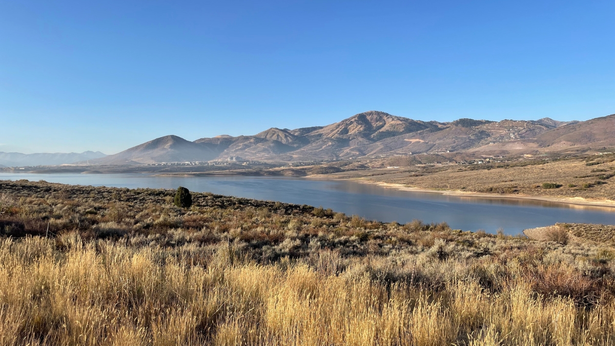
Jordanelle and views of Deer Valley on Oct. 11, 2024. Photo: TownLift // Marina Knight
PARK CITY, Utah — Utah is heading into spring with a concerning water outlook after a historically warm winter and unusually low snowpack, according to the National Weather Service’s March 2026 Water Outlook Briefing.
While total precipitation since October sits just slightly below normal in many areas, forecasters say that number is misleading. Much of this winter’s moisture fell as rain instead of snow at lower and mid elevations, limiting the potential for spring runoff, which is a typical indicator of how much water will stored for the dry summer months.
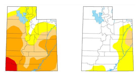
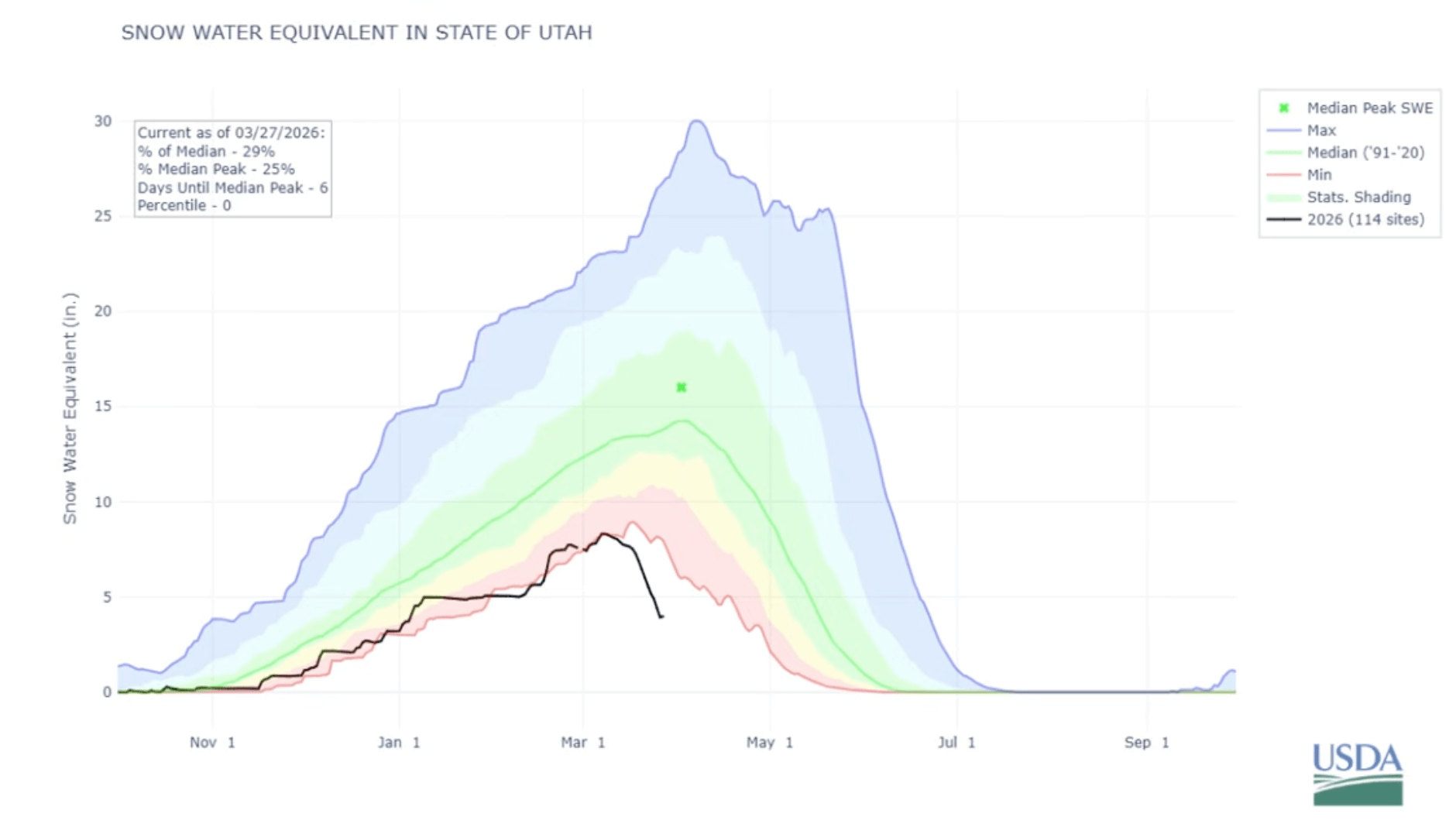
Recent, late-season storms in Utah provide minor temporary relief to ski areas but are insufficient to recover the historically low snowpack, which is at roughly 19% to 20% of the normal peak.
“This year has been characterized by a warm snow drought,” meteorologists said, noting that storms were both infrequent and often too warm to produce meaningful snowfall.
Utah’s snow water equivalent — a key measure of how much water is stored in the snowpack — peaked at just 8.5 inches this year, roughly half of the typical 15 inches and one of the lowest totals recorded in more than four decades. Snowpack has already begun melting weeks earlier than normal, when it would typically still be accumulating into early April.
In many parts of central and southern Utah, snowpack has already disappeared entirely, with only higher elevations in northern Utah holding onto limited snow.
That early melt is also driving unusually high soil moisture levels statewide, as water is absorbed into the ground rather than gradually feeding streams and reservoirs. While reservoirs currently sit slightly above median levels, officials warn they may peak earlier than usual, potentially leading to lower supplies later in the summer.
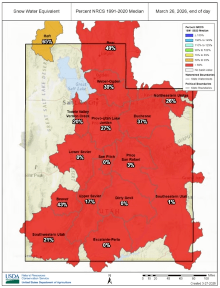
Water supply forecasts reflect those concerns. Most river basins across Utah are expected to produce well below normal runoff, with many projected at less than 70% of average and some dropping below 30%.
The diminished snowpack also means a low risk of spring flooding, with less than a 10% chance of reaching flood stage on monitored rivers.
Drought conditions remain widespread. About 98% of Utah is currently experiencing at least moderate drought, with extreme drought expanding in parts of the state.

Looking ahead, short-term forecasts offer a modest glimmer of hope. Early April could bring a wetter pattern and near-normal temperatures, but longer-term outlooks favor warmer and drier conditions through the spring.
Water managers say the combination of early snowmelt, low runoff, and persistent drought underscores the importance of water conservation as Utah heads into the summer months.
By: Heather Bergeson

965 Goshen Canyon Road
Mona, UT 84645
24 South 600 East
Salt Lake City, UT 84102
10584 Basin Canyon Road
Park City, UT 84098
19 East 100 North
Spring City, UT 84662Talk of the Town


Park City Jobs

Assistant Manager, LOMA
8 days ago Full time $35.00 hourly
Property Inspector, Park City Rental Properties
8 days ago Full time $23.00 - $25.00 hourly
Owner Relations Manager, Park City Rental Properties
8 days ago Full time
Operations Manager, Park City Rental Properties
8 days ago Full time

Hiring Barista Assistants and Baristas, Silver King Coffee
11 days ago Part time $17.00 - $30.00 hourly