Environment
Low snowpack, warm winter could raise wildfire risk in Utah
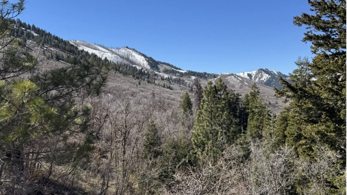
Limited snowpack, as seen from Parley’s Summit looking west into Parley’s Canyon. Normally, this area would be covered with several feet of snow this time of year. The snowfield on the left side of the photo is the Parleys Canyon Fire burn area from 2021. Photo: Brad Washa
PARK CITY, Utah — Utah’s record-low snowpack and unusually warm winter could contribute to an earlier and potentially more intense wildfire season this year, according to a Utah State University Extension wildfire specialist.
Bradley Washa, an assistant professor of wildland fire science with USU Extension, said conditions across the state at the end of March are raising concern, even though it remains too early to predict exactly how the fire season will unfold.
“As we approach the end of March, snowpack is at record-low levels across the state,” Washa said. He added that Utah also experienced its warmest winter on record, with much of the season’s precipitation falling as rain rather than snow.
The lack of snow is especially noticeable at mid-level elevations, Washa said, where there is only a light dusting when there would typically be several feet of snow.
The conditions could affect different parts of the state in different ways.
On lower-elevation rangelands, Washa said limited snow meant there was less compaction of last year’s plant growth. At the same time, significant rain in October and through the winter increased soil moisture, which could support the growth of fine fuels such as grasses if moisture persists through the growing season.
One concern is cheatgrass, an invasive species that dries out early and ignites easily, potentially increasing fire risk as summer approaches.
In areas where grasslands transition into brush and pinyon-juniper woodlands, Washa said fire season could begin earlier than usual, particularly in higher elevations of southern Utah.
At higher elevations, the concern shifts to forests and heavier fuels. Washa said downed logs and other forest vegetation could dry out sooner if snow melts earlier than normal, potentially lengthening the fire season and increasing fire intensity.
“Instead of the fire season becoming active in July, it could begin in June,” Washa said.
The Great Basin Coordination Center’s Predictive Services Fire Potential Outlook has already identified above-normal significant wildland fire potential in parts of southern Utah heading into June, according to Washa.
Still, Washa said several variables will shape how the season develops.
He noted that Utah has seen years with strong snowpack that still produced active fire seasons after record-setting heat in May and June caused rapid snowmelt, followed by thunderstorms that sparked fires across the state.
In other years, dry winters pointed to a potentially severe season, only for late-spring and early-summer rainstorms to moderate fire activity.
Summer monsoons also can shift fire behavior, Washa said. While lightning can ignite fires, widespread rain and higher humidity can slow fire growth or help bring the season to an end. A weaker monsoon, by contrast, can allow fire activity to continue later into summer and into the fall, especially in southern Utah.
With warm temperatures and dry conditions already emerging, Washa said now is the time for residents to prepare their properties.
Washa also said wildfire prevention remains critical this spring, especially as Utah has already seen human-caused fires before widespread green-up.
“When visiting, working, or living in the wildland, we all have a shared responsibility to prevent wildfires,” Washa said.
For prevention information, Washa directed residents to SmokeyBear.com.
By: Rebecca Brenner

137 W Bridlewood Lane
Midway, UT 84049
2154 S Rio Verde
Moab, UT 84532
2400 E Walker Lane
Holladay, UT 84117
2475 W White Pine Lane
Park City, UT 84060Talk of the Town


Park City Jobs
Recreation Services, Associate Manager, Basin Recreation
1 day ago Full time $84,774 - $105,967 yearly
Kimball Arts Festival Entry Gates Coordinator/Ticket Seller, Kimball Art Center
1 day ago Seasonal $20.00 - $25.00 hourly

Bilingual Mentoring Support Coordinator - Summit/Wasatch Counties, Big Brothers Big Sisters of Utah
1 day ago Full time $21.00 - $22.00 hourly
Associate HOA Manager - Full Time, Sea to Ski Property Management
3 days ago Full time

Food & Beverage Operations Manager, Hotel Thaynes
6 days ago Full time $70,000 - $80,000 yearly