Weather
Winter returns with up to 3 feet of snow forecast for the Wasatch by Thursday
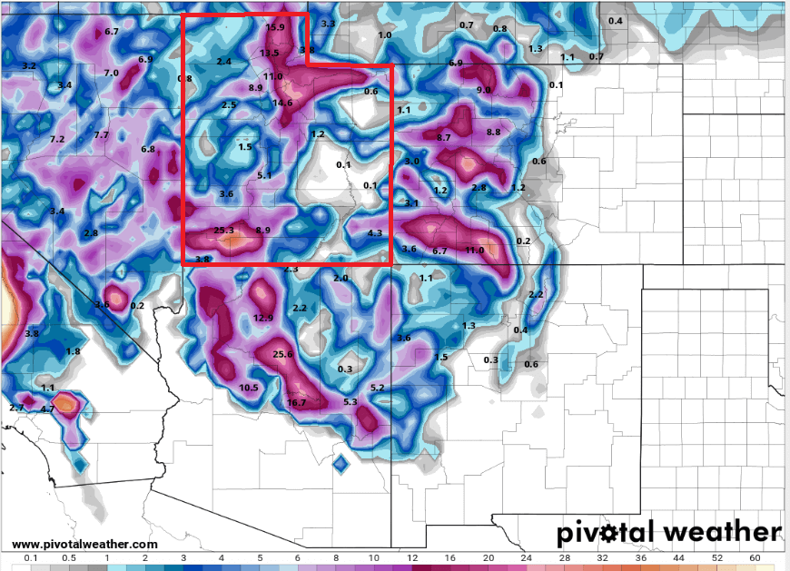
Photo: GFS model total snowfall (10:1 ratio) through Thursday // PivotalWeather.com
Winter storm warning issued for the town of Park City with snow accumulations of over 12 inches expected
PARK CITY, Utah – Utah’s mountains and low-elevation valleys are about to get a plastering of fresh snow this week with two well-defined storms on track. The first begins overnight tonight into Tuesday, and the second storm Tuesday night into Wednesday, with an active pattern continuing in the long-range outlook as well.
Very strong south-southwest winds and warm temperatures will continue today ahead of a powerful cold front moving in overnight, with some light showers expected in the higher terrain beginning late this afternoon. Heavy snow will begin in the early morning hours and lower in intensity by Tuesday afternoon. Snow levels will also drop from near 7500 feet to 4500 feet during this period, allowing the snowline to potentially reach lower-elevation valley benches by mid-morning.
Forecast Snow Totals: Tonight – Thursday
- Cottonwood Canyons: 24 – 38″
- PC Base/Town: 10 – 18″
- Deer Valley/PCMR: 18 – 26″
- N. Wasatch (Powder/Snowbasin): 18 – 28”
Winds shift briefly to more westerly during this first storm but return to southwesterly ahead of the next approaching cold front, which is forecast to push through northern Utah on Wednesday morning. Snow levels will plummet even further, enabling snow in all lower elevation valleys with this next system. Winds are forecast to finally shift more west-northwesterly with the Wednesday storm, which is even colder and will provide another one to two feet of snow in the mountains. This is where favored areas such as the Cottonwoods could pick up additional accumulations, as snow showers will likely persist into Thursday morning before tapering off.

Skiers and riders in Utah got a much-needed taste of winter last week as most areas in the Central Wasatch picked up about 12 inches of snow. This came after an almost month-long snow drought from early January through February.
The National Weather Service has issued a winter storm warning for Park City and numerous mountain locations in northern and southern Utah. An avalanche watch has also been issued by the Utah Avalanche Center.
Extended Outlook
There is some uncertainty between the forecast models regarding a third storm on Friday that will potentially impact northern Utah, but some guidance is pushing the storm track further south which would only affect southern Utah. The good news is, even after Friday the long-range trend remains active, with most models suggesting another low-pressure center forming off the west coast early next week.

By: Adam Lenkowski

965 Goshen Canyon Road
Mona, UT 84645
10584 Basin Canyon Road
Park City, UT 84098
19 East 100 North
Spring City, UT 84662
24 South 600 East
Salt Lake City, UT 84102Talk of the Town


Park City Jobs

Assistant Manager, LOMA
7 days ago Full time $35.00 hourly
Property Inspector, Park City Rental Properties
8 days ago Full time $23.00 - $25.00 hourly
Owner Relations Manager, Park City Rental Properties
8 days ago Full time
Operations Manager, Park City Rental Properties
8 days ago Full time

Hiring Barista Assistants and Baristas, Silver King Coffee
10 days ago Part time $17.00 - $30.00 hourly