Weather
Snow drought continues in Utah with little relief in sight through end of January
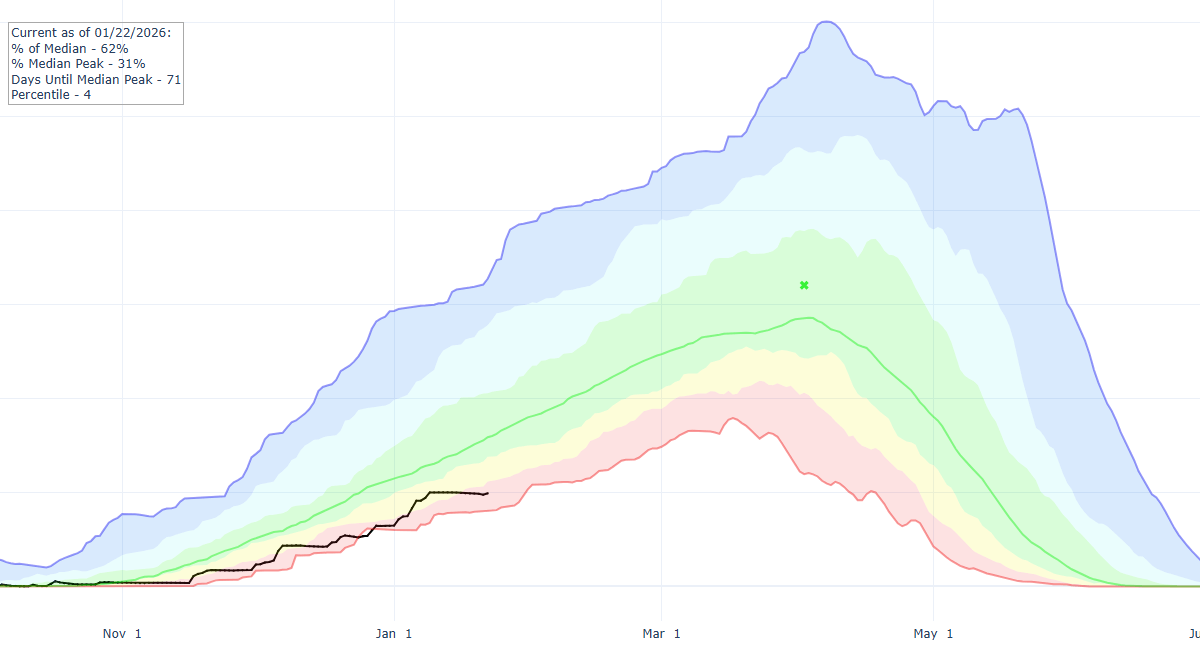
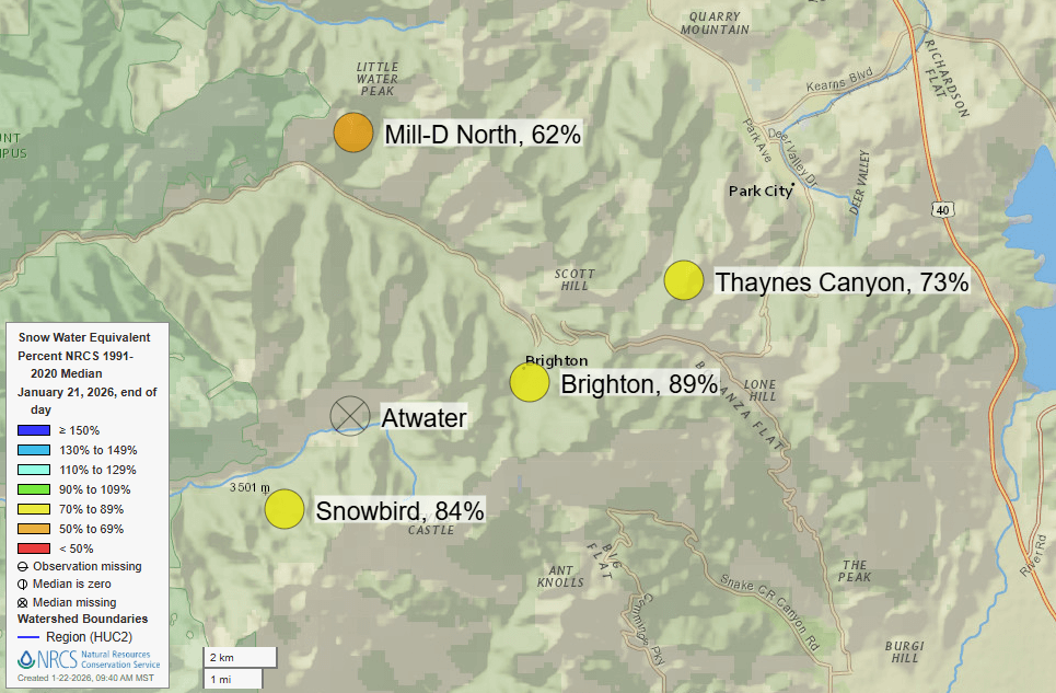
Photo: Statewide snowpack in Utah for 2025-2026 (black line) is at just 62% of normal according to the 1991-2020 median // USDA NRCS-Snow Survey
Utah’s snowpack remains well below average, with extended range outlooks indicating above normal temperatures and below average precipitation through at least the end of January while south eastern states prepare for severe winter weather
PARK CITY, Utah – As we quickly approach the end of January, Utah’s snowpack statewide sits at just 62 percent of normal compared to the most recent 30-year climatological median (1991-2020), based on data from the USDA – SNOTEL snowpack monitoring network.
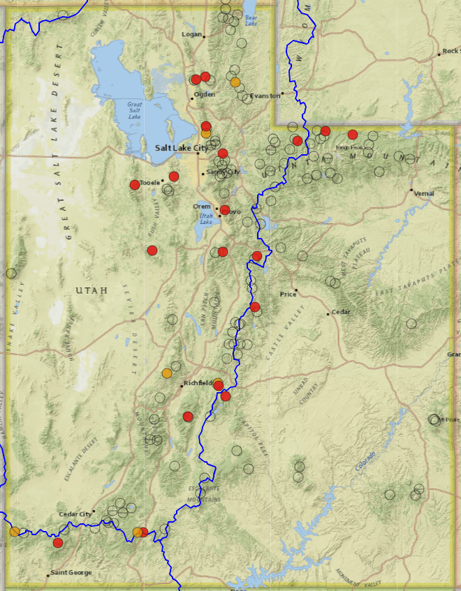
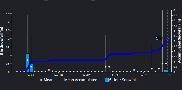
In fact, 19 of Utah’s 139 monitoring stations are reporting the lowest snowpack on record as of January 22, 2026. It’s now been 14-days since the last snow fell in the Wasatch Mountains at the tail end of a multi-day storm cycle that ended on January 9.
Unfortunately, there is little in the way of any significant snowfall in the long-range forecast to ease the snow drought conditions here in Utah.
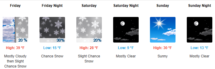
We will see a slight pattern shift Friday as a closed low-pressure system off the southern coast of California slides eastward simultaneously with a cold front approaching from the north. An increase in cloud cover along with a trace to an inch of snowfall is expected in Northern Utah, with the biggest impact being much colder temperatures moving in overnight as the cold front passes though.
Looking past Saturday, high-pressure is expected to build back into Utah as these two systems merge downstream of us and progress eastward, wreaking havoc across the South-Central U.S. in a well-advertised heavy snowfall and icing event.
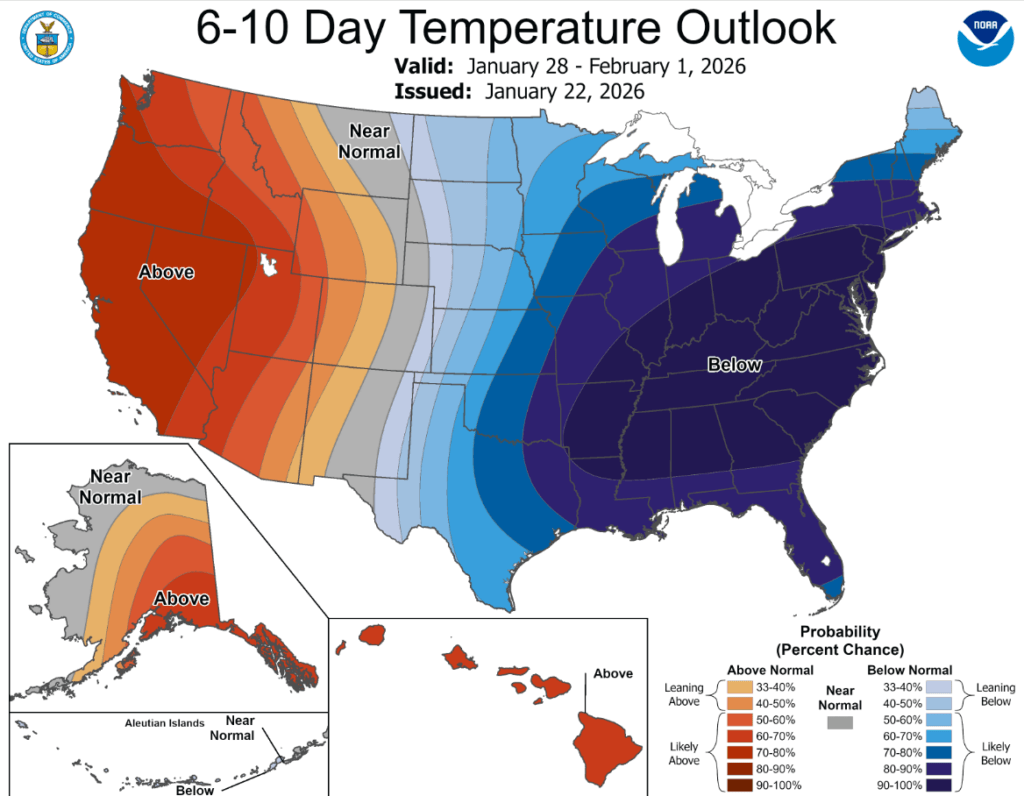
Utah looks to remain mostly dry through at least the end of next week in the long-range weather models. Extended range outlooks from the Climate Prediction Center indicate warmer than normal temperatures, and lower than average precipitation throughout the end of January.
It’s been a rollercoaster ride of weather extremes starting last fall here in Utah, with record precipitation totals in October, followed by record-high temperatures in November and December. January 2026 started off with a bang, as an impressive storm cycle began on New Year’s Day and lasted through January 9th that dropped upwards of five feet of snow in the upper Cottonwood Canyons, resurrecting the Utah ski season.
The only mountainous regions with a somewhat near-normal snowpack in Utah right now are high elevation, northern areas, primarily in the upper Cottonwood Canyons and parts of the Uinta Range. Low-elevation stations below approximately 8,000 feet are really suffering. This is mostly due to the multitude of warm, high-snowline storms we have had this season, including one such event on Christmas Eve where a large portion of the mountains in Utah received rain up to around 10,000 ft.
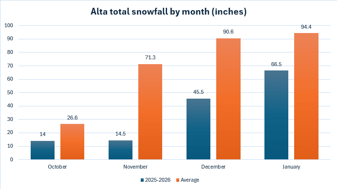
The Alta Ski Area website is reporting just 140.5” so far for October – January, or just 49.7% of normal (1980 – present); although, we still have 9 days left in January so that number may get a little better, but not by much as little snowfall is expected through the end of the month.
These numbers can be a little deceiving when compared to SNOTEL monitoring stations however, as the SNOTEL sites report in snow water equivalent (SWE), or the amount of liquid water the snowpack contains, as opposed to just snow depth measured in inches regardless of how much water it contains. Many of the storms we have received this season were warm, high density snowfall events, which would further skew the difference between these different measurements.
In addition to dismal snow conditions, The Salt Lake Valley endured a weeklong degraded air quality event last week, with 5-days in a row of “unhealthy for sensitive groups” levels of fine particulate matter, according to UDEQ-AQD monitoring stations throughout Salt Lake County from January 12–16.
Luckily, the center of the strong high-pressure region shifted further west this week, with Utah located mostly in a transition zone with some weak disturbances brushing by. This allowed for more mixing of the air in the valley and helped to keep air quality levels only in the moderate range for most of this week.
By: Adam Lenkowski

325 White Pine Canyon Road
Park City, UT 84060
3267 W Deer Hollow Road, Unit 2305
Park City, UT 84060
438 Castle Valley Drive
Castle Valley, UT 84532
80 West 300 North
Salt Lake City, UT 84103
2349 S Lava Vista Drive, Lot 32
Santa Clara, UT 84765Talk of the Town


Park City Jobs

Computer / Website Assistant, Summit Support
1 day ago Part time $20.00 - $30.00 hourly

Garden Steward and Educator, Summit Community Gardens and EATS
1 day ago Seasonal
PROGRAM AND EVENT COORDINATOR, PC READS
2 days ago Part time $25.00 hourly
Development Manager, Blue Sky Utah
2 days ago Part time $28.00 - $32.00 hourly
Executive Assistant / Property Manager Administrator, Model HOA
2 days ago Full time $30.00 hourly