Snow
2025’s final flakes: Powder alert brings mixed signals to the Wasatch for end of season
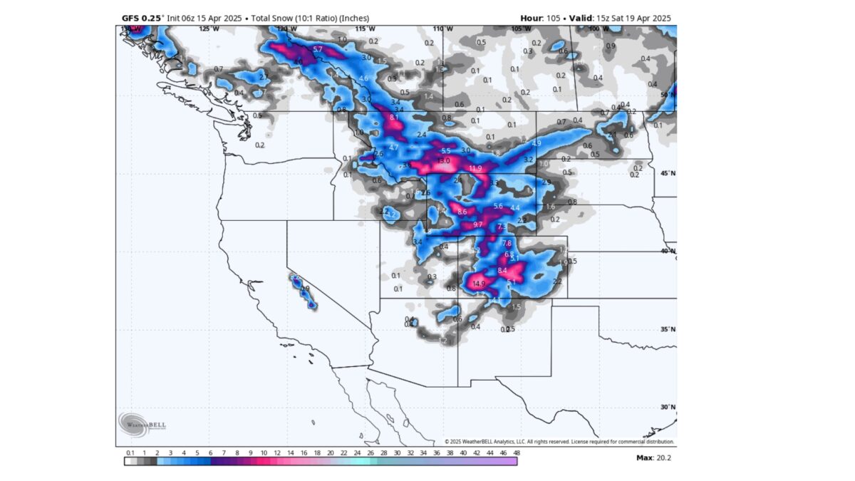
We'll have to wait for Thursday and see if Mother Nature intends to give Utah another dose of spring snow. Photo: WeatherBELL Analytics.
UTAH —The final Powder Alert of the season is going out with a flurry—literally and figuratively. A storm system rolling in from Wednesday night through Saturday brings fresh snowfall to the Rockies, covering Montana, Utah, and Colorado. While some areas are lining up for deep powder days, Utah’s outlook remains uncertain, with models wavering between a sleeper storm and a bit of a bust.
Snow is forecast to develop across Utah on Thursday, but confidence in totals is murky. The short-term North American Mesoscale Model (NAM) model is bullish, painting a picture of 12–15 inches for Alta and the central Wasatch. However, broader models suggest a more muted ending, with 3–6 inch totals and a storm track trending south of the primary ridgelines.
Alta: 5–12 inches
Brighton/Solitude/Snowbird: Likely in the same 4–10 inch range, depending on elevation and storm track
Park City: Likely on the lower end, around 2–6 inches
If the NAM wins out, Thursday afternoon into Friday morning could serve up the kind of surprise powder day that Utah is famous for.
Utah had a feast or famine season, with early-season snow giving way to dry spells, only to rebound with well-timed March storms. As of Powderchasers‘s final alert, the season ends just slightly below average in many zones, but not without its highlights—especially for the Wasatch backcountry crowd, who found quality turns well into April.
Montana is set to close the season strong, with Red Lodge Mountain (reopening April 18) possibly pulling in 20″ by Saturday morning. Big Sky remains a wildcard, with model solutions ranging from 5 to 14 inches.
Colorado, on the other hand, is the zone to watch this weekend. While model uncertainty remains high, areas like Steamboat, the Front Range (including Winter Park and Loveland), and the San Juans (Purgatory, Telluride) all have potential for double-digit dumps. Whether the northern or southern mountains win out depends on which model you believe—the American GFS favors a southerly storm path, while the Euro keeps the goods up north.
For Utah, Thursday is the day to watch. If the NAM verifies, the Wasatch could serve up one last deep day—possibly the final hurrah before the lifts stop spinning. Snow quality will be dependent on overnight temps.
By: TownLift

325 White Pine Canyon Road
Park City, UT 84060
80 West 300 North
Salt Lake City, UT 84103
438 Castle Valley Drive
Castle Valley, UT 84532
2349 S Lava Vista Drive, Lot 32
Santa Clara, UT 84765
1511 S Valley View Circle
Springville, UT 84663
3267 W Deer Hollow Road, Unit 2305
Park City, UT 84060Talk of the Town


Park City Jobs

Hiring Barista Assistants and Baristas, Silver King Coffee
8 days ago Part time $17.00 - $30.00 hourly
General Maintenance Technician, Moose Management Vacation Rentals
11 days ago Full time

Office Coordinator, Park City Community Foundation
14 days ago Full time $50,000 - $55,000 yearly

Summit Land Conservancy Programs Specialist, Summit Land Conservancy
14 days ago Full time
Vice President of Finance, Park City Community Foundation
14 days ago Full time $115,000 - $130,000 yearly