Snow
Powder Buoy pop: Snow could arrive Tuesday at high elevations
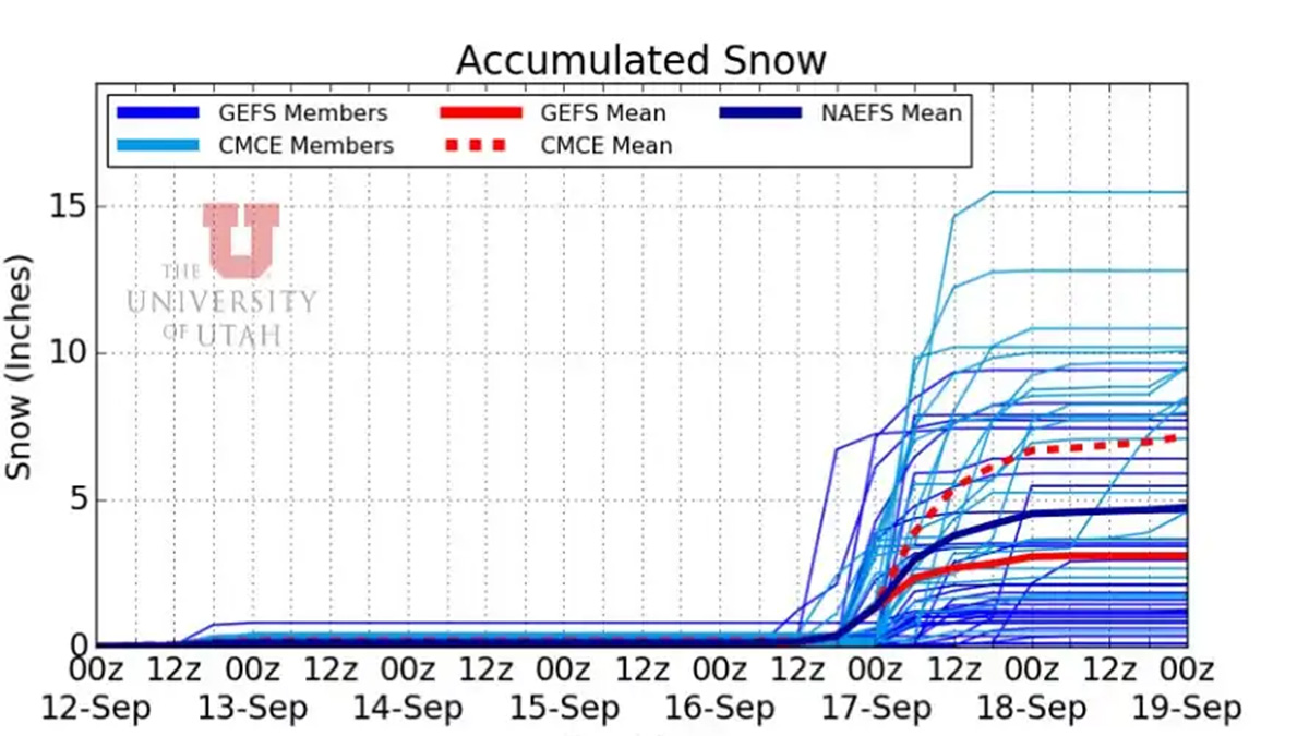
Photo: Powder Buoy
PARK CITY, Utah — Though last week’s first snow prediction didn’t amount to anything, local forecaster Powder Buoy has spread news of a possible dusting to a few inches of snow on Tuesday.
Weather in the Cottonwoods and at higher elevations on Tuesday and Wednesday calls for daytime highs in the high 30s and low 40s, with overnight lows of 32 and 34 degrees, paired with scattered thunderstorms.
Though the model shows totals near 15 inches for the event, the mean lines show a potential for up to six inches with a few inches likely.
View this post on Instagram
The Powder Buoy theory is this: Weather around the planet is connected, and storms that form or stream across the Pacific in the winter happen to cruise above Hawaii, bringing low-pressure systems and weather that will eventually hit the mainland. NOAA’s ocean buoys, managed by the National Buoy Data Center, provide 24/7 data on various metrics, including significant wave height. A spike in wave height signals low pressure, often indicating incoming storms. It typically takes two weeks for such weather to reach the western U.S. from the buoys. While not perfect, this system serves as an early warning for storms. High-pressure systems in Utah can redirect storms northward, but the buoy’s pattern offers useful insights for planning ski trips.
By: Marina Knight

325 White Pine Canyon Road
Park City, UT 84060
438 Castle Valley Drive
Castle Valley, UT 84532
2349 S Lava Vista Drive, Lot 32
Santa Clara, UT 84765
80 West 300 North
Salt Lake City, UT 84103
1511 S Valley View Circle
Springville, UT 84663
3267 W Deer Hollow Road, Unit 2305
Park City, UT 84060Talk of the Town


Park City Jobs

Hiring Barista Assistants and Baristas, Silver King Coffee
5 days ago Part time $17.00 - $30.00 hourly
General Maintenance Technician, Moose Management Vacation Rentals
9 days ago Full time

Office Coordinator, Park City Community Foundation
12 days ago Full time $50,000 - $55,000 yearly

Summit Land Conservancy Programs Specialist, Summit Land Conservancy
12 days ago Full time
Vice President of Finance, Park City Community Foundation
12 days ago Full time $115,000 - $130,000 yearly