Snow
Two feet of snow possible for the Wasatch tonight through Monday as impressive storm cycle begins
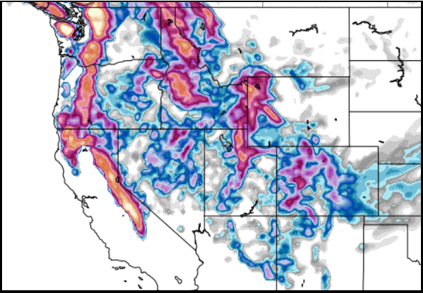
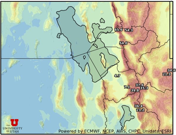
Photo: GFS model total snowfall through next Friday, January 9, 2026 shows totals approaching 3 feet in Utah // Pivotal Weather
This could be the weather pattern we’ve been waiting for all winter, with snow totals approaching 3 feet by the end of next week possible
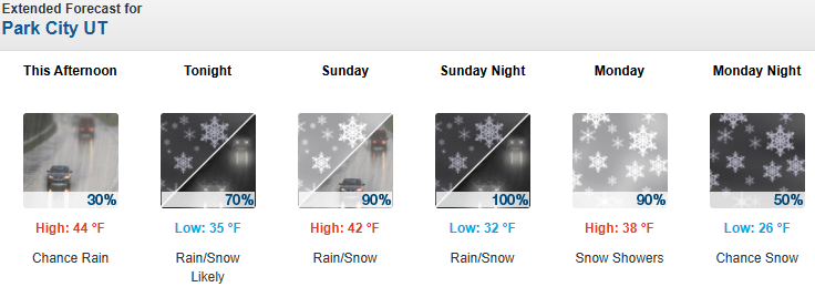
PARK CITY, Utah – Southwest winds are starting to increase Saturday afternoon as a multi-day storm system is set to impact Utah tonight through Monday. Snow levels will briefly increase to 8000 feet tonight as the main low-pressure center hangs out off the west coast and light mountain showers begin.
Expect to see a few inches of snowfall overnight as the first bit of moisture arrives. Snow levels should drop slightly Sunday and hang out around 7500 feet for most of the day. A second period of heavier snowfall begins Sunday evening through Monday morning as the next piece of the storm arrives, with snow levels beginning to drop overnight and finally bottoming out near 6000 feet by Monday evening.
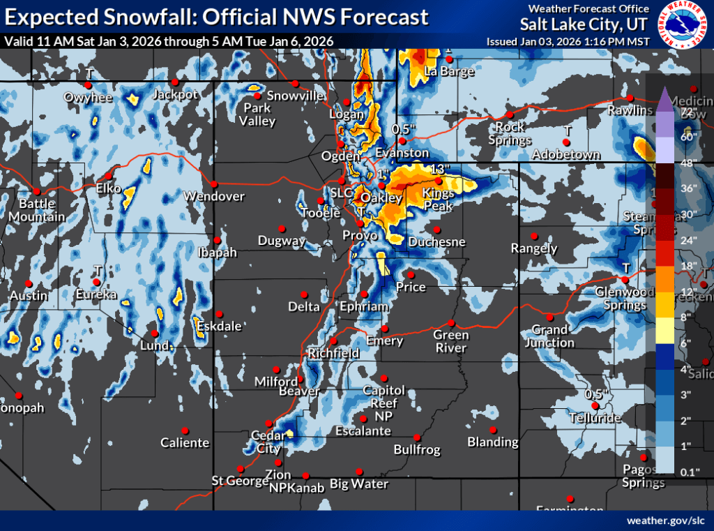
Forecast Snow Totals: Saturday – Monday
- Cottonwood Canyons: 14 – 24″
- PC Base/Town: 2 – 5″ (Monday)
- Deer Valley/PCMR: 8 – 16″
- N. Wasatch (Powder/Snowbasin): 9 – 18”
The last part of the storm arrives Monday with a shift to more westerly winds and a cold front pushing through with a final burst of enhanced snowfall. Snow showers look to mostly taper off by Monday evening, with an unsettled pattern lingering into Tuesday. The best chance for a few inches of snow in town is on Monday as the coldest air finally arrives and snow levels drop.
New Year’s Storm Recap
The New Year’s storm brought 7-14” of heavy, wet snow to the Wasatch last week, resulting in a chaotic Friday morning at the resorts in Little Cottonwood. A power outage occurred at Alta that essentially closed the Wildcat/Collins base area lifts, and the limited lifts operating at Snowbird were also delayed in opening, possibly due to icing. This resulted in extremely long lines as skier demand was at an all-time high during the holiday week, coupled with the fact that powder days have been scant this season.
Extended Outlook
The large-scale low-pressure center finally moves further inland on Tuesday but splits to the south from the main storm track. The lingering northerly part of the system clips Utah Tuesday next week, leaving a chance for some light mountain showers throughout the day. The second half of the week looks to be very active as most weather models are indicating a parade of storms dropping in from the northwest with even colder air, impacting Utah Wednesday through Friday with an additional foot of snow possible, and areas in the Northern Wasatch favored.
By: Adam Lenkowski

2349 S Lava Vista Drive, Lot 32
Santa Clara, UT 84765
80 West 300 North
Salt Lake City, UT 84103
438 Castle Valley Drive
Castle Valley, UT 84532
3267 W Deer Hollow Road, Unit 2305
Park City, UT 84060Talk of the Town


Park City Jobs

Computer / Website Assistant, Summit Support
4 days ago Part time $20.00 - $30.00 hourly

Garden Steward and Educator, Summit Community Gardens and EATS
4 days ago Seasonal
PROGRAM AND EVENT COORDINATOR, PC READS
5 days ago Part time $25.00 hourly
Development Manager, Blue Sky Utah
5 days ago Part time $28.00 - $32.00 hourly
Executive Assistant / Property Manager Administrator, Model HOA
5 days ago Full time $30.00 hourly