Weather
First storm of spring to drop a foot of snow across the Wasatch
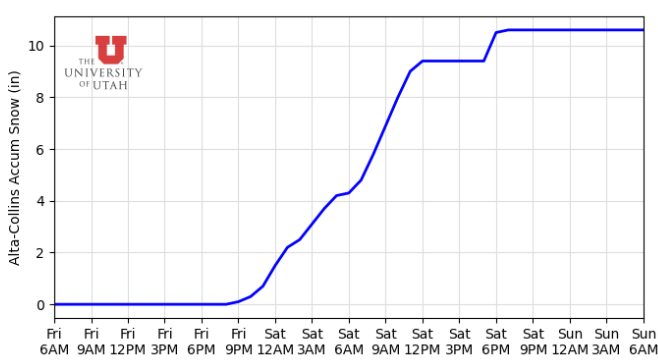
Photo: HRRR model total snow for Alta // UofU Dept. of Atmos. Science
Last chance for cold powder before way above normal temps take hold next week
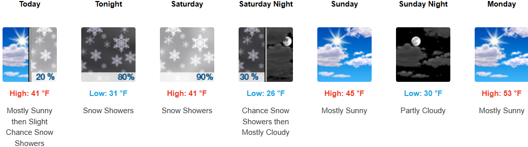
PARK CITY, Utah – A mild winter storm is approaching from the west even as days grow noticeably longer following the vernal equinox that marked the start of spring. Snow levels will rise to nearly 6,500 feet Friday and overnight into Saturday until a weak cold front moves into Utah late Saturday morning.
Snow in the higher terrain should begin afternoon Friday in the southwest flow, shifting to more west-northwest overnight into Saturday. Snowfall will begin to taper off Saturday night, with snow showers remaining in upper Little Cottonwood. In general, this will be a warmer storm with less snow accumulation than the recent March storms we’ve had. Park City may receive 1 – 3 inches of snow in town overnight Friday into Saturday.
Forecast mountain snow totals through Saturday night
- Park City / Deer Valley: 3-7”
- Alta/Snowbird (LCC): 8-14”
- Brighton/Solitude (BCC): 6-10”
- Snowbasin/Powder Mtn: 4-8”
Temperatures remain mild in the immediate wake of the storm on Sunday but quickly shift into high gear by Tuesday reaching 10-15 degrees above normal. High pressure and warm temps dominate through at least Thursday, with a chance of a storm Friday.
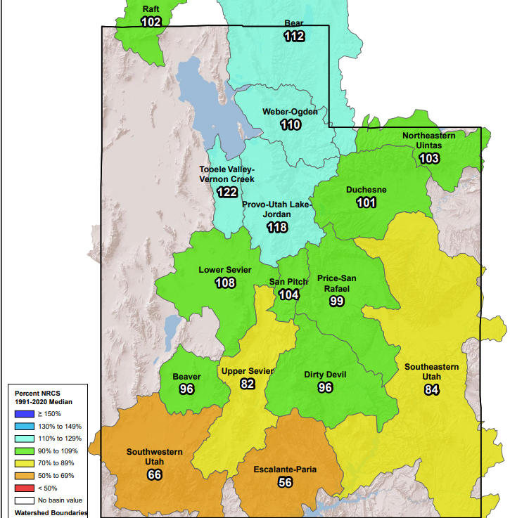
Current snowpack
Statewide, total snowpack is above normal after the recent barrage of storms that we’ve received in March, with northern Utah basins reporting over 110%. Southern Utah basin snow water equivalents (SWE) were absolutely dismal before the ‘Miracle March’ kicked in, reporting roughly only 20 – 30% of normal of the 30-year average. Alta receives an average of over 70” of snow in April, so there is still quite some time to keep adding to the snowpack at upper elevation locations.
By: Adam Lenkowski

80 West 300 North
Salt Lake City, UT 84103
438 Castle Valley Drive
Castle Valley, UT 84532
2349 S Lava Vista Drive, Lot 32
Santa Clara, UT 84765
3267 W Deer Hollow Road, Unit 2305
Park City, UT 84060Talk of the Town


Park City Jobs

Sales & Marketing Coordinator – B2B Publishing, Power Trade Media
Today Full time $40,000 - $45,000 yearly

Computer / Website Assistant, Summit Support
5 days ago Part time $20.00 - $30.00 hourly

Garden Steward and Educator, Summit Community Gardens and EATS
5 days ago Seasonal
PROGRAM AND EVENT COORDINATOR, PC READS
6 days ago Part time $25.00 hourly
Development Manager, Blue Sky Utah
6 days ago Part time $28.00 - $32.00 hourly