Weather
Incoming snow storm could drop over two feet in Park City
A major winter storm will hit the region Sunday through Tuesday. Photo: NWS
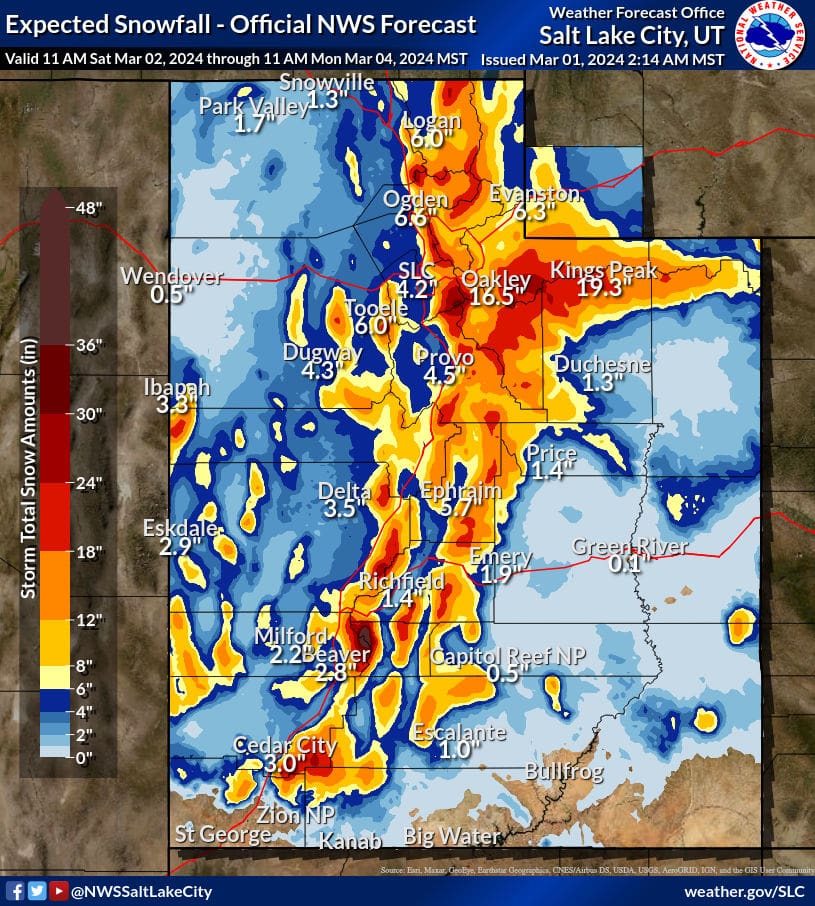
PARK CITY, Utah – It’s not over until, well, later this week anyway. Just when we thought winter storms might relent, some major weather is forecasted to drop up to 28 inches of snow in the mountains of Park City beginning Sunday through Tuesday. What’s more, the temperatures will be cold – in the teens and low 20s – before rising back into the 30s by Thursday.

For skiers and riders, the only remaining options are Solitude or Snowbird – and farther south Brian Head will also remain open through May 5.
The cold front and associated moisture will spread over the Wasatch starting Sunday. University of Utah models for Little Cottonwood Canyon show 5-10 inches by late Sunday increasing into Monday (Another 5-10) with perhaps 20 inches by the end of the day. Winds will be very strong Sunday with snow levels starting out high and temperatures dropping by the afternoon. Snow showers continue into Tuesday.
Open Snow’s forecast shows Park City picking up as much as 10 inches Sunday with temperatures starting out just above 30 degrees and dropping to 16 degrees by the end of the day. Monday through early Wednesday morning accumulations could total 18 inches, with up to 11 inches falling Tuesday, when temperatures will be winter-like.
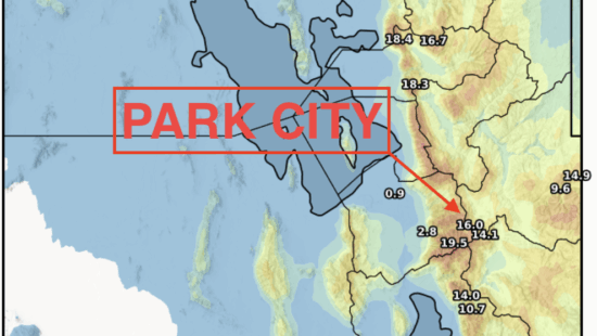
Local forecaster and spreader of stoke, Powder Buoy, posted the chart below showing accumulated snowfall for the incoming storm.
View this post on Instagram
By: Marina Knight

24 South 600 East
Salt Lake City, UT 84102
10584 Basin Canyon Road
Park City, UT 84098
19 East 100 North
Spring City, UT 84662
965 Goshen Canyon Road
Mona, UT 84645Talk of the Town


Park City Jobs
Social Media Videographer & Editor, Well Plated
1 day ago Contractor $3,000 - $5,000 monthly
Showroom Specialist, Tanner Glass & Hardware
1 day ago Full time $25.00 - $30.00 hourly

Head of Maintenance, Ptarmigan Property Services
1 day ago Full time $70,000 - $85,000 yearly

Assistant Manager, LOMA
8 days ago Full time $35.00 hourly
Property Inspector, Park City Rental Properties
9 days ago Full time $23.00 - $25.00 hourly