Weather
Cottonwoods could get up to 2 feet of snow in coming days
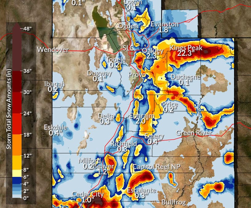
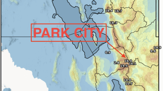
Expected snow totals through Feb. 7, 2024 Photo: NWS
PARK CITY, Utah — Park City and the surrounding ski resorts are gearing up for a significant stretch of winter weather. Alta and Snowbird could see 25″ of snow or more through Thursday, Feb. 8. Locally, in Park City, Deer Valley is forecast for 8″ and Park City Mountain 13″ through Thursday with a chance of more snow through the weekend.
Here’s what you need to know about the weather in Park City in the coming days.

Today’s Forecast: The day starts with a mix of snow and rain chances before 2 p.m., transitioning to a mostly cloudy sky. Temperatures are expected to hover near the 40-degree mark with a brisk south-southeast wind at around 17 mph. The chance of precipitation stands at 50%, with minimal snow accumulation anticipated during the day.
Tonight: The weather shifts to a mix of rain and snow, turning entirely to snow after 11 p.m. The temperature is expected to drop to around 30 degrees, accompanied by a south wind blowing at 11 to 18 mph. The likelihood of precipitation hits 100%, with less than an inch of new snow accumulation possible.
Midweek Weather: Wednesday welcomes more snow with a high near 36 degrees and south winds between 9 to 13 mph. The chance of precipitation remains at a solid 100%, with an inch of new snow likely. The snowy pattern continues into Wednesday night and Thursday, with accumulations ranging from 1 to 3 inches as temperatures dip to lows around 24 and highs near 32 degrees, respectively.
Looking Ahead: The forecast from Thursday night through Friday signals more snow, with chances ranging from 60% to 70%. Accumulations could add another 1 to 3 inches, bringing colder nights with lows dipping into the teens.
Weekend Outlook: The weekend offers a slight reprieve but maintains a chance of snow through Sunday. Daytime highs will peak near the upper 20s to low 30s, with night temperatures falling into the low teens. While snow chances decrease slightly, the possibility of fresh powder remains.
Ski Resort Anticipations: The local ski resorts are poised for significant snow. Deer Valley anticipates 12 inches of snow over the next five days, adding to the 13 inches received in the past 24 hours. Snowbird expects an impressive 22 inches, with Alta not far behind at 21 inches. Brighton and Solitude are also preparing for an 18-inch addition. Park City itself forecasts 13 inches of new snow, supplementing the 6 inches from the previous day.
Sign Up for First Chair: Kickstart your day with a concise summary of snowfall, weather, and the latest news. This email won’t flood your inbox daily; instead, subscribers can expect to receive First Chair around 7:00 a.m. on days when there’s significant snowfall (6 inches or more) – Sign Up Here
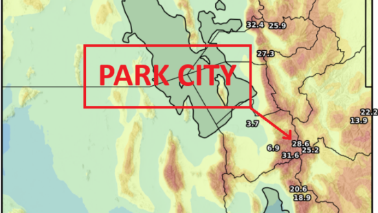
NOAA Utah Resort Snowfall Forecast through Feb. 8
| Low End Snowfall | Expected Snowfall | High End Snowfall | |
| Alta Ski Area, UT | 15 | 25 | 30 |
| Beaver Mountain, UT | 4 | 7 | 8 |
| Brian Head Resort, UT | 17 | 27 | 32 |
| Brighton Resort, UT | 11 | 20 | 26 |
| Canyons Village, UT | 5 | 8 | 16 |
| Cherry Peak Resort, UT | 6 | 8 | 10 |
| Deer Valley, UT | 5 | 9 | 18 |
| Eagle Point Resort, UT | 15 | 20 | 23 |
| Nordic Valley, UT | <1 | 2 | 6 |
| Park City Mountain Resort, UT | 6 | 13 | 19 |
| Powder Mountain, UT | 2 | 3 | 8 |
| Snowbasin Resort, UT | 3 | 5 | 9 |
| Snowbird Ski and Summer Resort, UT | 16 | 25 | 32 |
| Solitude Mountain Resort, UT | 8 | 16 | 22 |
| Sundance Mountain Resort, UT | 7 | 13 | 18 |
By: TownLift

80 West 300 North
Salt Lake City, UT 84103
3267 W Deer Hollow Road, Unit 2305
Park City, UT 84060
2349 S Lava Vista Drive, Lot 32
Santa Clara, UT 84765
438 Castle Valley Drive
Castle Valley, UT 84532Talk of the Town


Park City Jobs

Junior Interior Designer, Abigail Hill
2 days ago Contractor

Dental Assistant, Rise Dental Wellness
2 days ago Full time

Sales & Marketing Coordinator – B2B Publishing, Power Trade Media
4 days ago Full time $40,000 - $45,000 yearly

Computer / Website Assistant, Summit Support
9 days ago Part time $20.00 - $30.00 hourly

Garden Steward and Educator, Summit Community Gardens and EATS
9 days ago Seasonal