News
Deer Valley & PCMR report a foot of snow
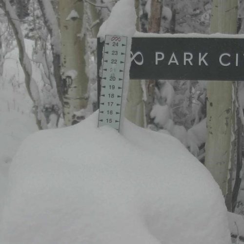
12 inches of fresh powder at Deer Valley on Tuesday morning. Photo: Deer Valley Resort
PARK CITY, Utah. — Park City got its first taste of snow on Monday night, as did the rest of Utah.
Another big storm impacting Utah this morning:
❄️11.5″ Logan
❄️11.0″ Solitude
❄️7″ Cedar City
❄️4″ Enoch
❄️3.3″ Park City
❄️2.7″ Newcastle
❄️1.8″ Oakley
❄️1.5″ Oak City
❄️1.0″ KanabMore reports in the link! #utwx https://t.co/hTJF8FYp8c
— NWS Salt Lake City (@NWSSaltLakeCity) October 12, 2021
The National Weather Service (NWS) is projecting more snow for the Park City area, on and off for the next few days.
Future forecast:
Today — Snow likely, mainly after 9 am. Mostly cloudy, with a high near 34. Northwest wind 11 to 13 mph. Chance of precipitation is 70%. Total daytime snow accumulation of less than one inch possible.
Tuesday Night — Snow, mainly before midnight. Low around 23. West wind 11 to 13 mph. Chance of precipitation is 80%. New snow accumulation of less than a half-inch possible.
Wednesday — A 20 percent chance of snow showers after noon. Partly sunny, with a high near 31. West southwest wind 7 to 10 mph.
Wednesday Night — Snow showers likely, mainly after midnight. Mostly cloudy, with a low around 25. West wind around 7 mph. Chance of precipitation is 70%. New snow accumulation of less than one inch possible.
Thursday — Snow showers likely, mainly before noon. Mostly cloudy, with a high near 28. West wind 8 to 11 mph. Chance of precipitation is 60%. New snow accumulation of 1 to 2 inches possible.
Thursday Night — Partly cloudy, with a low around 19.
Friday — Sunny, with a high near 35.
Friday Night — Mostly clear, with a low around 26.
View this post on Instagram
By: TownLift

3686 Spanish Valley Drive, Unit O1
Moab, UT 84532
3010 Silver Reef Drive
Leeds, UT 84746
10139 Summit View Drive
Park City, UT 84060
506 South 800 East
Salt Lake City, UT 84102
3149 East 10000 South
Sandy, UT 84092Talk of the Town


Park City Jobs
Superintendent/ working carpenter, RBCO INC
2 days ago Full time $38.00 - $42.00 hourly

Full time nanny for one toddler boy, N/A
12 days ago Full time $28.00 - $35.00 hourly
Buildings and Grounds Maintenance Assistant, National Ability Center
14 days ago Full time $20.00 - $22.00 hourly
Selling HVAC / Boiler Technicians, Team Cheever Plumbing and Heating
14 days ago Full time $44.00 hourly
Account Manager (part-time), Lemonade Education
17 days ago Part time $30.00 - $35.00 hourly