Environment
Utah snowpack drops to record low levels, including Summit County watersheds
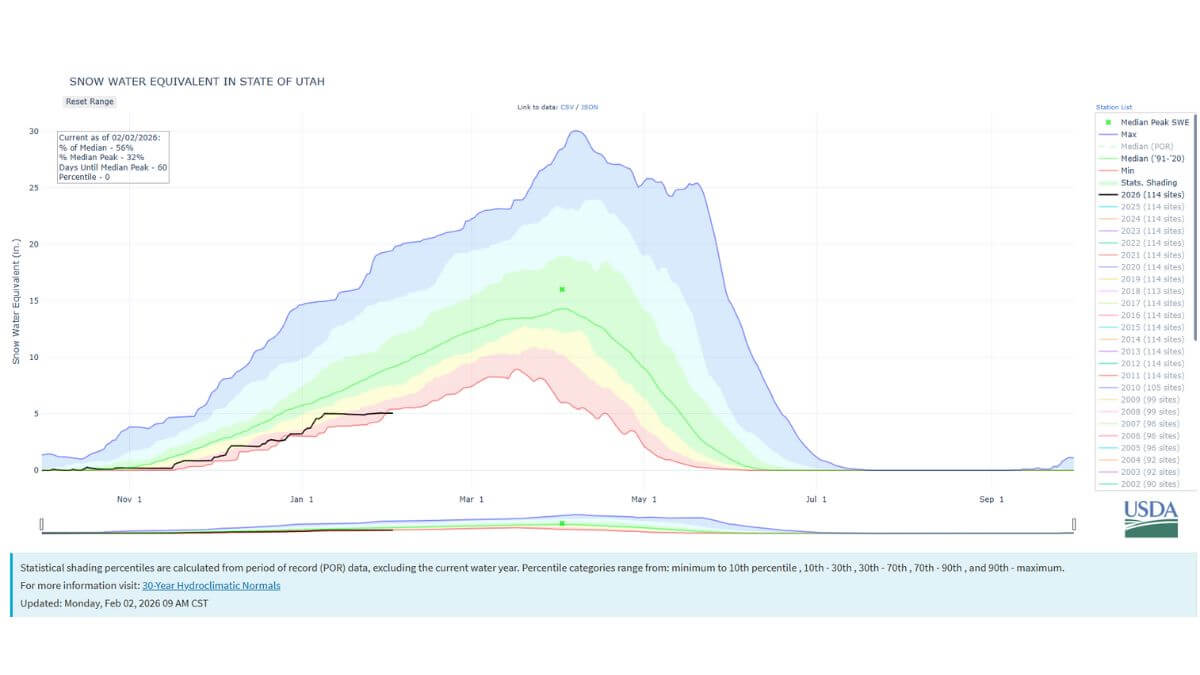
The black line shows Utah's 2026 statewide snowpack compared to other years' data. Photo: Natural Resources Conservation Service
UTAH — Punxsutawney Phil saw his shadow on Groundhog Day, predicting six more weeks of winter. But in Utah, it still feels like winter has yet to arrive. After weeks of clear and even smoggy skies, the state just set a new record low statewide snowpack, and six weeks maybe not be enough to mark a comeback. The season has only about two months left to accumulate snow before it begins to melt.
A special report from the Natural Resources Conservation Service (NRCS) distributed Monday noted the average statewide snow water equivalent (SWE) was 5.1 inches as of Jan. 31, dipping just below the previous minimum of 5.2 inches recorded during the SNOTEL era, which began in 1980.
Data compiled from the state’s SNOTEL monitoring network shows the severity of the deficit.
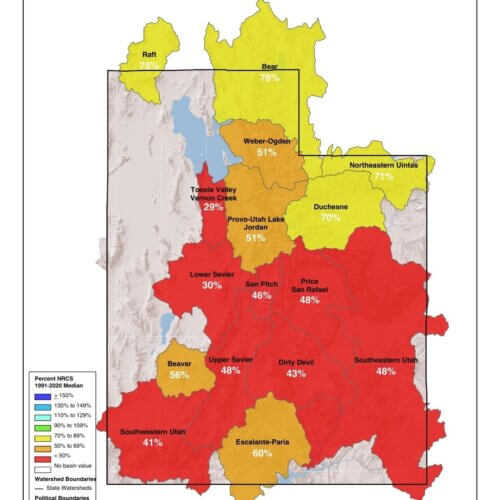
As of Saturday, 31 of Utah’s 140 SNOTEL sites were reporting a record low amount of SWE, while an additional 12 sites were reporting their second-lowest levels. Combined, nearly one-third of the state’s snow monitoring sites are currently experiencing their worst or second-worst snowpack conditions on record.
For Summit County, the record lows are particularly concerning, as the county sits at the headwaters of the Weber and Provo river systems and relies heavily on snowpack in the Uinta Mountains for downstream water supply.
Utah’s statewide SWE is currently measuring at roughly one-third of its normal annual peak. With only about two months remaining in the typical snow accumulation season, NRCS officials say it will take sustained, above-average snowfall to meaningfully close the gap.
By: Heather Bergeson

3267 W Deer Hollow Road, Unit 2305
Park City, UT 84060
438 Castle Valley Drive
Castle Valley, UT 84532
2349 S Lava Vista Drive, Lot 32
Santa Clara, UT 84765
80 West 300 North
Salt Lake City, UT 84103Talk of the Town


Park City Jobs

Junior Interior Designer, Abigail Hill
4 days ago Contractor

Dental Assistant, Rise Dental Wellness
4 days ago Full time

Sales & Marketing Coordinator – B2B Publishing, Power Trade Media
6 days ago Full time $40,000 - $45,000 yearly

Garden Steward and Educator, Summit Community Gardens and EATS
11 days ago Seasonal
PROGRAM AND EVENT COORDINATOR, PC READS
12 days ago Part time $25.00 hourly