Police & Fire
USU expert points to structure losses as key lesson from 2025 Utah fires
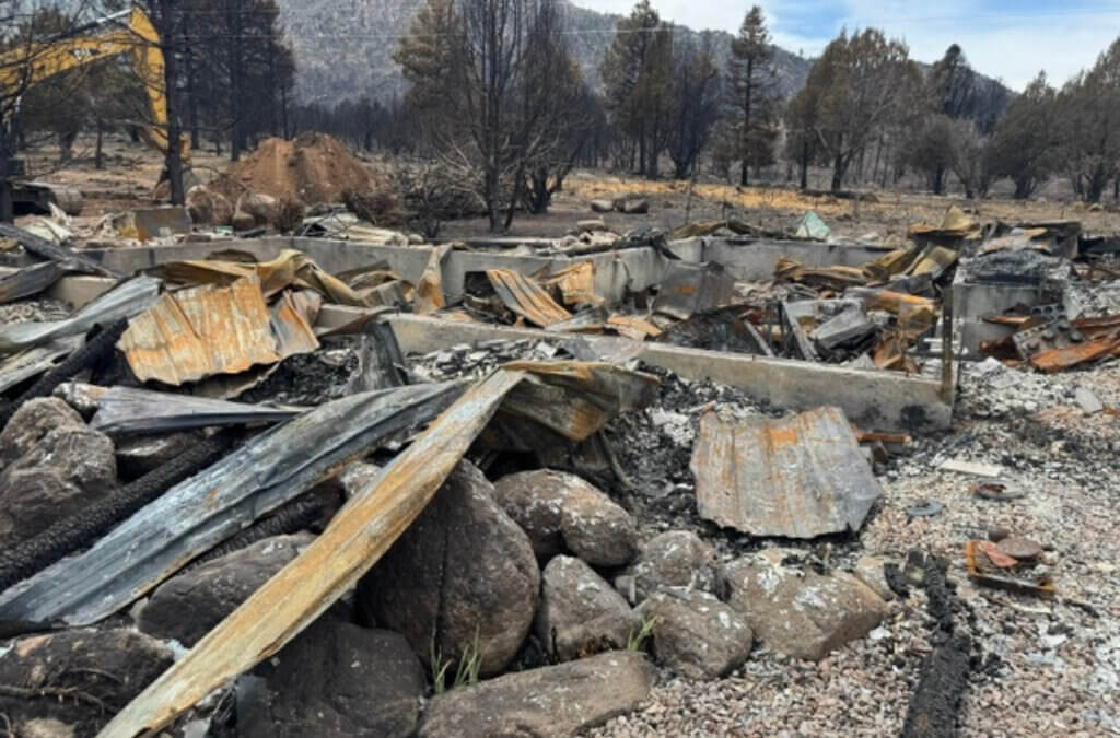
Debris from a burned structure is seen in the Pine Valley area after the Forsyth Fire in 2025. Utah State University Extension says the lightning-caused fire underscored the risks of living in the wildland-urban interface and the value of Firewise preparation. Photo: Utah State University
LOGAN, Utah — Utah’s 2025 wildfire season may not rank among the state’s worst by acres burned, but the number of structures damaged or destroyed offered a clear warning for residents living where neighborhoods meet wildland vegetation, a Utah State University Extension wildfire specialist said.
Brad Washa, an assistant professor of wildland fire science with USU Extension, pointed to a cluster of 2025 fires that destroyed homes, cabins, and other buildings, underscoring how quickly flames and embers can overwhelm communities in the wildland-urban interface, or WUI — the zone where development intermingles with undeveloped vegetation.
Among the most damaging incidents was the Forsyth Fire near Pine Valley in Washington County. Gov. Spencer Cox and fire officials said initial damage reports ranged from 13 homes lost to 14 homes plus outbuildings as assessments continued.
During a public meeting early in the Forsyth Fire, Pine Valley Fire Department Chief Robert Hardy urged residents to treat the blaze as a lesson.
“If there is one word you take away from this, it is ‘Firewise,’” he said.
Washa said the Pine Valley area reflects a broader reality across Utah and the West: homes have been built in “fire-dependent ecosystems,” where wildland fire has historically occurred. He said the Forsyth Fire was a natural ignition caused by lightning days before it fully emerged as a “holdover fire” in Forsyth Canyon.
“The Pine Valley fire is unique and concerning because wildfire has occurred regularly around that area, and steps were taken to help reduce the risk of wildfire,” Washa said. “This included a fuel break constructed around town after a similar fire in 2016.
“Did this fuel break perform as expected and reduce the fire’s behavior before it came near structures and town? I would say yes. For the number of structures lost in Pine Valley in 2025, many more were saved because of Firewise concepts homeowners used around their homes before the fire and because of firefighters’ efforts during the wildfire.”
Other 2025 fires also damaged buildings and displaced residents, according to published reports. The Deer Creek Fire near Old La Sal damaged or destroyed 13 structures, including a U.S. Forest Service guard station and a communications site, incident updates said. The Monroe Canyon Fire in central Utah destroyed 10 homes — primarily cabins and second homes — and four smaller structures, a public information officer told The Salt Lake Tribune. And a fast-moving Millcreek fire destroyed two apartment buildings and displaced 79 residents, officials said.
Washa said USU Extension recently released a video interview with Pine Valley residents and firefighters.
“We hope it better explains the risks and possible solutions for those living in the WUI,” he said. “Out of crisis, we can find learning opportunities.”
He said the Forsyth Fire video focuses on community resilience, while USU Extension also partnered with KUTV 2 News to highlight Firewise landscaping steps homeowners can take to reduce risk.
Those lessons are now arriving alongside a new state law that aims to shift more wildfire-prevention responsibility to property owners in high-risk areas. House Bill 48 — “Wildland Urban Interface Modifications” — took effect Jan. 1, 2026, requiring Utah’s Forestry, Fire, and State Lands division to maintain a high-risk WUI boundary map and setting up a fee-funded system of lot-level assessments and mitigation guidance.
Under HB 48, taxable structures within the high-risk boundary are subject to a fee ranging from $20 to $100 per structure in 2026 and 2027, based on square footage, with a triage-assessment component planned to begin in 2028. The law also requires insurers to use the state’s high-risk WUI boundary when labeling a property “high risk” for wildfire and, in some cases, to provide justification when rates rise sharply or coverage is dropped due to wildfire risk.
By: Rebecca Brenner

325 White Pine Canyon Road
Park City, UT 84060
1511 S Valley View Circle
Springville, UT 84663
80 West 300 North
Salt Lake City, UT 84103
3267 W Deer Hollow Road, Unit 2305
Park City, UT 84060
438 Castle Valley Drive
Castle Valley, UT 84532
2349 S Lava Vista Drive, Lot 32
Santa Clara, UT 84765Talk of the Town


Park City Jobs

Hiring Barista Assistants and Baristas, Silver King Coffee
1 day ago Part time $17.00 - $30.00 hourly
General Maintenance Technician, Moose Management Vacation Rentals
4 days ago Full time

Office Coordinator, Park City Community Foundation
8 days ago Full time $50,000 - $55,000 yearly

Summit Land Conservancy Programs Specialist, Summit Land Conservancy
8 days ago Full time
Vice President of Finance, Park City Community Foundation
8 days ago Full time $115,000 - $130,000 yearly