Weather
Utah on track for lowest snowpack on record, but a glimmer of hope remains for this week
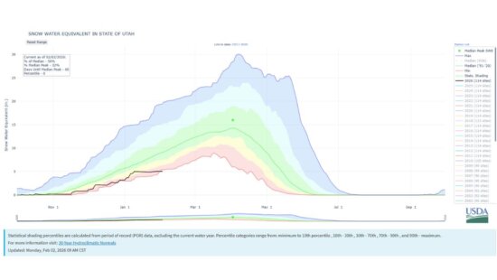
Photo: Utah Statewide – Snow Water Equivalent (percent of normal). Black line depicts current year 2025, approaching the lowest on record (red line) // USDA NRCS Snow Survey
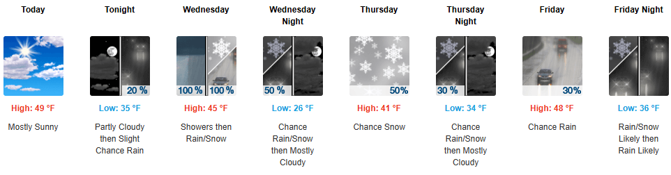
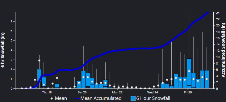
So you're saying there's a chance... Several small storm systems are set to impact the Wasatch starting Wednesday, possibly extending through the weekend.
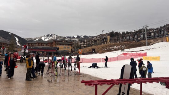
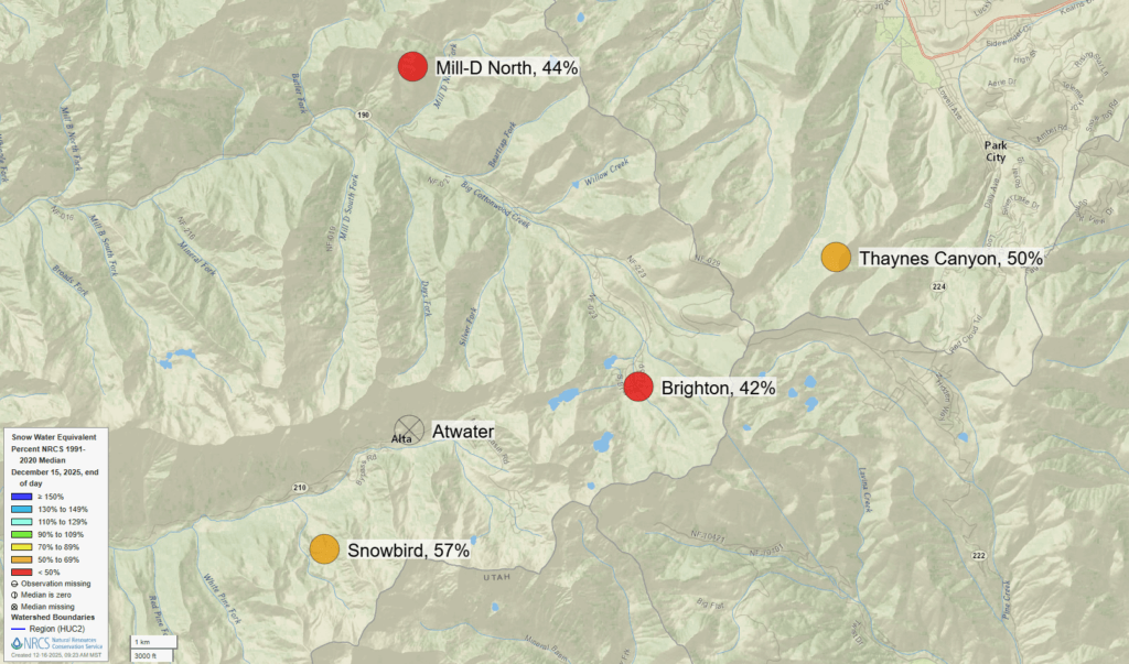
PARK CITY, Utah – It’s been a rough start to the 2025-26 winter season here in Utah, with statewide snowpack numbers now approaching the lowest on record as we enter the holiday stretch. Park City Mountain Resort and Deer Valley Resort are operating with the bare minimum amount of terrain open, with just 3% (10 out of 348) and 4% (8 out of 202) of trails available, respectively.
With a period of warm storms on tap starting Wednesday and possibly extending through the weekend, it will be a toss-up whether we will eclipse the historic low record or not in the next several days. The effect is twofold: we will gain some high water-content snow in elevations greater than about 8,000 feet, but rain will exacerbate snowmelt in the lower lying mountainous areas, with the two counteracting each other. It’s going to feel more like fall again in town, with highs in the 40s and lows in the 30s throughout much of the week.
Wednesday Storm
High clouds and some moisture are beginning to stream in today, signaling changes coming as the remnants of a surge of moist air from an atmospheric river interact with a weak system dropping in from our north on Wednesday.
Snow totals are expected to be modest, in the 2–5” range for the Central Wasatch. This is mostly due to snow levels starting out near 9,000 ft, resulting in heavy, dense snow. This will be accompanied by very strong westerly winds, approaching 45-mph sustained wind speeds and exceeding 75 mph gusts on the highest ridgelines of the mountains.
Snow levels will drop throughout the afternoon, with colder air finally moving in overnight Wednesday, as winds begin to shift to northwesterly. The system looks to dry out quickly, so unfortunately not much additional snowfall is expected during this time, but typical favored aspects in NW flow such as upper Little Cottonwood may see an additional inch or two.
Extended Outlook
As we stay in a generally unsettled, moist pattern, there is a slight chance of some snow showers in the mountains, which may drop an inch or so on Thursday.
The next larger storm system arrives Friday evening, which will yet again be warm, atmospheric river type moisture, keeping snow levels hovering around 8,000 ft in elevation.
Currently, the weather forecasting models are in slight disagreement on just how far south the jet stream and accompanying surge of moisture are going to penetrate into Utah. This is resulting in a bit of uncertainty with this system, but snow totals generally are expected to be in the 3–8” range, with light accumulations throughout the weekend.
La Niña Conditions / Long-Range Climate Forecast
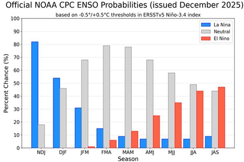
Weak La Niña conditions have returned in the short-term (colder than normal sea surface temperatures in the central Pacific Ocean), which generally result in warmer, drier conditions over the southwest US, and wetter conditions in the Pacific Northwest, as we’ve certainly seen with the historic flooding in Washington state.
While Utah sits in the transition zone, we have also experienced our share of warm, dry conditions, with record high temperatures for Salt Lake City in November and below average precipitation. The current La Niña period is forecast to give way to neutral conditions in the January-March period.
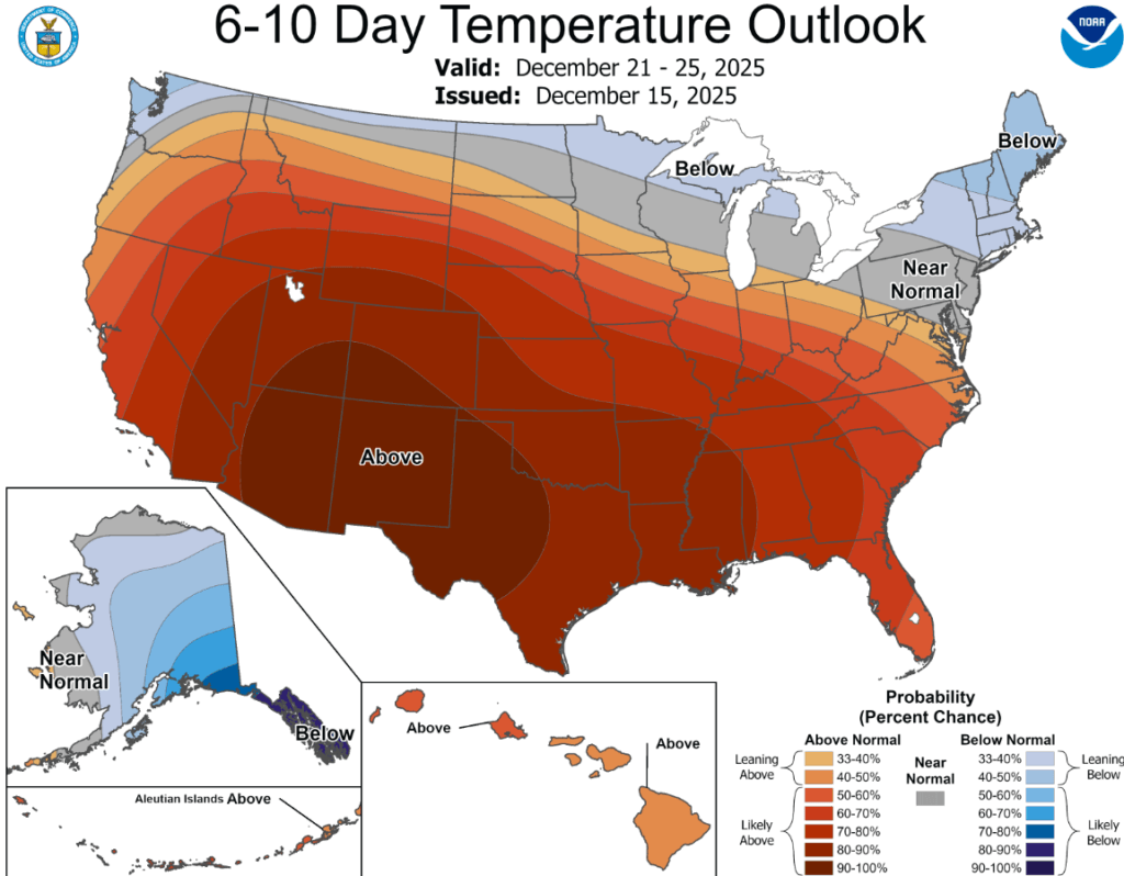
Long range climate and temperature forecasts do not bode well for Utah, as temperatures look to remain well above normal through nearly the end of December.
By: Adam Lenkowski

3267 W Deer Hollow Road, Unit 2305
Park City, UT 84060
438 Castle Valley Drive
Castle Valley, UT 84532
2349 S Lava Vista Drive, Lot 32
Santa Clara, UT 84765
80 West 300 North
Salt Lake City, UT 84103Talk of the Town


Park City Jobs

Junior Interior Designer, Abigail Hill
4 days ago Contractor

Dental Assistant, Rise Dental Wellness
4 days ago Full time

Sales & Marketing Coordinator – B2B Publishing, Power Trade Media
6 days ago Full time $40,000 - $45,000 yearly

Garden Steward and Educator, Summit Community Gardens and EATS
11 days ago Seasonal
PROGRAM AND EVENT COORDINATOR, PC READS
12 days ago Part time $25.00 hourly