Top Stories
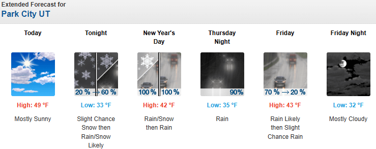
Highs near 50 degrees for Park City NYE, warm storm moving in overnight to kick off 2026
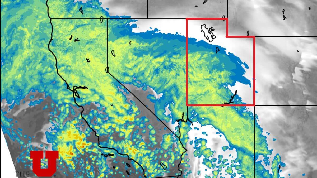
Photo: HRRR weather model at the midnight hour New Years shows precipitation on our doorstep as the storm approaches from the southwest // UofU Dept. of Atmospheric Sciences Photo:
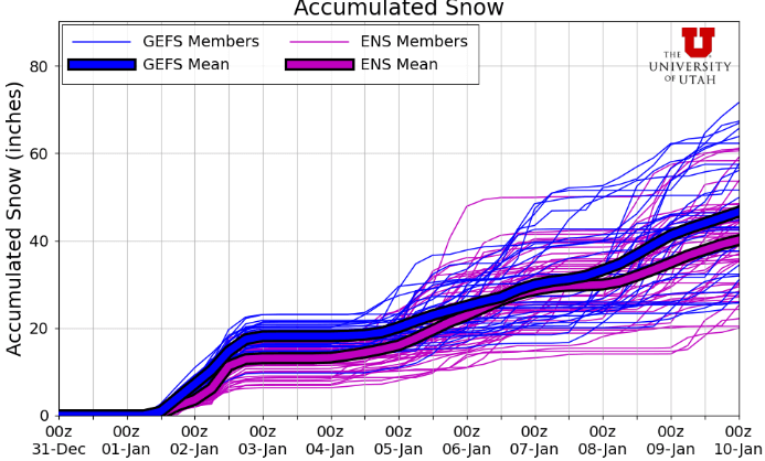
Up to a foot of snow is expected for areas of the Wasatch Mountains above 8500 feet New Year’s Day through Friday.
PARK CITY, Utah – Warm temperatures will prevail on New Year’s Eve with daytime highs near 50 degrees in Park City, as high pressure briefly builds into Utah ahead of a warm closed-low pressure system approaching from the south.
Light southerly winds will bring high clouds into the area on Wednesday, with precipitation expected to start after the clock strikes midnight and into the early morning hours.
This warm airmass will raise snow levels to near 8500 feet overnight, with rain/snow mix possible in town just as precipitation begins, but quickly becoming mostly rain.
The Salt Lake valley will likely remain fairly stagnant on Wednesday ahead of the storm system with colder, temperature inversion conditions, and another day of degraded air quality along with visible haze until the rain begins to scour it out overnight.
Forecast Snow Totals: Thursday – Friday
- Cottonwood Canyons: 7 – 14″
- PC Base/Town: T – 1″
- Deer Valley/PCMR: 5 – 9″
- N. Wasatch (Powder/Snowbasin): 6 – 12″
Mountain snow will remain wet and heavy due to the relatively warm air this moist storm is bringing in, with improved conditions at the higher elevations.
Snowfall should remain fairly consistent from early New Year’s Day through the afternoon, before a second wave comes in overnight Friday and into the morning as the center of the low tracks across central Utah. Snowfall looks to mostly taper off by the afternoon hours Friday. Snow levels will also begin to drop a bit during this later period closer to 7500 feet as the low draws in some colder air with it.
There is a chance for a period of northwest winds Friday that will favor upper Little Cottonwood and possibly boost the snow totals there. Accumulations may be limited in the Park City area mountains during the first part of the storm on Thursday due to the high snow levels, with a better chance of decent accumulations overnight Friday.
We’ll take what we can get at this point, but the broken record continues. This will be another warm storm with high snow levels and heavy base building type snow at upper elevations, but rain decimating the minimal existing snowpack on the lower mountain.
Extended Outlook
After this system exits the area late Friday into Saturday, there is a lull in activity but an active pattern looks to continue late Sunday into Monday, with a large low pressure digging south off the west coast and kicking up spits of moisture into Utah.
Things look to be quite uncertain after that, but generally the pattern remains active and the larger low-pressure center should move inland later in the week bringing additional precipitation. Long-range temperature forecasts continue with the warm trend into mid-January.
By: Adam Lenkowski

438 Castle Valley Drive
Castle Valley, UT 84532
80 West 300 North
Salt Lake City, UT 84103
3267 W Deer Hollow Road, Unit 2305
Park City, UT 84060
2349 S Lava Vista Drive, Lot 32
Santa Clara, UT 84765Talk of the Town


Park City Jobs

Sales & Marketing Coordinator – B2B Publishing, Power Trade Media
1 day ago Full time $40,000 - $45,000 yearly

Computer / Website Assistant, Summit Support
6 days ago Part time $20.00 - $30.00 hourly

Garden Steward and Educator, Summit Community Gardens and EATS
6 days ago Seasonal
PROGRAM AND EVENT COORDINATOR, PC READS
7 days ago Part time $25.00 hourly
Development Manager, Blue Sky Utah
7 days ago Part time $28.00 - $32.00 hourly