Weather
Early winter “whiplash”: Park City snowpack lags after record October precipitation
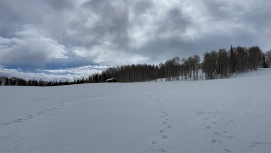
Clear skies on December 1, 2025, show a fresh coat of snow that arrived after a record-dry November. Photo: Park City Mountain Resort
Despite a record-wet October that fueled hopes for winter, Utah is entering December with lagging snowpack and shrinking reservoir levels after a warm, dry November.
PARK CITY, Utah — After a record-wet October had Utahns optimistic about a strong winter season, the state shifted sharply into warm and dry conditions through November, leaving the Park City area with a sluggish start to snowpack accumulation and below-normal reservoir levels heading into December.
The latest Utah Water Availability Update from the USDA Natural Resources Conservation Service (NRCS) describes the early 2026 water year as a story of “whiplash,” with October delivering 156% of normal mountain precipitation while November saw record-high temperatures and just 65% of normal precipitation. The Weber–Ogden watershed, which includes Park City’s nearby headwaters, reported just 57% of normal November precipitation.
As of Dec. 1, Utah’s statewide snowpack sits at 1.2 inches of snow-water equivalent, which is less than half of what’s normal for early December. Despite the slow start, hydrologists emphasize that it’s still too early in the season to draw conclusions.
“Snowpack accumulation doesn’t typically hit its stride until mid-winter,” the NRCS report notes, pointing to saturated mountain soils from October rains as a major positive. Wet soils reduce the amount of spring runoff that gets absorbed before reaching reservoirs.
Reservoirs are also seeing the impact of reduced precipitation, with Jordanelle sitting at 64% full (down from 80% last year). Across the entire Provo basin, storage averages 70% of capacity, compared to 84% at this time last year.
With limited early-December snow and above-normal temperatures, the immediate concern for locals is the effect on the start of the ski season. The October precipitation provided a strong baseline for the water year and should help maximize spring runoff, but the snowpack deficit will grow quickly if December and January remain dry.
The NRCS concludes with a familiar caution: keep conserving water. Winter could still deliver above-average snow, but until that arrives, storage levels remain vulnerable.
By: Heather Bergeson

80 West 300 North
Salt Lake City, UT 84103
2349 S Lava Vista Drive, Lot 32
Santa Clara, UT 84765
3267 W Deer Hollow Road, Unit 2305
Park City, UT 84060
438 Castle Valley Drive
Castle Valley, UT 84532Talk of the Town


Park City Jobs

Sales & Marketing Coordinator – B2B Publishing, Power Trade Media
1 day ago Full time $40,000 - $45,000 yearly

Computer / Website Assistant, Summit Support
5 days ago Part time $20.00 - $30.00 hourly

Garden Steward and Educator, Summit Community Gardens and EATS
5 days ago Seasonal
PROGRAM AND EVENT COORDINATOR, PC READS
6 days ago Part time $25.00 hourly
Development Manager, Blue Sky Utah
6 days ago Part time $28.00 - $32.00 hourly