Weather
Splitting storm to impact Utah on Sunday, more snow possible later in the week
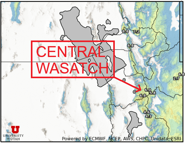
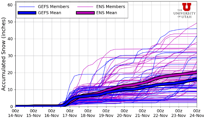
Photo: Utah Snow Ensemble model total snowfall through Monday // UofU Dept. of Atmos. Sciences
3-7” of snow is expected for the Wasatch Mountains on Sunday through Monday
PARK CITY, Utah – It’s been an unusually warm and dry start to November, after October made headlines for setting a record for monthly precipitation. Many ski resorts are waiting for colder temperatures to turn on their snow guns, but there is some hope on the horizon as a closed-low system is set to impact Utah on Sunday.
Earlier in the week, most forecast models were pushing for this system to track directly across Utah. Today, that story has changed significantly. Instead, the storm has become a cutoff-low, isolated from the main jet stream flow, and is currently spinning off the southern coast of California.
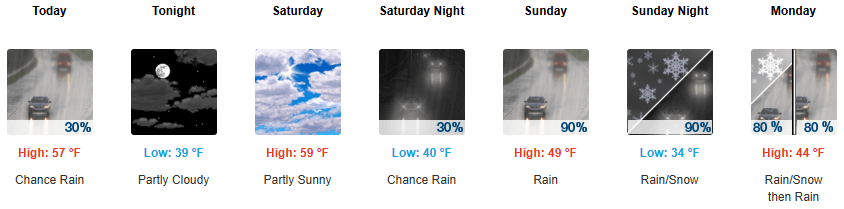
Gusty southwest winds are already streaming in some clouds and moisture today, with calmer winds and a break in activity expected for Saturday. By Sunday, the low-pressure center is expected to finally begin tracking across the Southwest U.S. and eventually into Utah. This is a relatively warm storm, with snow levels initially starting out around 9,500 feet Saturday night and slowly dropping to near 7,000 by Monday morning.
Forecast snow totals Sunday – Monday
- Cottonwood Canyons: 3 – 7″
- PC Base/Town: T – 1″
- Deer Valley/PCMR: 2 – 6″
- N. Wasatch (Powder/Snowbasin): 3 – 7″
These types of storms are notoriously difficult to forecast, and they don’t follow the typical pattern we hope for in order to generate big accumulations here in the Wasatch. The winds remain south to southwesterly the whole time, and never quite switch around to the west/northwest with a typical cold frontal passage. The best chance for precipitation and the heaviest snow looks to be Sunday afternoon through Monday morning, with a chance of some flurries in town as the coldest air moves in.
Extended outlook
After a slight lull in activity Monday night into Tuesday, unsettled weather is expected to continue Tuesday night through Wednesday. However, there is considerable uncertainty between the different forecast models currently, with some bringing a similar southerly tracking closed-low through the region and others hinting at a glancing blow from the north.
By: Adam Lenkowski

325 White Pine Canyon Road
Park City, UT 84060
80 West 300 North
Salt Lake City, UT 84103
1511 S Valley View Circle
Springville, UT 84663
438 Castle Valley Drive
Castle Valley, UT 84532
3267 W Deer Hollow Road, Unit 2305
Park City, UT 84060
2349 S Lava Vista Drive, Lot 32
Santa Clara, UT 84765Talk of the Town


Park City Jobs

Hiring Barista Assistants and Baristas, Silver King Coffee
1 day ago Part time $17.00 - $30.00 hourly
General Maintenance Technician, Moose Management Vacation Rentals
5 days ago Full time

Office Coordinator, Park City Community Foundation
8 days ago Full time $50,000 - $55,000 yearly

Summit Land Conservancy Programs Specialist, Summit Land Conservancy
8 days ago Full time
Vice President of Finance, Park City Community Foundation
8 days ago Full time $115,000 - $130,000 yearly