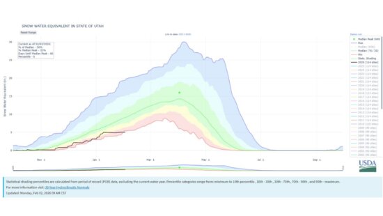
Snow
Enjoy the warmer temps and sunshine for Thanksgiving, light snow expected for the weekend as two small storms impact Utah
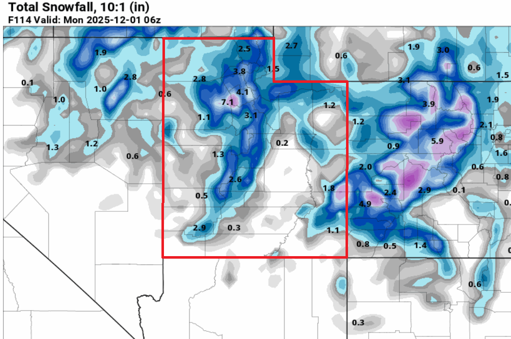
Photo: GFS model total snowfall through Monday, December 1, 2025// Pivotal Weather
2-5” of snow is expected for the Wasatch Mountains - Friday night through Sunday
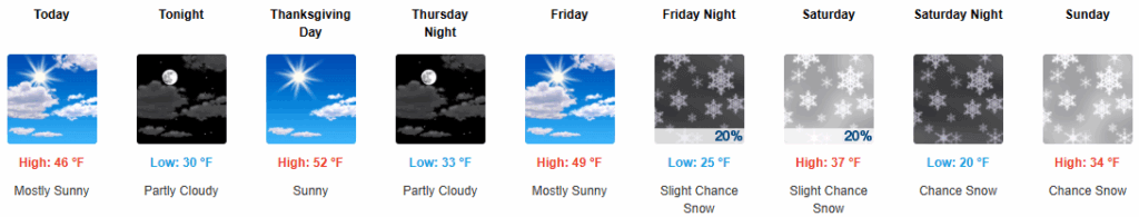
PARK CITY, Utah – Partly cloudy skies today will give way to warm temperatures and sunshine, as high pressure builds into the area for the Thanksgiving holiday. The warm, dry November trend continues, with the official NWS Salt Lake City International Airport weather station reporting just 28% of normal precipitation for the month so far.
Temperatures will be about 5-10 degrees F above normal through Friday, but changes are on the way for the weekend.
A glancing storm to our north will set off light mountain showers overnight Friday into Saturday, with little accumulation expected. However, temperatures will begin to cool down as a second, stronger part of the larger low-pressure system approaches.
Sunday will bring in colder air and the best chances for any significant snow accumulation, as this storm tracks more directly through Utah, with snow levels potentially dropping down as low as the Salt Lake Valley benches. Snowfall looks to taper off Sunday night into Monday morning.
Forecast Snow Totals: Friday night – Sunday night
- Cottonwood Canyons: 2 – 5″
- PC Base/Town: T – 1″
- Deer Valley/PCMR: 1 – 3″
- N. Wasatch (Powder/Snowbasin): 2 – 5″
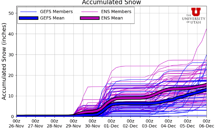
Extended Outlook
After the storm system exits the region on Monday, the long-range forecast models are hinting at another winter storm potentially impacting Utah midweek.
By: Adam Lenkowski

3267 W Deer Hollow Road, Unit 2305
Park City, UT 84060
2349 S Lava Vista Drive, Lot 32
Santa Clara, UT 84765
438 Castle Valley Drive
Castle Valley, UT 84532
80 West 300 North
Salt Lake City, UT 84103Talk of the Town


Park City Jobs

Junior Interior Designer, Abigail Hill
4 days ago Contractor

Dental Assistant, Rise Dental Wellness
4 days ago Full time

Sales & Marketing Coordinator – B2B Publishing, Power Trade Media
7 days ago Full time $40,000 - $45,000 yearly

Garden Steward and Educator, Summit Community Gardens and EATS
11 days ago Seasonal
PROGRAM AND EVENT COORDINATOR, PC READS
12 days ago Part time $25.00 hourly