Snow
“Avalanches are officially on the menu” as Utah’s thin snowpack produces early-season slide

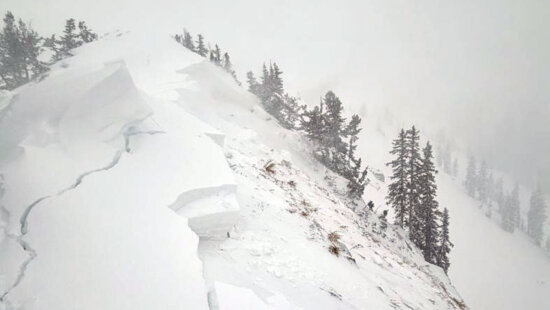
One foot of drifted snow broke loose above a bed of rocks and bare ground on this northeast-facing slope, showing how little coverage it takes for early-season terrain to produce an avalanche. Photo: UAC // Brooke Maushund
The UAC said the thin snowpack and exposed terrain created an unforgiving environment, with rocks just below the surface increasing the consequences of even a small slide.
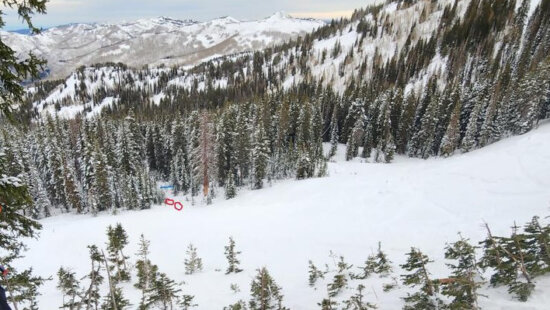
The Utah Avalanche Center confirmed a human-triggered avalanche Saturday on a high-elevation slope in the Red Pine area of Little Cottonwood Canyon, underscoring the early-season instability developing across the mountains.
The slide occurred on a northeast-facing slope at roughly 10,400 feet, just below a wind-loaded ridgeline. According to UAC forecaster Brooke Maushund, a rider descending the slope triggered the avalanche, which broke more than a foot deep and approximately 150 feet wide. It failed on a layer of faceted snow sitting above rocky early-season ground.
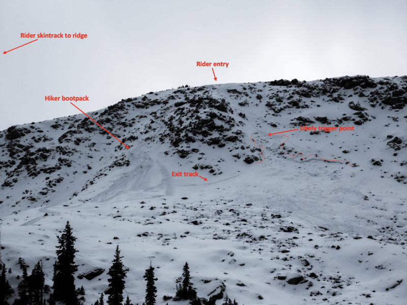
Recent strong southwest winds drifted additional snow into the area, creating a stiff slab over the weak layer. Maushund visited the site Sunday to inspect the crown and debris.
No injuries were reported. The rider was able to escape the moving snow.
The UAC said the thin snowpack and exposed terrain created an unforgiving environment, with rocks just below the surface increasing the consequences of even a small slide. Forecasters warned that people seeking early-season turns should treat avalanche terrain the same as midwinter.
“Avalanches are officially on the menu,” the center said in its report.
For the most current avalanche forecast, go to https://utahavalanchecenter.org/forecast/salt-lake
By: TownLift

2349 S Lava Vista Drive, Lot 32
Santa Clara, UT 84765
80 West 300 North
Salt Lake City, UT 84103
3267 W Deer Hollow Road, Unit 2305
Park City, UT 84060
438 Castle Valley Drive
Castle Valley, UT 84532Talk of the Town


Park City Jobs

Computer / Website Assistant, Summit Support
4 days ago Part time $20.00 - $30.00 hourly

Garden Steward and Educator, Summit Community Gardens and EATS
4 days ago Seasonal
PROGRAM AND EVENT COORDINATOR, PC READS
5 days ago Part time $25.00 hourly
Development Manager, Blue Sky Utah
6 days ago Part time $28.00 - $32.00 hourly
Executive Assistant / Property Manager Administrator, Model HOA
6 days ago Full time $30.00 hourly