Weather
Another early season tease as the Wasatch get glancing blow from winter storm on Sunday
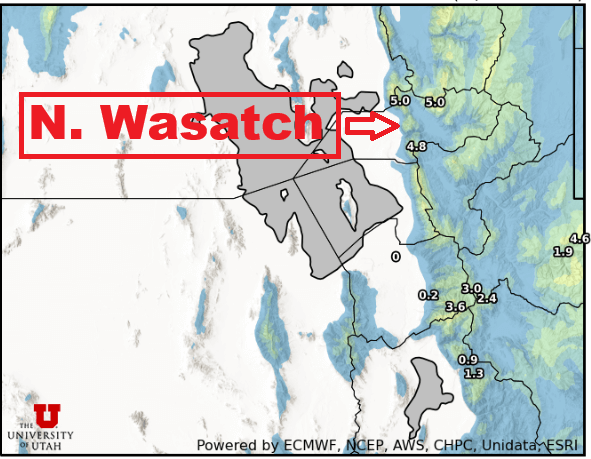
Photo: Utah Snow Ensemble model total snowfall through Monday // UofU Dept. of Atmos. Sciences
2 - 6” of snow is expected for the Wasatch Mountains on Sunday through Monday morning
PARK CITY, Utah – A large low-pressure system and associated atmospheric river is clobbering the Pacific Northwest / Northern California currently; however, this part of the storm will stay to our north and decay as it moves inland.
A second piece of energy and burst of moisture is forecast to impact Utah starting Sunday morning in southwesterly flow, with showers starting in the mountains as moisture begins to trickle in, and colder air moving in throughout the day. Snow levels will start out high, above 8,000 ft, and slowly drop to near 6500 ft by early Monday morning. The strongest snowfall will be overnight Sunday into Monday morning as the coldest air finally arrives, bringing a chance of about an inch of snow to the Park City base area and town.
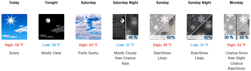
Forecast Snow Totals: Sunday – Monday
- Cottonwood Canyons: 2 – 6″
- PC Base/Town: T – 2″
- Deer Valley/PCMR: 2 – 4″
- N. Wasatch (Powder/Snowbasin): 3 – 7″
Once again, we are right on the southern edge of a somewhat narrow band of moisture associated with this storm.
Winds never quite shift northwesterly and are forecast to be mainly westerly as the cold front passes Sunday evening. This could slightly favor the northern Wasatch mountains, including Powder Mountain and Snowbasin. Any potential lake effect or lake enhancement that occurs would also be focused in this area, although there is only a slight chance.
Extended Outlook
The pattern remains very active for the Pacific Northwest as at least two more significant storms are possible later this week; however, things are looking dry for us here in Utah as seasonal temperatures return through at least Thursday.
One of the models is hinting at a weak brush by storm later in the week, but most remain dry through next weekend.
By: Adam Lenkowski

438 Castle Valley Drive
Castle Valley, UT 84532
80 West 300 North
Salt Lake City, UT 84103
2349 S Lava Vista Drive, Lot 32
Santa Clara, UT 84765
3267 W Deer Hollow Road, Unit 2305
Park City, UT 84060Talk of the Town


Park City Jobs

Sales & Marketing Coordinator – B2B Publishing, Power Trade Media
1 day ago Full time $40,000 - $45,000 yearly

Computer / Website Assistant, Summit Support
5 days ago Part time $20.00 - $30.00 hourly

Garden Steward and Educator, Summit Community Gardens and EATS
6 days ago Seasonal
PROGRAM AND EVENT COORDINATOR, PC READS
6 days ago Part time $25.00 hourly
Development Manager, Blue Sky Utah
7 days ago Part time $28.00 - $32.00 hourly