Environment
Beulah Fire grows to 1,000 acres in Uinta Wilderness, level 3 evacuations in effect

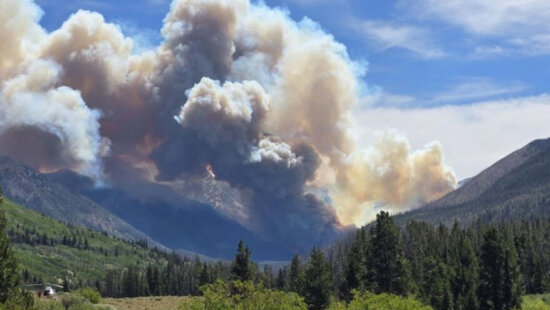
The Beulah Fire spread from an estimated 300-400 acres to 1,500 acres as of Friday morning. Photo: U.S. Forest Service Uinta-Wasatch-Cache National Forest
Campers fled the area Thursday as winds fanned the fire and flames spread rapidly
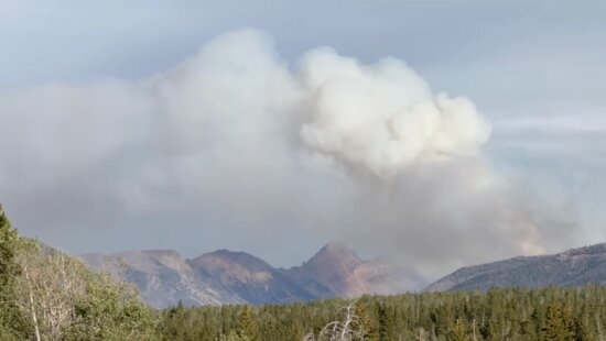
SUMMIT COUNTY, Utah — The Beulah Fire burning in the Uinta Wilderness has spread rapidly to approximately 1,000 acres as of Friday morning, with nearly 900 acres still actively burning, according to data from aerial mapping conducted by intelligence aircraft.
Approximately 140 people are working the fire engaged in full suppression activity. Structure protection at the Hinckley Boy Scout Camp will be a priority today.
The wildfire, located in Summit County near the Wyoming border, about 7.5 miles southeast of the Bear River Ranger Station on the north slope of the Uinta Mountains, was first reported Wednesday by the U.S. Forest Service as covering 200 acres. Within just 13 hours, the blaze rapidly grew, fueled by dry vegetation, rugged terrain, and hot, windy conditions.
Officials from the Evanston and Mountain View Ranger Districts of the Uinta-Wasatch-Cache National Forest confirmed resources are on scene, and additional firefighting crews and support assets have been requested to help contain the fire.
Level 3 evacuation orders—meaning “Go Now”—have been issued for the Bear River and Mill Creek drainages. Importantly, the Mill Creek area under evacuation refers to a tributary of the East Fork Bear River, not Millcreek Canyon near Salt Lake City.
View this post on Instagram
View this post on Instagram
Campers evacuated from the fire area
Utah news anchor Brian Schnee posted a video to Instagram showing campers evacuating from the Beulah Fire asa a DPS helicopter flies overhead. Officials reported Wednesday that helicopters were being used to evacuate campers who were caught near the fire.
“We saw these backpackers running down the road as we were evacuating,” Thomas Mackay, who evacuated the area Wednesday.
Fox 13 spoke to a man who was evacuated from the Allsop Lake area on Wednesday afternoon. Jason Vaneps was caught in an area that quickly became surrounded by flames.
“Once I knew I couldn’t get out, I was waving my shirt and everything else,” Vaneps told Fox 13.
Evacuations were also being conducted at the Lyman Lake area, according to Watch Duty.
For public safety, several roads and access points have been closed, including:
- North Slope Road at the West Fork of the Blacks Fork, East Fork of the Bear River, and Mill Creek
- Elizabeth Ridge Road
- Elizabeth Pass Road
The fire is burning near a remote area popular for camping, hiking, and fishing, particularly during the summer months. No structural damage has been reported as of Thursday morning, but Forest Service officials are urging visitors and residents in the area to avoid backcountry travel and adhere to all evacuation orders and closures.
Aerial support is playing a crucial role in mapping and assessing the fire’s behavior. Trident Sensing aircraft have provided updated thermal imaging showing active burn perimeters and spread potential.
The Beulah Fire comes amid heightened fire activity across the western United States. On Monday, the National Interagency Fire Center raised the national preparedness level to PL4, citing increasing fire activity and stretched firefighting resources. Conditions across the Intermountain West remain favorable for fire growth, with dry fuels and unstable weather patterns forecast to continue.
Summit County officials and the U.S. Forest Service are expected to provide additional updates as more resources arrive and suppression efforts intensify.
Anyone in the area should monitor evacuation alerts, road closures, and fire conditions through official channels, Summit County and the U.S. Forest Service.
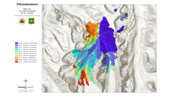
Editors Note: The fire size has been updated from 1,500 to 1,000 acres as more accurate mapping information is now available.
By: Marina Knight

1271 Lowell Avenue, C202
Park City, UT 84060
4170 Vista Antigua Road
Moab, UT 84532
4028 E Outcrop Road
Park City, UT 84098
1104 West 10125 South
South Jordan, UT 84095
1355 E Snow Canyon Parkway, Lot 27
Ivins, UT 84738
4155 S Parkview Drive
Salt Lake City, UT 84124Talk of the Town


Park City Jobs

SENIOR HOA BOOKKEEPER WANTED, Compass Management Services
1 day ago Full time

Systems Administrator, Basin Recreation
5 days ago Full time $70,645 - $88,306 yearly
Accounts Payable Lead Coordinator, Basin Recreation
5 days ago Full time $58,871 - $73,588 yearly

Logistics Specialist, PACIFICORP
6 days ago Full time $28.71 hourly
Maintenance Tech, Utah Olympic Park
6 days ago Full time $20.00 - $24.00 hourly