Weather
Significant winter storm arriving President’s Day weekend, 1 to 3 feet of snow forecast
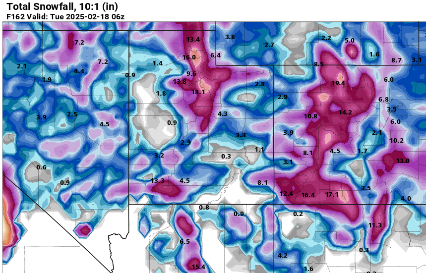
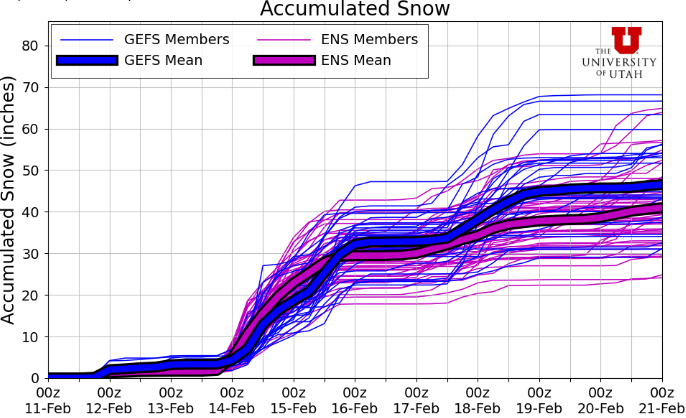
GFS model total snowfall through Monday night. Photo: Pivotal Weather
Light snow and freezing cold temperatures for Park city today, major winter storm Thursday through Saturday
PARK CITY, Utah – Light snow has moved into northern Utah this morning as a weak storm is grazing the state. The major impact of this system will be the extremely cold air that will arrive overnight in the wake of this weak cold front. Snow accumulations should be minor, with only an inch or two expected across northern valleys and the Wasatch. Temperatures will drop to near and below-zero degrees F for the town of Park City and across the mountains overnight and remain extremely cold through Thursday morning.
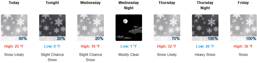
Things begin to ramp up Thursday morning as the major winter storm approaches from southern California, bringing strong southerly winds and warming temperatures. Abundant moisture will be available as this storm taps into an atmospheric river off the coast. Snowfall is expected to begin Thursday afternoon, with the heaviest snow occurring overnight Friday as the main part of the storm moves over Utah. The winds eventually turn west to northwest on Friday evening into Saturday, keeping mountain snow showers going into the evening with enhanced totals for the Cottonwoods through this period.
Snowfall totals Thursday through Saturday night
- Big/Little Cottonwood: 20-36″
- PCMR/Deer Valley: 12-24″
- PC Base/Town: 6-12″
After a brief lull in activity Saturday night into Sunday, forecast models are hinting at another weaker storm system to impact northern Utah Sunday night into President’s Day.
By: Adam Lenkowski

2349 S Lava Vista Drive, Lot 32
Santa Clara, UT 84765
3267 W Deer Hollow Road, Unit 2305
Park City, UT 84060
438 Castle Valley Drive
Castle Valley, UT 84532
80 West 300 North
Salt Lake City, UT 84103Talk of the Town


Park City Jobs

Junior Interior Designer, Abigail Hill
4 days ago Contractor

Dental Assistant, Rise Dental Wellness
4 days ago Full time

Sales & Marketing Coordinator – B2B Publishing, Power Trade Media
6 days ago Full time $40,000 - $45,000 yearly

Garden Steward and Educator, Summit Community Gardens and EATS
11 days ago Seasonal
PROGRAM AND EVENT COORDINATOR, PC READS
12 days ago Part time $25.00 hourly