Weather
Dreaming of a White Christmas? 6 inches of snow forecasted for Park City ski resorts
Photo: TownLift // Rayne Moynahan
PARK CITY, Utah — With 51-degree temperatures in Park City this week, Santa received many requests for a snowy Christmas – It just might happen!
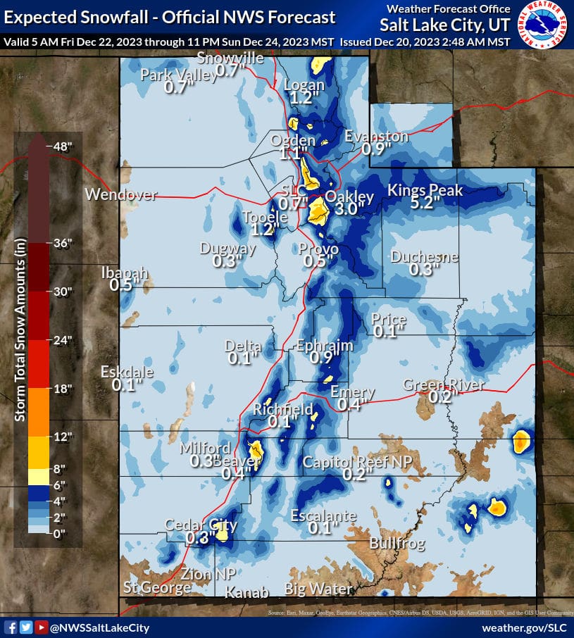
NOAA is currently forecasting a storm to hit Park City starting on Friday, Dec. 22, through Sunday, Dec. 24, with up to 6″ of new snow at Park City ski resorts Deer Valley and Park City Mountain. Alta and Snowbird could see between 10″ and 11″ of snow through Christmas Eve. In town, 1-3 inches of snow is possible.
Powderbuoy also appears to be optimistic for this weekend, sharing in a post, “We may have a few more dribs and drabs before this weekend when the storm looks to be coming in for Christmas Eve”
This a reminder that First Chair, Townlift’s newest newsletter, delivers a concise summary of snowfall, weather, and the latest news. This email won’t flood your inbox daily; instead, subscribers can expect to receive First Chair around 7 a.m. on days when there’s significant snowfall (six inches or more) – Sign up here.
NOAA Regional Ski Resort Snowfall forecast through 12/24
| Low End Snowfall | Expected Snowfall | High End Snowfall | |
| Alta Ski Area, UT | 5 | 11 | 11 |
| Beaver Mountain, UT | 3 | 6 | 6 |
| Brian Head Resort, UT | 3 | 8 | 8 |
| Brighton Resort, UT | 4 | 9 | 9 |
| Canyons Village, UT | 3 | 7 | 7 |
| Cherry Peak Resort, UT | 3 | 6 | 6 |
| Deer Valley, UT | 2 | 5 | 6 |
| Eagle Point Resort, UT | 5 | 7 | 7 |
| Nordic Valley, UT | 2 | 4 | 4 |
| Park City Mountain Resort, UT | 3 | 6 | 6 |
| Powder Mountain, UT | 2 | 5 | 5 |
| Snowbasin Resort, UT | 3 | 5 | 6 |
| Snowbird Ski and Summer Resort, UT | 5 | 10 | 10 |
| Solitude Mountain Resort, UT | 5 | 9 | 9 |
| Sundance Mountain Resort, UT | 2 | 5 | 5 |
View this post on Instagram
By: TownLift

965 Goshen Canyon Road
Mona, UT 84645
19 East 100 North
Spring City, UT 84662
24 South 600 East
Salt Lake City, UT 84102
10584 Basin Canyon Road
Park City, UT 84098Talk of the Town


Park City Jobs
Social Media Videographer & Editor, Well Plated
1 day ago Contractor $3,000 - $5,000 monthly
Showroom Specialist, Tanner Glass & Hardware
1 day ago Full time $25.00 - $30.00 hourly

Head of Maintenance, Ptarmigan Property Services
1 day ago Full time $70,000 - $85,000 yearly

Assistant Manager, LOMA
8 days ago Full time $35.00 hourly
Property Inspector, Park City Rental Properties
9 days ago Full time $23.00 - $25.00 hourly